Category:Köppen-Geiger Climate Classification Maps for United States
Jump to navigation
Jump to search
Countries of North America: The Bahamas · Canada · Costa Rica · Cuba · Dominican Republic · El Salvador · Guatemala · Haiti · Honduras · Jamaica · Mexico · Nicaragua · Panama · United States of America‡
‡: partly located in North America
‡: partly located in North America
Media in category "Köppen-Geiger Climate Classification Maps for United States"
The following 200 files are in this category, out of 816 total.
(previous page) (next page)-
 Koppen-Geiger Map v2 USA 1901–1930.svg 1,816 × 850; 10.5 MB
-
 Koppen-Geiger Map v2 USA 1931–1960.svg 1,816 × 850; 10.49 MB
-
 Koppen-Geiger Map v2 USA 1961–1990.svg 1,816 × 850; 10.48 MB
-
 Koppen-Geiger Map v2 USA 1991–2020.svg 1,816 × 850; 10.5 MB
-
 Koppen-Geiger Map v2 USA 2041–2070 SSP126.svg 1,816 × 850; 10.31 MB
-
 Koppen-Geiger Map v2 USA 2041–2070 SSP245.svg 1,816 × 850; 10.3 MB
-
 Koppen-Geiger Map v2 USA 2041–2070 SSP370.svg 1,816 × 850; 10.3 MB
-
 Koppen-Geiger Map v2 USA 2041–2070 SSP434.svg 1,816 × 850; 10.35 MB
-
 Koppen-Geiger Map v2 USA 2041–2070 SSP460.svg 1,816 × 850; 10.39 MB
-
 Koppen-Geiger Map v2 USA 2041–2070 SSP585.svg 1,816 × 850; 10.3 MB
-
 Koppen-Geiger Map v2 USA 2071–2099 SSP126.svg 1,816 × 850; 10.32 MB
-
 Koppen-Geiger Map v2 USA 2071–2099 SSP245.svg 1,816 × 850; 10.3 MB
-
 Koppen-Geiger Map v2 USA 2071–2099 SSP370.svg 1,816 × 850; 10.27 MB
-
 Koppen-Geiger Map v2 USA 2071–2099 SSP434.svg 1,816 × 850; 10.37 MB
-
 Koppen-Geiger Map v2 USA 2071–2099 SSP460.svg 1,816 × 850; 10.42 MB
-
 Koppen-Geiger Map v2 USA 2071–2099 SSP585.svg 1,816 × 850; 10.23 MB
-
 Koppen-Geiger Map v2 USA Alabama 1901–1930.svg 1,316 × 850; 465 KB
-
 Koppen-Geiger Map v2 USA Alabama 1931–1960.svg 1,316 × 850; 465 KB
-
 Koppen-Geiger Map v2 USA Alabama 1961–1990.svg 1,316 × 850; 465 KB
-
 Koppen-Geiger Map v2 USA Alabama 1991–2020.svg 1,316 × 850; 465 KB
-
 Koppen-Geiger Map v2 USA Alabama 2041–2070 SSP126.svg 1,316 × 850; 465 KB
-
 Koppen-Geiger Map v2 USA Alabama 2041–2070 SSP245.svg 1,316 × 850; 465 KB
-
 Koppen-Geiger Map v2 USA Alabama 2041–2070 SSP370.svg 1,316 × 850; 465 KB
-
 Koppen-Geiger Map v2 USA Alabama 2041–2070 SSP434.svg 1,316 × 850; 465 KB
-
 Koppen-Geiger Map v2 USA Alabama 2041–2070 SSP460.svg 1,316 × 850; 465 KB
-
 Koppen-Geiger Map v2 USA Alabama 2041–2070 SSP585.svg 1,316 × 850; 465 KB
-
 Koppen-Geiger Map v2 USA Alabama 2071–2099 SSP126.svg 1,316 × 850; 465 KB
-
 Koppen-Geiger Map v2 USA Alabama 2071–2099 SSP245.svg 1,316 × 850; 465 KB
-
 Koppen-Geiger Map v2 USA Alabama 2071–2099 SSP370.svg 1,316 × 850; 465 KB
-
 Koppen-Geiger Map v2 USA Alabama 2071–2099 SSP434.svg 1,316 × 850; 465 KB
-
 Koppen-Geiger Map v2 USA Alabama 2071–2099 SSP460.svg 1,316 × 850; 465 KB
-
 Koppen-Geiger Map v2 USA Alabama 2071–2099 SSP585.svg 1,316 × 850; 465 KB
-
 Koppen-Geiger Map v2 USA Alaska 1901–1930.svg 1,816 × 850; 5.34 MB
-
 Koppen-Geiger Map v2 USA Alaska 1931–1960.svg 1,816 × 850; 5.42 MB
-
 Koppen-Geiger Map v2 USA Alaska 1961–1990.svg 1,816 × 850; 5.36 MB
-
 Koppen-Geiger Map v2 USA Alaska 1991–2020.svg 1,816 × 850; 5.4 MB
-
 Koppen-Geiger Map v2 USA Alaska 2041–2070 SSP126.svg 1,816 × 850; 5.32 MB
-
 Koppen-Geiger Map v2 USA Alaska 2041–2070 SSP245.svg 1,816 × 850; 5.31 MB
-
 Koppen-Geiger Map v2 USA Alaska 2041–2070 SSP370.svg 1,816 × 850; 5.34 MB
-
 Koppen-Geiger Map v2 USA Alaska 2041–2070 SSP434.svg 1,816 × 850; 5.35 MB
-
 Koppen-Geiger Map v2 USA Alaska 2041–2070 SSP460.svg 1,816 × 850; 5.39 MB
-
 Koppen-Geiger Map v2 USA Alaska 2041–2070 SSP585.svg 1,816 × 850; 5.36 MB
-
 Koppen-Geiger Map v2 USA Alaska 2071–2099 SSP126.svg 1,816 × 850; 5.31 MB
-
 Koppen-Geiger Map v2 USA Alaska 2071–2099 SSP245.svg 1,816 × 850; 5.34 MB
-
 Koppen-Geiger Map v2 USA Alaska 2071–2099 SSP370.svg 1,816 × 850; 5.35 MB
-
 Koppen-Geiger Map v2 USA Alaska 2071–2099 SSP434.svg 1,816 × 850; 5.38 MB
-
 Koppen-Geiger Map v2 USA Alaska 2071–2099 SSP460.svg 1,816 × 850; 5.42 MB
-
 Koppen-Geiger Map v2 USA Alaska 2071–2099 SSP585.svg 1,816 × 850; 5.35 MB
-
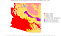
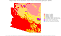
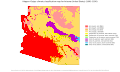 Koppen-Geiger Map v2 USA Arizona 1901–1930.svg 1,431 × 850; 618 KB
-
 Koppen-Geiger Map v2 USA Arizona 1931–1960.svg 1,420 × 850; 611 KB
-
 Koppen-Geiger Map v2 USA Arizona 1961–1990.svg 1,420 × 850; 612 KB
-
 Koppen-Geiger Map v2 USA Arizona 1991–2020.svg 1,431 × 850; 613 KB
-
 Koppen-Geiger Map v2 USA Arizona 2041–2070 SSP126.svg 1,431 × 850; 613 KB
-
 Koppen-Geiger Map v2 USA Arizona 2041–2070 SSP245.svg 1,431 × 850; 610 KB
-
 Koppen-Geiger Map v2 USA Arizona 2041–2070 SSP370.svg 1,431 × 850; 608 KB
-
 Koppen-Geiger Map v2 USA Arizona 2041–2070 SSP434.svg 1,420 × 850; 606 KB
-
 Koppen-Geiger Map v2 USA Arizona 2041–2070 SSP460.svg 1,420 × 850; 606 KB
-
 Koppen-Geiger Map v2 USA Arizona 2041–2070 SSP585.svg 1,431 × 850; 608 KB
-
 Koppen-Geiger Map v2 USA Arizona 2071–2099 SSP126.svg 1,431 × 850; 613 KB
-
 Koppen-Geiger Map v2 USA Arizona 2071–2099 SSP245.svg 1,431 × 850; 607 KB
-
 Koppen-Geiger Map v2 USA Arizona 2071–2099 SSP370.svg 1,420 × 850; 602 KB
-
 Koppen-Geiger Map v2 USA Arizona 2071–2099 SSP434.svg 1,420 × 850; 606 KB
-
 Koppen-Geiger Map v2 USA Arizona 2071–2099 SSP460.svg 1,420 × 850; 602 KB
-
 Koppen-Geiger Map v2 USA Arizona 2071–2099 SSP585.svg 1,420 × 850; 608 KB
-
 Koppen-Geiger Map v2 USA Arkansas 1901–1930.svg 1,555 × 850; 672 KB
-
 Koppen-Geiger Map v2 USA Arkansas 1931–1960.svg 1,555 × 850; 672 KB
-
 Koppen-Geiger Map v2 USA Arkansas 1961–1990.svg 1,555 × 850; 672 KB
-
 Koppen-Geiger Map v2 USA Arkansas 1991–2020.svg 1,555 × 850; 672 KB
-
 Koppen-Geiger Map v2 USA Arkansas 2041–2070 SSP126.svg 1,555 × 850; 672 KB
-
 Koppen-Geiger Map v2 USA Arkansas 2041–2070 SSP245.svg 1,555 × 850; 672 KB
-
 Koppen-Geiger Map v2 USA Arkansas 2041–2070 SSP370.svg 1,555 × 850; 672 KB
-
 Koppen-Geiger Map v2 USA Arkansas 2041–2070 SSP434.svg 1,555 × 850; 672 KB
-
 Koppen-Geiger Map v2 USA Arkansas 2041–2070 SSP460.svg 1,555 × 850; 672 KB
-
 Koppen-Geiger Map v2 USA Arkansas 2041–2070 SSP585.svg 1,555 × 850; 672 KB
-
 Koppen-Geiger Map v2 USA Arkansas 2071–2099 SSP126.svg 1,555 × 850; 672 KB
-
 Koppen-Geiger Map v2 USA Arkansas 2071–2099 SSP245.svg 1,555 × 850; 672 KB
-
 Koppen-Geiger Map v2 USA Arkansas 2071–2099 SSP370.svg 1,555 × 850; 672 KB
-
 Koppen-Geiger Map v2 USA Arkansas 2071–2099 SSP434.svg 1,555 × 850; 672 KB
-
 Koppen-Geiger Map v2 USA Arkansas 2071–2099 SSP460.svg 1,555 × 850; 672 KB
-
 Koppen-Geiger Map v2 USA Arkansas 2071–2099 SSP585.svg 1,555 × 850; 672 KB
-
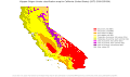
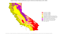 Koppen-Geiger Map v2 USA California 1901–1930.svg 1,444 × 850; 903 KB
-
 Koppen-Geiger Map v2 USA California 1931–1960.svg 1,444 × 850; 903 KB
-
 Koppen-Geiger Map v2 USA California 1961–1990.svg 1,444 × 850; 904 KB
-
 Koppen-Geiger Map v2 USA California 1991–2020.svg 1,444 × 850; 910 KB
-
 Koppen-Geiger Map v2 USA California 2041–2070 SSP126.svg 1,444 × 850; 887 KB
-
 Koppen-Geiger Map v2 USA California 2041–2070 SSP245.svg 1,444 × 850; 886 KB
-
 Koppen-Geiger Map v2 USA California 2041–2070 SSP370.svg 1,444 × 850; 886 KB
-
 Koppen-Geiger Map v2 USA California 2041–2070 SSP434.svg 1,444 × 850; 890 KB
-
 Koppen-Geiger Map v2 USA California 2041–2070 SSP460.svg 1,444 × 850; 889 KB
-
 Koppen-Geiger Map v2 USA California 2041–2070 SSP585.svg 1,444 × 850; 884 KB
-
 Koppen-Geiger Map v2 USA California 2071–2099 SSP126.svg 1,444 × 850; 886 KB
-
 Koppen-Geiger Map v2 USA California 2071–2099 SSP245.svg 1,444 × 850; 882 KB
-
 Koppen-Geiger Map v2 USA California 2071–2099 SSP370.svg 1,444 × 850; 869 KB
-
 Koppen-Geiger Map v2 USA California 2071–2099 SSP434.svg 1,444 × 850; 889 KB
-
 Koppen-Geiger Map v2 USA California 2071–2099 SSP460.svg 1,444 × 850; 883 KB
-
 Koppen-Geiger Map v2 USA California 2071–2099 SSP585.svg 1,444 × 850; 854 KB
-
 Koppen-Geiger Map v2 USA Colorado 1901–1930.svg 1,729 × 850; 869 KB
-
 Koppen-Geiger Map v2 USA Colorado 1931–1960.svg 1,729 × 850; 851 KB
-
 Koppen-Geiger Map v2 USA Colorado 1961–1990.svg 1,729 × 850; 855 KB
-
 Koppen-Geiger Map v2 USA Colorado 1991–2020.svg 1,729 × 850; 851 KB
-
 Koppen-Geiger Map v2 USA Colorado 2041–2070 SSP126.svg 1,729 × 850; 841 KB
-
 Koppen-Geiger Map v2 USA Colorado 2041–2070 SSP245.svg 1,729 × 850; 843 KB
-
 Koppen-Geiger Map v2 USA Colorado 2041–2070 SSP370.svg 1,729 × 850; 844 KB
-
 Koppen-Geiger Map v2 USA Colorado 2041–2070 SSP434.svg 1,729 × 850; 848 KB
-
 Koppen-Geiger Map v2 USA Colorado 2041–2070 SSP460.svg 1,729 × 850; 846 KB
-
 Koppen-Geiger Map v2 USA Colorado 2041–2070 SSP585.svg 1,729 × 850; 843 KB
-
 Koppen-Geiger Map v2 USA Colorado 2071–2099 SSP126.svg 1,729 × 850; 842 KB
-
 Koppen-Geiger Map v2 USA Colorado 2071–2099 SSP245.svg 1,729 × 850; 841 KB
-
 Koppen-Geiger Map v2 USA Colorado 2071–2099 SSP370.svg 1,729 × 850; 839 KB
-
 Koppen-Geiger Map v2 USA Colorado 2071–2099 SSP434.svg 1,729 × 850; 848 KB
-
 Koppen-Geiger Map v2 USA Colorado 2071–2099 SSP460.svg 1,729 × 850; 848 KB
-
 Koppen-Geiger Map v2 USA Colorado 2071–2099 SSP585.svg 1,776 × 850; 845 KB
-
 Koppen-Geiger Map v2 USA Connecticut 1901–1930.svg 1,769 × 850; 963 KB
-
 Koppen-Geiger Map v2 USA Connecticut 1931–1960.svg 1,798 × 850; 966 KB
-
 Koppen-Geiger Map v2 USA Connecticut 1961–1990.svg 1,769 × 850; 965 KB
-
 Koppen-Geiger Map v2 USA Connecticut 1991–2020.svg 1,798 × 850; 964 KB
-
 Koppen-Geiger Map v2 USA Connecticut 2041–2070 SSP126.svg 1,798 × 850; 964 KB
-
 Koppen-Geiger Map v2 USA Connecticut 2041–2070 SSP245.svg 1,798 × 850; 962 KB
-
 Koppen-Geiger Map v2 USA Connecticut 2041–2070 SSP370.svg 1,798 × 850; 961 KB
-
 Koppen-Geiger Map v2 USA Connecticut 2041–2070 SSP434.svg 1,798 × 850; 964 KB
-
 Koppen-Geiger Map v2 USA Connecticut 2041–2070 SSP460.svg 1,798 × 850; 961 KB
-
 Koppen-Geiger Map v2 USA Connecticut 2041–2070 SSP585.svg 1,798 × 850; 960 KB
-
 Koppen-Geiger Map v2 USA Connecticut 2071–2099 SSP126.svg 1,798 × 850; 964 KB
-
 Koppen-Geiger Map v2 USA Connecticut 2071–2099 SSP245.svg 1,798 × 850; 960 KB
-
 Koppen-Geiger Map v2 USA Connecticut 2071–2099 SSP370.svg 1,798 × 850; 959 KB
-
 Koppen-Geiger Map v2 USA Connecticut 2071–2099 SSP434.svg 1,798 × 850; 961 KB
-
 Koppen-Geiger Map v2 USA Connecticut 2071–2099 SSP460.svg 1,798 × 850; 960 KB
-
 Koppen-Geiger Map v2 USA Connecticut 2071–2099 SSP585.svg 1,798 × 850; 955 KB
-
 Koppen-Geiger Map v2 USA Delaware 1901–1930.svg 1,229 × 850; 408 KB
-
 Koppen-Geiger Map v2 USA Delaware 1931–1960.svg 1,229 × 850; 405 KB
-
 Koppen-Geiger Map v2 USA Delaware 1961–1990.svg 1,229 × 850; 408 KB
-
 Koppen-Geiger Map v2 USA Delaware 1991–2020.svg 1,229 × 850; 405 KB
-
 Koppen-Geiger Map v2 USA Delaware 2041–2070 SSP126.svg 1,229 × 850; 405 KB
-
 Koppen-Geiger Map v2 USA Delaware 2041–2070 SSP245.svg 1,229 × 850; 405 KB
-
 Koppen-Geiger Map v2 USA Delaware 2041–2070 SSP370.svg 1,229 × 850; 405 KB
-
 Koppen-Geiger Map v2 USA Delaware 2041–2070 SSP434.svg 1,229 × 850; 405 KB
-
 Koppen-Geiger Map v2 USA Delaware 2041–2070 SSP460.svg 1,229 × 850; 405 KB
-
 Koppen-Geiger Map v2 USA Delaware 2041–2070 SSP585.svg 1,229 × 850; 405 KB
-
 Koppen-Geiger Map v2 USA Delaware 2071–2099 SSP126.svg 1,229 × 850; 405 KB
-
 Koppen-Geiger Map v2 USA Delaware 2071–2099 SSP245.svg 1,229 × 850; 405 KB
-
 Koppen-Geiger Map v2 USA Delaware 2071–2099 SSP370.svg 1,229 × 850; 405 KB
-
 Koppen-Geiger Map v2 USA Delaware 2071–2099 SSP434.svg 1,229 × 850; 405 KB
-
 Koppen-Geiger Map v2 USA Delaware 2071–2099 SSP460.svg 1,229 × 850; 405 KB
-
 Koppen-Geiger Map v2 USA Delaware 2071–2099 SSP585.svg 1,229 × 850; 405 KB
-
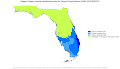
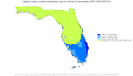
 Koppen-Geiger Map v2 USA Florida 1901–1930.svg 1,485 × 850; 2.46 MB
-
 Koppen-Geiger Map v2 USA Florida 1931–1960.svg 1,485 × 850; 2.46 MB
-
 Koppen-Geiger Map v2 USA Florida 1961–1990.svg 1,485 × 850; 2.46 MB
-
 Koppen-Geiger Map v2 USA Florida 1991–2020.svg 1,485 × 850; 2.46 MB
-
 Koppen-Geiger Map v2 USA Florida 2041–2070 SSP126.svg 1,485 × 850; 2.46 MB
-
 Koppen-Geiger Map v2 USA Florida 2041–2070 SSP245.svg 1,485 × 850; 2.46 MB
-
 Koppen-Geiger Map v2 USA Florida 2041–2070 SSP370.svg 1,485 × 850; 2.46 MB
-
 Koppen-Geiger Map v2 USA Florida 2041–2070 SSP434.svg 1,485 × 850; 2.46 MB
-
 Koppen-Geiger Map v2 USA Florida 2041–2070 SSP460.svg 1,485 × 850; 2.46 MB
-
 Koppen-Geiger Map v2 USA Florida 2041–2070 SSP585.svg 1,485 × 850; 2.46 MB
-
 Koppen-Geiger Map v2 USA Florida 2071–2099 SSP126.svg 1,485 × 850; 2.46 MB
-
 Koppen-Geiger Map v2 USA Florida 2071–2099 SSP245.svg 1,485 × 850; 2.46 MB
-
 Koppen-Geiger Map v2 USA Florida 2071–2099 SSP370.svg 1,485 × 850; 2.47 MB
-
 Koppen-Geiger Map v2 USA Florida 2071–2099 SSP434.svg 1,485 × 850; 2.46 MB
-
 Koppen-Geiger Map v2 USA Florida 2071–2099 SSP460.svg 1,485 × 850; 2.47 MB
-
 Koppen-Geiger Map v2 USA Florida 2071–2099 SSP585.svg 1,485 × 850; 2.47 MB
-
 Koppen-Geiger Map v2 USA Georgia 1901–1930.svg 1,435 × 850; 699 KB
-
 Koppen-Geiger Map v2 USA Georgia 1931–1960.svg 1,435 × 850; 699 KB
-
 Koppen-Geiger Map v2 USA Georgia 1961–1990.svg 1,435 × 850; 701 KB
-
 Koppen-Geiger Map v2 USA Georgia 1991–2020.svg 1,435 × 850; 698 KB
-
 Koppen-Geiger Map v2 USA Georgia 2041–2070 SSP126.svg 1,435 × 850; 697 KB
-
 Koppen-Geiger Map v2 USA Georgia 2041–2070 SSP245.svg 1,435 × 850; 697 KB
-
 Koppen-Geiger Map v2 USA Georgia 2041–2070 SSP370.svg 1,435 × 850; 697 KB
-
 Koppen-Geiger Map v2 USA Georgia 2041–2070 SSP434.svg 1,435 × 850; 697 KB
-
 Koppen-Geiger Map v2 USA Georgia 2041–2070 SSP460.svg 1,435 × 850; 697 KB
-
 Koppen-Geiger Map v2 USA Georgia 2041–2070 SSP585.svg 1,435 × 850; 697 KB
-
 Koppen-Geiger Map v2 USA Georgia 2071–2099 SSP126.svg 1,435 × 850; 697 KB
-
 Koppen-Geiger Map v2 USA Georgia 2071–2099 SSP245.svg 1,435 × 850; 697 KB
-
 Koppen-Geiger Map v2 USA Georgia 2071–2099 SSP370.svg 1,416 × 850; 694 KB
-
 Koppen-Geiger Map v2 USA Georgia 2071–2099 SSP434.svg 1,435 × 850; 697 KB
-
 Koppen-Geiger Map v2 USA Georgia 2071–2099 SSP460.svg 1,416 × 850; 694 KB
-
 Koppen-Geiger Map v2 USA Georgia 2071–2099 SSP585.svg 1,416 × 850; 694 KB
-
 Koppen-Geiger Map v2 USA Hawaii 1901–1930.svg 1,816 × 850; 821 KB
-
 Koppen-Geiger Map v2 USA Hawaii 1931–1960.svg 1,816 × 850; 819 KB
-
 Koppen-Geiger Map v2 USA Hawaii 1961–1990.svg 1,816 × 850; 821 KB
-
 Koppen-Geiger Map v2 USA Hawaii 1991–2020.svg 1,816 × 850; 825 KB
-
 Koppen-Geiger Map v2 USA Hawaii 2041–2070 SSP126.svg 1,816 × 850; 823 KB
-
 Koppen-Geiger Map v2 USA Hawaii 2041–2070 SSP245.svg 1,816 × 850; 823 KB
-
 Koppen-Geiger Map v2 USA Hawaii 2041–2070 SSP370.svg 1,816 × 850; 823 KB
-
 Koppen-Geiger Map v2 USA Hawaii 2041–2070 SSP434.svg 1,816 × 850; 822 KB
-
 Koppen-Geiger Map v2 USA Hawaii 2041–2070 SSP460.svg 1,816 × 850; 823 KB
-
 Koppen-Geiger Map v2 USA Hawaii 2041–2070 SSP585.svg 1,816 × 850; 823 KB
-
 Koppen-Geiger Map v2 USA Hawaii 2071–2099 SSP126.svg 1,816 × 850; 823 KB
-
 Koppen-Geiger Map v2 USA Hawaii 2071–2099 SSP245.svg 1,816 × 850; 823 KB
-
 Koppen-Geiger Map v2 USA Hawaii 2071–2099 SSP370.svg 1,816 × 850; 823 KB
-
 Koppen-Geiger Map v2 USA Hawaii 2071–2099 SSP434.svg 1,816 × 850; 823 KB
-
 Koppen-Geiger Map v2 USA Hawaii 2071–2099 SSP460.svg 1,816 × 850; 824 KB
-
 Koppen-Geiger Map v2 USA Hawaii 2071–2099 SSP585.svg 1,816 × 850; 823 KB
-
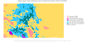
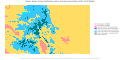
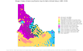
 Koppen-Geiger Map v2 USA Idaho 1901–1930.svg 1,355 × 850; 627 KB
-
 Koppen-Geiger Map v2 USA Idaho 1931–1960.svg 1,355 × 850; 629 KB
-
 Koppen-Geiger Map v2 USA Idaho 1961–1990.svg 1,373 × 850; 629 KB
-
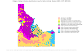
 Koppen-Geiger Map v2 USA Idaho 1991–2020.svg 1,384 × 850; 644 KB
-
 Koppen-Geiger Map v2 USA Idaho 2041–2070 SSP126.svg 1,384 × 850; 641 KB
-
 Koppen-Geiger Map v2 USA Idaho 2041–2070 SSP245.svg 1,384 × 850; 648 KB
-
 Koppen-Geiger Map v2 USA Idaho 2041–2070 SSP370.svg 1,384 × 850; 650 KB
-
 Koppen-Geiger Map v2 USA Idaho 2041–2070 SSP434.svg 1,384 × 850; 650 KB


