Category:Köppen-Geiger Climate Classification Maps for 1961–1990
Jump to navigation
Jump to search
Media in category "Köppen-Geiger Climate Classification Maps for 1961–1990"
The following 200 files are in this category, out of 485 total.
(previous page) (next page)-
 Koppen-Geiger Map v2 A 1961–1990.svg 1,401 × 928; 26.65 MB
-
 Koppen-Geiger Map v2 Af 1961–1990.svg 1,401 × 928; 26.61 MB
-
 Koppen-Geiger Map v2 AFG 1961–1990.svg 1,644 × 850; 1.07 MB
-
 Koppen-Geiger Map v2 Africa 1961–1990.svg 1,506 × 850; 2.57 MB
-
 Koppen-Geiger Map v2 AGO 1961–1990.svg 1,381 × 850; 766 KB
-
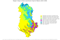 Koppen-Geiger Map v2 ALB 1961–1990.svg 1,275 × 850; 520 KB
-
 Koppen-Geiger Map v2 Am 1961–1990.svg 1,401 × 928; 26.62 MB
-
 Koppen-Geiger Map v2 ARE 1961–1990.svg 1,390 × 850; 1.07 MB
-
 Koppen-Geiger Map v2 ARG 1961–1990.svg 1,278 × 850; 1.62 MB
-
 Koppen-Geiger Map v2 ARG Buenos Aires 1961–1990.svg 1,378 × 850; 1.07 MB
-
 Koppen-Geiger Map v2 ARG Catamarca 1961–1990.svg 1,353 × 850; 524 KB
-
 Koppen-Geiger Map v2 ARG Chaco 1961–1990.svg 1,511 × 850; 638 KB
-
 Koppen-Geiger Map v2 ARG Chubut 1961–1990.svg 1,816 × 850; 1.03 MB
-
 Koppen-Geiger Map v2 ARG Corrientes 1961–1990.svg 1,464 × 850; 586 KB
-
 Koppen-Geiger Map v2 ARG Córdoba 1961–1990.svg 1,326 × 850; 446 KB
-
 Koppen-Geiger Map v2 ARG Entre Ríos 1961–1990.svg 1,321 × 850; 441 KB
-
 Koppen-Geiger Map v2 ARG Formosa 1961–1990.svg 1,438 × 850; 577 KB
-
 Koppen-Geiger Map v2 ARG Jujuy 1961–1990.svg 1,431 × 850; 591 KB
-
 Koppen-Geiger Map v2 ARG La Pampa 1961–1990.svg 1,455 × 850; 574 KB
-
 Koppen-Geiger Map v2 ARG La Rioja 1961–1990.svg 1,399 × 850; 548 KB
-
 Koppen-Geiger Map v2 ARG Mendoza 1961–1990.svg 1,326 × 850; 505 KB
-
 Koppen-Geiger Map v2 ARG Misiones 1961–1990.svg 1,400 × 850; 508 KB
-
 Koppen-Geiger Map v2 ARG Neuquén 1961–1990.svg 1,349 × 850; 546 KB
-
 Koppen-Geiger Map v2 ARG Río Negro 1961–1990.svg 1,816 × 850; 847 KB
-
 Koppen-Geiger Map v2 ARG Salta 1961–1990.svg 1,551 × 850; 757 KB
-
 Koppen-Geiger Map v2 ARG San Juan 1961–1990.svg 1,368 × 850; 533 KB
-
 Koppen-Geiger Map v2 ARG San Luis 1961–1990.svg 1,280 × 850; 395 KB
-
 Koppen-Geiger Map v2 ARG Santa Cruz 1961–1990.svg 1,505 × 850; 883 KB
-
 Koppen-Geiger Map v2 ARG Santa Fe 1961–1990.svg 1,270 × 850; 377 KB
-
 Koppen-Geiger Map v2 ARG Santiago del Estero 1961–1990.svg 1,306 × 850; 417 KB
-
 Koppen-Geiger Map v2 ARG Tierra del Fuego 1961–1990.svg 1,804 × 850; 1.18 MB
-
 Koppen-Geiger Map v2 ARG Tucumán 1961–1990.svg 1,358 × 850; 481 KB
-
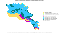 Koppen-Geiger Map v2 ARM 1961–1990.svg 1,526 × 850; 668 KB
-
 Koppen-Geiger Map v2 Asia 1961–1990.svg 1,803 × 850; 6.05 MB
-
 Koppen-Geiger Map v2 Asiatic Russia 1961–1990.svg 1,780 × 850; 2.8 MB
-
 Koppen-Geiger Map v2 AUS 1961–1990.svg 1,428 × 850; 5.12 MB
-
 Koppen-Geiger Map v2 AUS New South Wales 1961–1990.svg 1,816 × 850; 1.29 MB
-
 Koppen-Geiger Map v2 AUS Northern Territory 1961–1990.svg 1,184 × 850; 768 KB
-
 Koppen-Geiger Map v2 AUS Queensland 1961–1990.svg 1,345 × 850; 1.58 MB
-
 Koppen-Geiger Map v2 AUS South Australia 1961–1990.svg 1,411 × 850; 863 KB
-
 Koppen-Geiger Map v2 AUS Victoria 1961–1990.svg 1,771 × 850; 1.18 MB
-
 Koppen-Geiger Map v2 AUS Western Australia 1961–1990.svg 1,323 × 850; 2.11 MB
-
 Koppen-Geiger Map v2 Australia–New Zealand 1961–1990.svg 1,664 × 850; 3.05 MB
-
 Koppen-Geiger Map v2 AUT 1961–1990.svg 1,816 × 850; 670 KB
-
 Koppen-Geiger Map v2 Aw 1961–1990.svg 1,401 × 928; 26.63 MB
-
 Koppen-Geiger Map v2 B 1961–1990.svg 1,401 × 928; 26.68 MB
-
 Koppen-Geiger Map v2 BDI 1961–1990.svg 1,363 × 850; 566 KB
-
 Koppen-Geiger Map v2 BEL 1961–1990.svg 1,816 × 850; 817 KB
-
 Koppen-Geiger Map v2 BEN 1961–1990.svg 1,184 × 850; 353 KB
-
 Koppen-Geiger Map v2 BFA 1961–1990.svg 1,388 × 850; 709 KB
-
 Koppen-Geiger Map v2 BGD 1961–1990.svg 1,310 × 850; 1.15 MB
-
 Koppen-Geiger Map v2 BGR 1961–1990.svg 1,816 × 850; 913 KB
-
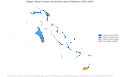 Koppen-Geiger Map v2 BHS 1961–1990.svg 1,326 × 850; 2.53 MB
-
 Koppen-Geiger Map v2 BIH 1961–1990.svg 1,578 × 850; 716 KB
-
 Koppen-Geiger Map v2 BLR 1961–1990.svg 1,769 × 850; 829 KB
-
 Koppen-Geiger Map v2 BLZ 1961–1990.svg 1,304 × 850; 963 KB
-
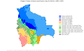 Koppen-Geiger Map v2 BOL 1961–1990.svg 1,398 × 850; 820 KB
-
 Koppen-Geiger Map v2 BRA 1961–1990.svg 1,480 × 850; 2.45 MB
-
 Koppen-Geiger Map v2 BRA Acre 1961–1990.svg 1,640 × 850; 849 KB
-
 Koppen-Geiger Map v2 BRA Alagoas 1961–1990.svg 1,640 × 850; 879 KB
-
 Koppen-Geiger Map v2 BRA Amapá 1961–1990.svg 1,206 × 850; 583 KB
-
 Koppen-Geiger Map v2 BRA Bahia 1961–1990.svg 1,406 × 850; 902 KB
-
 Koppen-Geiger Map v2 BRA Ceará 1961–1990.svg 1,185 × 850; 546 KB
-
 Koppen-Geiger Map v2 BRA Goiás 1961–1990.svg 1,415 × 850; 604 KB
-
 Koppen-Geiger Map v2 BRA Maranhão 1961–1990.svg 1,184 × 850; 838 KB
-
 Koppen-Geiger Map v2 BRA Mato Grosso 1961–1990.svg 1,426 × 850; 647 KB
-
 Koppen-Geiger Map v2 BRA Mato Grosso do Sul 1961–1990.svg 1,425 × 850; 610 KB
-
 Koppen-Geiger Map v2 BRA Minas Gerais 1961–1990.svg 1,526 × 850; 887 KB
-
 Koppen-Geiger Map v2 BRA Paraná 1961–1990.svg 1,651 × 850; 952 KB
-
 Koppen-Geiger Map v2 BRA Pará 1961–1990.svg 1,260 × 850; 823 KB
-
 Koppen-Geiger Map v2 BRA Pernambuco 1961–1990.svg 1,804 × 850; 658 KB
-
 Koppen-Geiger Map v2 BRA Piauí 1961–1990.svg 1,184 × 850; 444 KB
-
 Koppen-Geiger Map v2 BRA Rio de Janeiro 1961–1990.svg 1,609 × 850; 1.22 MB
-
 Koppen-Geiger Map v2 BRA Rio Grande do Sul 1961–1990.svg 1,491 × 850; 842 KB
-
 Koppen-Geiger Map v2 BRA Rondônia 1961–1990.svg 1,340 × 850; 661 KB
-
 Koppen-Geiger Map v2 BRA Roraima 1961–1990.svg 1,378 × 850; 524 KB
-
 Koppen-Geiger Map v2 BRA Sergipe 1961–1990.svg 1,194 × 850; 538 KB
-
 Koppen-Geiger Map v2 BRA São Paulo 1961–1990.svg 1,725 × 850; 1.09 MB
-
 Koppen-Geiger Map v2 BRA Tocantins 1961–1990.svg 1,184 × 850; 414 KB
-
 Koppen-Geiger Map v2 BSh 1961–1990.svg 1,401 × 928; 26.62 MB
-
 Koppen-Geiger Map v2 BSk 1961–1990.svg 1,401 × 928; 26.64 MB
-
 Koppen-Geiger Map v2 BTN 1961–1990.svg 1,794 × 850; 771 KB
-
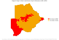 Koppen-Geiger Map v2 BWA 1961–1990.svg 1,254 × 850; 606 KB
-
 Koppen-Geiger Map v2 BWh 1961–1990.svg 1,401 × 928; 26.62 MB
-
 Koppen-Geiger Map v2 BWk 1961–1990.svg 1,401 × 928; 26.62 MB
-
 Koppen-Geiger Map v2 C 1961–1990.svg 1,401 × 928; 26.69 MB
-
 Koppen-Geiger Map v2 CAF 1961–1990.svg 1,419 × 850; 791 KB
-
 Koppen-Geiger Map v2 CAN 1961–1990.svg 1,816 × 850; 23.26 MB
-
 Koppen-Geiger Map v2 CAN Alberta 1961–1990.svg 1,345 × 850; 605 KB
-
 Koppen-Geiger Map v2 CAN British Columbia 1961–1990.svg 1,816 × 850; 4.11 MB
-
 Koppen-Geiger Map v2 CAN Manitoba 1961–1990.svg 1,443 × 850; 738 KB
-
 Koppen-Geiger Map v2 CAN New Brunswick 1961–1990.svg 1,543 × 850; 1.08 MB
-
 Koppen-Geiger Map v2 CAN Newfoundland and Labrador 1961–1990.svg 1,363 × 850; 4 MB
-
 Koppen-Geiger Map v2 CAN Northwest Territories 1961–1990.svg 1,756 × 850; 2.68 MB
-
 Koppen-Geiger Map v2 CAN Nova Scotia 1961–1990.svg 1,736 × 850; 2.18 MB
-
 Koppen-Geiger Map v2 CAN Nunavut 1961–1990.svg 1,780 × 850; 11.04 MB
-
 Koppen-Geiger Map v2 CAN Ontario 1961–1990.svg 1,508 × 850; 983 KB
-
 Koppen-Geiger Map v2 CAN Prince Edward Island 1961–1990.svg 1,769 × 850; 1.05 MB
-
 Koppen-Geiger Map v2 CAN Québec 1961–1990.svg 1,475 × 850; 5.13 MB
-
 Koppen-Geiger Map v2 CAN Saskatchewan 1961–1990.svg 1,300 × 850; 476 KB
-
 Koppen-Geiger Map v2 CAN Yukon 1961–1990.svg 1,593 × 850; 1.03 MB
-
 Koppen-Geiger Map v2 Caribbean 1961–1990.svg 1,610 × 850; 1.58 MB
-
 Koppen-Geiger Map v2 Central America 1961–1990.svg 1,683 × 850; 2.77 MB
-
 Koppen-Geiger Map v2 Central Asia 1961–1990.svg 1,786 × 850; 1.8 MB
-
 Koppen-Geiger Map v2 Cfa 1961–1990.svg 1,401 × 928; 26.61 MB
-
 Koppen-Geiger Map v2 Cfb 1961–1990.svg 1,401 × 928; 26.62 MB
-
 Koppen-Geiger Map v2 Cfc 1961–1990.svg 1,401 × 928; 26.6 MB
-
 Koppen-Geiger Map v2 CHE 1961–1990.svg 1,816 × 850; 790 KB
-
 Koppen-Geiger Map v2 CHL 1961–1990.svg 1,468 × 850; 8.28 MB
-
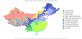 Koppen-Geiger Map v2 CHN 1961–1990.svg 1,763 × 850; 5.17 MB
-
 Koppen-Geiger Map v2 CHN Anhui 1961–1990.svg 1,393 × 850; 570 KB
-
 Koppen-Geiger Map v2 CHN Beijing 1961–1990.svg 1,458 × 850; 636 KB
-
 Koppen-Geiger Map v2 CHN Chongqing 1961–1990.svg 1,500 × 850; 696 KB
-
 Koppen-Geiger Map v2 CHN Fujian 1961–1990.svg 1,441 × 850; 1.47 MB
-
 Koppen-Geiger Map v2 CHN Gansu 1961–1990.svg 1,628 × 850; 952 KB
-
 Koppen-Geiger Map v2 CHN Guangdong 1961–1990.svg 1,580 × 850; 1.47 MB
-
 Koppen-Geiger Map v2 CHN Guangxi 1961–1990.svg 1,559 × 850; 962 KB
-
 Koppen-Geiger Map v2 CHN Guizhou 1961–1990.svg 1,531 × 850; 752 KB
-
 Koppen-Geiger Map v2 CHN Hainan 1961–1990.svg 1,519 × 850; 1,020 KB
-
 Koppen-Geiger Map v2 CHN Hebei 1961–1990.svg 1,346 × 850; 680 KB
-
 Koppen-Geiger Map v2 CHN Heilongjiang 1961–1990.svg 1,474 × 850; 812 KB
-
 Koppen-Geiger Map v2 CHN Henan 1961–1990.svg 1,499 × 850; 714 KB
-
 Koppen-Geiger Map v2 CHN Hubei 1961–1990.svg 1,816 × 850; 962 KB
-
 Koppen-Geiger Map v2 CHN Hunan 1961–1990.svg 1,424 × 850; 606 KB
-
 Koppen-Geiger Map v2 CHN Jiangsu 1961–1990.svg 1,505 × 850; 800 KB
-
 Koppen-Geiger Map v2 CHN Jiangxi 1961–1990.svg 1,381 × 850; 529 KB
-
 Koppen-Geiger Map v2 CHN Jilin 1961–1990.svg 1,730 × 850; 911 KB
-
 Koppen-Geiger Map v2 CHN Liaoning 1961–1990.svg 1,525 × 850; 1.18 MB
-
 Koppen-Geiger Map v2 CHN Nei Mongol 1961–1990.svg 1,746 × 850; 1.1 MB
-
 Koppen-Geiger Map v2 CHN Ningxia Hui 1961–1990.svg 1,289 × 850; 494 KB
-
 Koppen-Geiger Map v2 CHN Qinghai 1961–1990.svg 1,709 × 850; 995 KB
-
 Koppen-Geiger Map v2 CHN Shaanxi 1961–1990.svg 1,306 × 850; 593 KB
-
 Koppen-Geiger Map v2 CHN Shandong 1961–1990.svg 1,776 × 850; 1.17 MB
-
 Koppen-Geiger Map v2 CHN Shanghai 1961–1990.svg 1,588 × 850; 1.32 MB
-
 Koppen-Geiger Map v2 CHN Shanxi 1961–1990.svg 1,276 × 850; 506 KB
-
 Koppen-Geiger Map v2 CHN Sichuan 1961–1990.svg 1,549 × 850; 1 MB
-
 Koppen-Geiger Map v2 CHN Tianjin 1961–1990.svg 1,289 × 850; 472 KB
-
 Koppen-Geiger Map v2 CHN Xinjiang Uygur 1961–1990.svg 1,580 × 850; 1.07 MB
-
 Koppen-Geiger Map v2 CHN Xizang 1961–1990.svg 1,794 × 850; 1.17 MB
-
 Koppen-Geiger Map v2 CHN Yunnan 1961–1990.svg 1,449 × 850; 827 KB
-
 Koppen-Geiger Map v2 CHN Zhejiang 1961–1990.svg 1,501 × 850; 2.03 MB
-
 Koppen-Geiger Map v2 CIV 1961–1990.svg 1,234 × 850; 596 KB
-
 Koppen-Geiger Map v2 CMR 1961–1990.svg 1,294 × 850; 538 KB
-
 Koppen-Geiger Map v2 COD 1961–1990.svg 1,430 × 850; 825 KB
-
 Koppen-Geiger Map v2 COG 1961–1990.svg 1,196 × 850; 554 KB
-
 Koppen-Geiger Map v2 COL 1961–1990.svg 1,333 × 850; 986 KB
-
 Koppen-Geiger Map v2 CRI 1961–1990.svg 1,351 × 850; 729 KB
-
 Koppen-Geiger Map v2 Csa 1961–1990.svg 1,401 × 928; 26.61 MB
-
 Koppen-Geiger Map v2 Csb 1961–1990.svg 1,401 × 928; 26.61 MB
-
 Koppen-Geiger Map v2 Csc 1961–1990.svg 1,401 × 928; 26.6 MB
-
 Koppen-Geiger Map v2 CUB 1961–1990.svg 1,816 × 850; 3 MB
-
 Koppen-Geiger Map v2 Cwa 1961–1990.svg 1,401 × 928; 26.62 MB
-
 Koppen-Geiger Map v2 Cwb 1961–1990.svg 1,401 × 928; 26.62 MB
-
 Koppen-Geiger Map v2 Cwc 1961–1990.svg 1,401 × 928; 26.6 MB
-
 Koppen-Geiger Map v2 CYP 1961–1990.svg 1,804 × 850; 692 KB
-
 Koppen-Geiger Map v2 CZE 1961–1990.svg 1,769 × 850; 691 KB
-
 Koppen-Geiger Map v2 D 1961–1990.svg 1,401 × 928; 26.72 MB
-
 Koppen-Geiger Map v2 DEU 1961–1990.svg 1,488 × 850; 1.11 MB
-
 Koppen-Geiger Map v2 Dfa 1961–1990.svg 1,401 × 928; 26.61 MB
-
 Koppen-Geiger Map v2 Dfb 1961–1990.svg 1,401 × 928; 26.62 MB
-
 Koppen-Geiger Map v2 Dfc 1961–1990.svg 1,401 × 928; 26.64 MB
-
 Koppen-Geiger Map v2 Dfd 1961–1990.svg 1,401 × 928; 26.6 MB
-
 Koppen-Geiger Map v2 DJI 1961–1990.svg 1,221 × 850; 585 KB
-
 Koppen-Geiger Map v2 DNK 1961–1990.svg 1,816 × 850; 1.99 MB
-
 Koppen-Geiger Map v2 DOM 1961–1990.svg 1,599 × 850; 1.11 MB
-
 Koppen-Geiger Map v2 Dsa 1961–1990.svg 1,401 × 928; 26.6 MB
-
 Koppen-Geiger Map v2 Dsb 1961–1990.svg 1,401 × 928; 26.61 MB
-
 Koppen-Geiger Map v2 Dsc 1961–1990.svg 1,401 × 928; 26.62 MB
-
 Koppen-Geiger Map v2 Dsd 1961–1990.svg 1,401 × 928; 26.6 MB
-
 Koppen-Geiger Map v2 Dwa 1961–1990.svg 1,401 × 928; 26.6 MB
-
 Koppen-Geiger Map v2 Dwb 1961–1990.svg 1,401 × 928; 26.61 MB
-
 Koppen-Geiger Map v2 Dwc 1961–1990.svg 1,401 × 928; 26.62 MB
-
 Koppen-Geiger Map v2 Dwd 1961–1990.svg 1,401 × 928; 26.6 MB
-
 Koppen-Geiger Map v2 DZA 1961–1990.svg 1,474 × 850; 734 KB
-
 Koppen-Geiger Map v2 E 1961–1990.svg 1,401 × 928; 26.65 MB
-
 Koppen-Geiger Map v2 Eastern Africa 1961–1990.svg 1,399 × 850; 2.53 MB
-
 Koppen-Geiger Map v2 Eastern Asia 1961–1990.svg 1,816 × 850; 4.84 MB
-
 Koppen-Geiger Map v2 Eastern Europe 1961–1990.svg 1,620 × 850; 2.68 MB
-
 Koppen-Geiger Map v2 ECU 1961–1990.svg 1,816 × 850; 973 KB
-
 Koppen-Geiger Map v2 EF 1961–1990.svg 1,401 × 928; 26.61 MB
-
 Koppen-Geiger Map v2 EGY 1961–1990.svg 1,303 × 850; 825 KB
-
 Koppen-Geiger Map v2 ERI 1961–1990.svg 1,490 × 850; 1.12 MB
-
 Koppen-Geiger Map v2 ESH 1961–1990.svg 1,318 × 850; 684 KB
-
 Koppen-Geiger Map v2 ESP 1961–1990.svg 1,563 × 850; 1.28 MB
-
 Koppen-Geiger Map v2 EST 1961–1990.svg 1,769 × 850; 2.8 MB
-
 Koppen-Geiger Map v2 ET 1961–1990.svg 1,401 × 928; 26.65 MB
-
 Koppen-Geiger Map v2 ETH 1961–1990.svg 1,533 × 850; 948 KB
-
 Koppen-Geiger Map v2 Europe 1961–1990.svg 1,816 × 850; 6.11 MB
-
 Koppen-Geiger Map v2 European Russia 1961–1990.svg 1,500 × 850; 1.97 MB
-
 Koppen-Geiger Map v2 FIN 1961–1990.svg 1,400 × 850; 3.17 MB
-
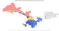
 Koppen-Geiger Map v2 FLK 1961–1990.svg 1,804 × 850; 3.23 MB
-
 Koppen-Geiger Map v2 FRA 1961–1990.svg 1,608 × 850; 1.67 MB
-
 Koppen-Geiger Map v2 GAB 1961–1990.svg 1,221 × 850; 742 KB
-
 Koppen-Geiger Map v2 GBR 1961–1990.svg 1,539 × 850; 2.48 MB
-
 Koppen-Geiger Map v2 GEO 1961–1990.svg 1,816 × 850; 742 KB
-
 Koppen-Geiger Map v2 GHA 1961–1990.svg 1,184 × 850; 515 KB
-
 Koppen-Geiger Map v2 GIN 1961–1990.svg 1,538 × 850; 945 KB
-
 Koppen-Geiger Map v2 GMB 1961–1990.svg 1,640 × 850; 461 KB
-
 Koppen-Geiger Map v2 GNB 1961–1990.svg 1,559 × 850; 1.64 MB
-
 Koppen-Geiger Map v2 GNQ 1961–1990.svg 1,456 × 850; 578 KB


