Category:June 2012 in Powys
Jump to navigation
Jump to search

Deutsch: Bilder, die im Juni 2012 in Powys aufgenommen worden sind. Bitte beachten Sie, dass dies weder das Datum des Uploads noch das Datum des Scannens eines Fotos ist.
English: Images/pictures taken in Powys during June 2012. Note this is not the date of the upload, nor the date a photo was scanned.
Español: Fotografías o imágenes tomadas en Powys durante junio 2012. No es la fecha de subida ni escaneo, sino la fecha en que las fotografías o imágenes se crearon.
Esperanto: Bildoj faritaj en Powys en junio 2012. Tio ne estas la dato, kiam la bildoj estis alŝutitaj aŭ skanitaj.
Français : Photographies ou images prises en Powys durant juin 2012. Ce n'est pas la date du téléchargement ou du scan.
Galego: Fotografías ou imaxes tomadas en Powys durante xuño 2012. Non é a data de subida nin escaneamento, senón a data na que se crearon as fotografías ou imaxes.
Italiano: Fotografie o immagini scattate a Powys nel giugno 2012. Nota bene: la data non si riferisce né a quella di upload né a quella in cui la foto è stata digitalizzata.
Norsk bokmål: Bilder tatt i Powys i løpet av juni 2012. Merk at dette ikke er datoen for opplasting, eller når et bilde har blitt skannet.
Norsk nynorsk: Bilete teke i Powys i løpet av juni 2012. Merk at dette ikkje er datoen for opplasting, eller når eit bilete har vorte skanna.
Русский: Изображения, сделанные в Powys в течение июнь 2012 (не дата загрузки изображения).
Українська: Зображення, зроблені в Powys протягом червень 2012. Зауважте, що це не дата завантаження чи дата сканування фотографії.
| June 2011 | ← | June 2012 | → | June 2013 | |||||||
| Jan | Feb | Mar | Apr | May | Jun | Jul | Aug | Sep | Oct | Nov | Dec |
| 0 | 0 | 20 | 9 | 31 | 18 | 13 | 21 | 46 | 9 | 6 | 0 |
|---|---|---|---|---|---|---|---|---|---|---|---|
Media in category "June 2012 in Powys"
The following 18 files are in this category, out of 18 total.
-
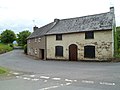
 Church House, Battle - geograph.org.uk - 2980530.jpg 640 × 448; 80 KB
-
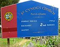 Church nameboard, St Cynog's, Battle - geograph.org.uk - 2980597.jpg 640 × 502; 83 KB
-
 Cradoc School - geograph.org.uk - 2980253.jpg 640 × 435; 57 KB
-

-
 Eastern boundary of Cradoc - geograph.org.uk - 2980937.jpg 640 × 475; 79 KB
-
 Entrance drive, Cradoc Golf Club - geograph.org.uk - 2980843.jpg 640 × 480; 104 KB
-
 Former Middle Lodge, Cradoc - geograph.org.uk - 2980922.jpg 640 × 538; 87 KB
-

-
 Lock-up garages, Cradoc - geograph.org.uk - 2980259.jpg 640 × 480; 84 KB
-

-
 Oakfield Park, Cradoc - geograph.org.uk - 2980161.jpg 640 × 480; 68 KB
-
 Pysgodlyn Farm, Cradoc - geograph.org.uk - 2980113.jpg 640 × 403; 67 KB
-
 Recycling area east of Cradoc - geograph.org.uk - 2981086.jpg 640 × 427; 56 KB
-

-
 Road to Cradoc Golf Course - geograph.org.uk - 2980183.jpg 640 × 480; 73 KB
-

-
 The Old Smithy, Cradoc - geograph.org.uk - 2980189.jpg 640 × 480; 65 KB
-


_-_geograph.org.uk_-_3019204.jpg)


