Category:Jüdischer Friedhof Hürben
Jump to navigation
Jump to search
| Object location | | View all coordinates using: OpenStreetMap |
|---|
This is the category of the Bavarian Baudenkmal (cultural heritage monument) with the ID D-7-74-150-4 (Wikidata)
|

Cultural heritage monument in Bavaria, Germany | |||||
| Upload media | |||||
| Instance of | |||||
|---|---|---|---|---|---|
| Location | Krumbach, Günzburg, Swabia, Bavaria, Germany | ||||
| Street address |
| ||||
| Has part(s) |
| ||||
| Heritage designation | |||||
 | |||||
Media in category "Jüdischer Friedhof Hürben"
The following 3 files are in this category, out of 3 total.
-
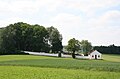 Jüdischer Friedhof Hürben 1.JPG 3,273 × 2,151; 6.16 MB
-
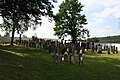
 Jüdischer Friedhof Hürben 2.JPG 3,456 × 2,304; 3.81 MB
-
 Jüdischer Friedhof Hürben 3.JPG 3,456 × 2,304; 4.17 MB


