Category:Interstate 10 in Louisiana
Jump to navigation
Jump to search
States of the United States: Alabama · Arizona · California · Florida · Louisiana · Mississippi · New Mexico · Texas
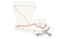
section of Interstate Highway in Louisiana, United States | |||||
| Upload media | |||||
| Instance of | |||||
|---|---|---|---|---|---|
| Part of | |||||
| Location | Louisiana | ||||
| Transport network |
| ||||
| Owned by | |||||
| Maintained by | |||||
| Inception |
| ||||
| Length |
| ||||
| Terminus | |||||
| |||||
Subcategories
This category has the following 16 subcategories, out of 16 total.
1
- Interstate 110 (Louisiana) (14 F)
2
3
4
5
6
9
A
- Atchafalaya Basin Bridge (19 F)
H
- Horace Wilkinson Bridge (24 F)
Media in category "Interstate 10 in Louisiana"
The following 121 files are in this category, out of 121 total.
-
A Bike Path in Metairie.jpg 3,648 × 2,736; 6.37 MB
-
Baton Rouge Adocate from I-10.jpg 3,800 × 1,621; 1.33 MB
-
Baton Rouge from I-10 5 Nov 2016 09.jpg 5,184 × 3,888; 4.32 MB
-
Baton Rouge from I-10 Nov 13 D.JPG 4,590 × 2,554; 3.09 MB
-
Baton Rouge from I-10 Nov 13 River Casino.JPG 4,604 × 2,307; 3.12 MB
-
Baton Rouge from I-10 Nov 13 River Skyline.JPG 4,602 × 2,466; 3.2 MB
-
Baton Rouge I-10 Ap2014 Lafayette.jpg 4,407 × 2,788; 2.88 MB
-
Baton Rouge I-10 Ap2014 MSBridgeAhead.jpg 4,604 × 2,951; 3.57 MB
-
Baton Rouge Upriver from I-10 Bridge.jpg 3,597 × 2,047; 1.44 MB
-
Baton Rouge, Louisiana 1955 Yellow Book.jpg 800 × 652; 127 KB
-
Canal Street, Metairie, Louisiana 25 Sept 2024 - 11.jpg 5,184 × 3,888; 10.53 MB
-
FEMA - 14537 - Photograph by Win Henderson taken on 08-31-2005 in Louisiana.jpg 3,008 × 2,000; 5.73 MB
-
FEMA - 17200 - Photograph by Robert Kaufmann taken on 10-15-2005 in Louisiana.jpg 3,300 × 2,066; 3.29 MB
-
FEMA - 18165 - Photograph by Jocelyn Augustino taken on 08-30-2005 in Louisiana.jpg 4,288 × 2,848; 2.95 MB
-
Flying out of Louisiana 2012.jpg 2,048 × 1,365; 285 KB
-
Fremaux Town Center mall, Slidell Louisiana, seen from I-10, 28 August 2021 - 01.jpg 5,184 × 3,509; 8.41 MB
-
Fremaux Town Center mall, Slidell Louisiana, seen from I-10, 28 August 2021 - 02.jpg 5,037 × 3,167; 7.31 MB
-
Hurricane Katrina rescue staging Aug31.jpg 3,008 × 2,000; 4.95 MB
-
I 10 Highrise over Pontchartrain East of New Orleans August 2009.jpg 2,816 × 2,112; 2.81 MB
-
I-10 (LA) map.svg 1,180 × 688; 2.04 MB
-
I-10 (LA).svg 601 × 601; 16 KB
-
I-10 and Causeway Boulevard Aerial (37733301804).jpg 1,600 × 2,400; 2.58 MB
-
I-10 and Jefferson Water Tower from Causeway Overpass, Metairie, Louisiana, March 2020.jpg 5,184 × 3,888; 8.71 MB
-
I-10 at LA1 Aerial Facing West (50887188606).jpg 3,600 × 2,400; 4.55 MB
-
I-10 East - Exit 206 - LA3188 LaPlace (28040194978).jpg 2,400 × 1,600; 1.33 MB
-
I-10 East - Exit 209 - US51 To I-55 North Sign (41867264652).jpg 2,400 × 1,600; 1.54 MB
-
I-10 East - Exit 223AB - LA49 MSY Airport (40103145620).jpg 2,400 × 1,600; 1.86 MB
-
I-10 East - MM196 - LA3188 Sign New Orleans 35 Miles (40103141660).jpg 2,400 × 1,600; 1.87 MB
-
I-10 East - MM210 - I-55 Overpass Frame (41867265882).jpg 2,400 × 1,600; 1.63 MB
-
I-10 East Exit 109 - LA 328 (33198087885).jpg 2,400 × 1,600; 1.63 MB
-
I-10 East Sunrise - MM163 - Baton Rouge (42134294682).jpg 2,400 × 1,600; 1.27 MB
-
I-10 Facing East at I-12 End Ramps (41459983584).jpg 2,400 × 1,600; 1.14 MB
-
I-10 Kenner Aerial (16462112349).jpg 800 × 1,200; 435 KB
-
I-10 Overlooking Lake Pontchartrain.jpg 2,630 × 1,680; 498 KB
-
I-10 Roadside Sunset (33070014301).jpg 2,400 × 1,600; 1.42 MB
-
I-10 Service Road, Metairie, Louisiana, 8 March 2023 - View to Interstate.jpg 5,184 × 3,888; 11.18 MB
-
I-10 West - Exit 159 - I-12 East (41280242545).jpg 2,400 × 1,600; 1.45 MB
-
I-10 West - Exit 163 - LA3246 Siegen Lane (42134289682).jpg 2,400 × 1,600; 1.42 MB
-
I-10 West - Exit 166 - LA42 LA427 (41459986084).jpg 2,400 × 1,600; 1.79 MB
-
I-10 West - Exit 267AB - I-12 West and I-59 North (41459849844).jpg 2,400 × 1,600; 1.79 MB
-
I-10 West - Exit 43 - LA383 (32462526665).jpg 2,400 × 1,600; 1.46 MB
-
I-10 West - MM155 - To Business US61 North Sign (40373608630).jpg 2,400 × 1,600; 1.44 MB
-
I-10 West - MM273 - Louisiana State Line (42134178582).jpg 2,400 × 1,600; 1.78 MB
-
I-10-Louisiana-Botts-Dots.JPG 3,888 × 2,592; 3.27 MB
-
I-12 East - Exit85ABC - I-10 and I-59 (40373521690).jpg 2,400 × 1,600; 1.52 MB
-
I-12 West End - Exit 1A - I-10 East (42134288362).jpg 2,400 × 1,600; 1.74 MB
-
I-610 and I-10 Split (33198033755).jpg 1,600 × 2,400; 2.06 MB
-
I10ClearviewWinHendersonCopter.jpg 3,008 × 2,000; 3.25 MB
-
I10MetairiePostKatrinaSalvationTrucks.jpg 3,008 × 2,000; 4.12 MB
-
Int10eRoad-Exit127-LA975 (33198090605).jpg 2,400 × 1,600; 1.45 MB
-
Int10eRoad-Exit135-LA3000 (33198093105).jpg 2,400 × 1,600; 1.38 MB
-
Int10eRoad-Exit155B-Int110 (33156386866).jpg 2,400 × 1,600; 1.68 MB
-
Int10eRoad-Exit223AB-LA49-MSY (24576958928).jpg 2,400 × 1,600; 1.77 MB
-
Int10eRoadLA-Exit155AB-LA30-Int110n (33256530496).jpg 2,400 × 1,600; 1.78 MB
-
Int10eRoadLA-Exit177-LA30 (31436185916).jpg 2,400 × 1,600; 1.23 MB
-
Int10eRoadLA-Exit179-LA44 (31327261212).jpg 2,400 × 1,600; 1.3 MB
-
Int10eRoadLA-Exit182-LA22 (31357900061).jpg 2,400 × 1,600; 1.5 MB
-
Int10eRoadLA-Exit263-LA433sign (33197966245).jpg 2,400 × 1,600; 1.53 MB
-
Int10eRoadLA-Exit266-US190 (33197973345).jpg 2,400 × 1,600; 1.65 MB
-
Int10eRoadLA-Exit267AB-Int59-Int12w (33070048911).jpg 2,400 × 1,600; 1.81 MB
-
Int10eRoadLA-MM156-OneThroughLane (33297402925).jpg 2,400 × 1,600; 1.83 MB
-
Int10eWide-Exit230-Int610eOverheads (32352987374).jpg 2,400 × 1,600; 1.42 MB
-
Int10wAbove-BonnettCarreSpillway (24576934998).jpg 2,400 × 1,600; 1.71 MB
-
Int10wInt55nUS51nRoadSignsOverpass (32181213420).jpg 2,400 × 1,600; 2.11 MB
-
Int10wLA-Exit234C-US90wBusinessSplit (32382519413).jpg 2,400 × 1,600; 1.45 MB
-
Int10wRoad-Exit160-LA3064-Exit162A-LA1248 (32867558773).jpg 2,400 × 1,600; 1.49 MB
-
Int10wRoad-Exit220-Int310 (24576958168).jpg 2,400 × 1,600; 1.4 MB
-
Int10wRoad-MM218-Int55n9mi-BR61mi (38448325661).jpg 2,400 × 1,600; 1.44 MB
-
Int10wRoadLA-Exit100-LA3184 (33185548104).jpg 2,400 × 1,600; 1.41 MB
-
Int10wRoadLA-Exit101-LA182-Exit100-LA3184 (33871228872).jpg 2,400 × 1,600; 1.66 MB
-
Int10wRoadLA-Exit173-LA73 (31436189436).jpg 2,400 × 1,600; 1.18 MB
-
Int10wRoadLA-Exit30A-LA1262 (33643131730).jpg 2,400 × 1,600; 1.76 MB
-
Int10wRoadLA-Exit31AB-ShattuckUS90Bcv (33898832721).jpg 2,400 × 1,600; 1.71 MB
-
Int10wRoadLA-Exit33-US171ToLA14cv (33871234872).jpg 2,400 × 1,600; 1.71 MB
-
Int10wRoadLA-Exit34-Int210w (33871234222).jpg 2,400 × 1,600; 1.79 MB
-
Int10wRoadLA-Exit36-LA397 (32084205950).jpg 2,400 × 1,600; 1.49 MB
-
Int10wRoadLA-Exit44-US165 (31619155214).jpg 2,400 × 1,600; 1.81 MB
-
Int10wRoadLA-Exit48-LA101 (33871233592).jpg 2,400 × 1,600; 1.47 MB
-
Int10wRoadLA-Exit54-LA99sign (32084200620).jpg 2,400 × 1,600; 1.65 MB
-
Int10wRoadLA-Exit59-LA395 (33871233052).jpg 2,400 × 1,600; 1.21 MB
-
Int10wRoadLA-Exit64-LA26 (33898829421).jpg 2,400 × 1,600; 1.38 MB
-
Int10wRoadLA-Exit65-LA97 (33871232302).jpg 2,400 × 1,600; 1.56 MB
-
Int10wRoadLA-Exit76-LA91 (33898828441).jpg 2,400 × 1,600; 1.55 MB
-
Int10wRoadLA-Exit80-LA13 (33898828031).jpg 2,400 × 1,600; 1.66 MB
-
Int10wRoadLA-Exit82-LA1111 (32084198720).jpg 2,400 × 1,600; 1.85 MB
-
Int10wRoadLA-Exit87-LA35LA98HalfMile (33871230682).jpg 2,400 × 1,600; 1.37 MB
-
Int10wRoadLA-Exit92-LA95 (33185549964).jpg 2,400 × 1,600; 1.38 MB
-
Int10wRoadLA-Exit97-LA93 (33185548934).jpg 2,400 × 1,600; 1.58 MB
-
Int10wRoadLA-LouisaStreet-Sunset2 (33041349632).jpg 2,400 × 1,600; 1.5 MB
-
Int10wRoadlLA-MM217-BonnetSpillway (24576936918).jpg 2,400 × 1,600; 1.34 MB
-
Int10wRoadNOLA-SunsetSilhouette (33070270931).jpg 2,400 × 1,600; 1.36 MB
-
Int10wRoadSign-MM219 (38448325231).jpg 2,400 × 1,600; 1.4 MB
-
Int10wUS90wRoadSignLA-MM30 (32462528095).jpg 2,400 × 1,600; 1.42 MB
-
Int49nUS167nRoad-Exit1AB-Int10ew (33871228332).jpg 2,400 × 1,600; 1.55 MB
-
Interstate 10 eastbound over Lake Charles (LA).jpg 1,600 × 700; 145 KB
-
Interstate10 LA.gif 500 × 500; 11 KB
-
Jefferson Parish Suburbs of New Orleans.jpg 4,544 × 2,554; 3.33 MB
-
Kenner and Bayou (32382982233).jpg 2,400 × 1,600; 1.59 MB
-
LA49n-Int10ramps (33197796355).jpg 2,400 × 1,600; 1.87 MB
-
Lake Charles, Louisiana 1955 Yellow Book.jpg 800 × 319; 32 KB
-
Laplace Louisiana from City of New Orleans Train - panoramio.jpg 2,489 × 1,637; 483 KB
-
Louis Armstrong International Airport.jpg 1,600 × 1,200; 492 KB
-
Marriott Baton Rouge from I-10.jpg 1,536 × 2,560; 1.02 MB
-
Metaire I-10 Underpass Stuck Truck October 2017 2.jpg 5,184 × 3,888; 5.33 MB
-
Metaire I-10 Underpass Stuck Truck October 2017.jpg 4,429 × 2,709; 3.15 MB
-
MetairieCauseway 08 31 2005.jpg 2,032 × 1,524; 852 KB
-
Natural Habitat? Baton Rouge Duck.jpg 2,592 × 1,944; 448 KB
-
New Orleans Skyline - Kenner I-10 Aerial (41910526971).jpg 2,400 × 1,600; 1.46 MB
-
New Orleans Skyline Interstate 10 Light Trail Dusk.jpg 8,192 × 5,461; 30.4 MB
-
New Orleans, Louisiana 1955 Yellow Book.jpg 800 × 651; 181 KB
-
PontchartrainNewTwinspan.JPG 2,816 × 2,112; 1 MB
-
Sailing by I-10 bridge - Lake Charles Louisiana.jpg 4,860 × 2,070; 2.17 MB
-
Telemundo building from across I-10, Metairie, Louisiana, December 2022.jpg 5,184 × 3,888; 9.05 MB
-
Telemundo Building, Metairie, Louisiana, March 2023 - 01.jpg 4,096 × 3,145; 6.16 MB
-
The I-10, running west of New Orleans.jpg 3,872 × 2,592; 1.21 MB
-
Twin span bridge in New Orleans.jpg 4,368 × 2,912; 2.33 MB
-
USA Tour 2018 P033 Baton Rouge Interstate 10.jpg 5,184 × 3,888; 5.64 MB
-
Water towers of Baton Rouge.jpg 3,216 × 2,136; 647 KB
-
West on i10 at canal & metarie.jpg 1,583 × 1,008; 212 KB
-
WikiNoaa3.jpg 900 × 903; 180 KB


