Category:Images from the Israel Antiquities Authority scientific Archive 1919-1948
Jump to navigation
Jump to search
Pages in category "Images from the Israel Antiquities Authority scientific Archive 1919-1948"
The following 2 pages are in this category, out of 2 total.
Media in category "Images from the Israel Antiquities Authority scientific Archive 1919-1948"
The following 116 files are in this category, out of 116 total.
-
 Plan of Sussita by Gottlieb Schumacher 1885.jpg 1,947 × 2,037; 1.52 MB
-
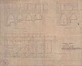 Plan and Sections of Church of St. John, Acre. 1927.jpg 8,686 × 7,048; 4.29 MB
-

-

-

-
 Dahr el-Omar's Wall. Crusader's Capital. Acre, Old City (SRF 5; 284).jpg 1,607 × 2,580; 1.16 MB
-
 Dahr el-Omar's Wall. Acre, Old City (SRF 5; 284).I.jpg 695 × 736; 153 KB
-
 Dahr el-Omar's Wall. Acre, Old City (SRF 5; 284).II.jpg 686 × 729; 187 KB
-
 Dahr el-Omar's Wall. Acre, Old City (SRF 5; 284).III.jpg 693 × 736; 181 KB
-
 Dahr el-Omar's Wall. Acre, Old City (SRF 5; 284).jpg 1,607 × 2,580; 1.1 MB
-
 Acre Citadel. Acre, Old City (SRF 5; 284).I.jpg 1,072 × 681; 245 KB
-
 Acre Citadel. Acre, Old City (SRF 5; 284).jpg 1,607 × 2,580; 1.22 MB
-
 Tower between 1935-1940. Acre, Old City (SRF 5; 284).jpg 785 × 1,261; 334 KB
-
 Sea Wall Facing Habour. Acre, Old City (SRF 5; 284).I.jpg 436 × 444; 64 KB
-
 Sea Wall Facing Habour. Acre, Old City (SRF 5; 284).II.jpg 440 × 442; 84 KB
-
 Sea Wall Facing Habour. Acre, Old City (SRF 5; 284).III.jpg 705 × 740; 123 KB
-
 Sea Wall Facing Habour. Acre, Old City (SRF 5; 284).jpg 1,613 × 2,600; 1.27 MB
-
 General view of Sea Wall. III. Acre, Old City (SRF 5; 284).I.jpg 1,312 × 943; 311 KB
-
 General view of Sea Wall. III. Acre, Old City (SRF 5; 284).II.jpg 1,318 × 940; 327 KB
-
 General view of Sea Wall. III. Acre, Old City (SRF 5; 284).jpg 1,613 × 2,600; 1.1 MB
-
 Habour El Manara. Tower of Flies .Acre, Old City (SRF 5; 284).jpg 698 × 728; 117 KB
-
 General view of Sea Wall. II.Acre, Old City (SRF 5; 284).I.jpg 1,308 × 726; 247 KB
-
 General view of Sea Wall. II.Acre, Old City (SRF 5; 284).II.jpg 1,305 × 796; 191 KB
-
 General view of Sea Wall. II.Acre, Old City (SRF 5; 284).III.jpg 1,322 × 775; 223 KB
-
 General view of Sea Wall. II.Acre, Old City (SRF 5; 284).jpg 1,620 × 2,580; 795 KB
-
 General view of Sea Wall. Acre, Old City (SRF 5; 284).I.jpg 724 × 574; 86 KB
-
 General view of Sea Wall. Acre, Old City (SRF 5; 284).II.jpg 721 × 673; 105 KB
-
 General view of Sea Wall. Acre, Old City (SRF 5; 284).jpg 1,592 × 2,580; 1.15 MB
-

-

-

-

-

-
 Acre City Walls (S) and Arches on Magistrate's Ct. Acre, Old City (SRF 5; 284).jpg 1,580 × 2,580; 1.22 MB
-
-

-

-

-

-

-

-

-

-

-

-

-

-

-
 Ruins of Bastion Tower from time of Daher al Omar. Acre, Old City (SRF 5; 284).jpg 1,587 × 2,600; 1.06 MB
-
 Turkish Arsenal Building. Acre, Old City (SRF 5; 284).I.jpg 1,071 × 615; 322 KB
-
 Turkish Arsenal Building. Acre, Old City (SRF 5; 284).II.jpg 1,072 × 614; 375 KB
-
 Turkish Arsenal Building. Acre, Old City (SRF 5; 284).III.jpg 1,068 × 605; 309 KB
-
 Turkish Arsenal Building. Acre, Old City (SRF 5; 284).jpg 1,600 × 2,587; 1.45 MB
-
 The Police station and Acre Wall. Acre, Old City (SRF 5; 284).I.jpg 1,081 × 641; 279 KB
-
 The Police station and Acre Wall. Acre, Old City (SRF 5; 284).II.jpg 616 × 1,149; 287 KB
-
 The Police station and Acre Wall. Acre, Old City (SRF 5; 284).III.jpg 620 × 1,137; 307 KB
-
 The Police station and Acre Wall. Acre, Old City (SRF 5; 284).jpg 2,587 × 1,600; 1.53 MB
-

-

-

-
 Remnant of Daher el Omar Wall. Acre, Old City (SRF 5; 284).jpg 1,627 × 2,580; 1.22 MB
-
 Inner Moat & Door. Acre, Old City (SRF 5; 284).jpg 614 × 816; 244 KB
-
 Inner Moat and Door. Acre, Old City (SRF 5; 284).jpg 1,607 × 2,580; 1.33 MB
-
 Dahr el-Omar's Wall. V. Acre, Old City (SRF 5; 284).I.jpg 704 × 732; 174 KB
-
 Dahr el-Omar's Wall. V. Acre, Old City (SRF 5; 284).II.jpg 702 × 734; 177 KB
-
 Dahr el-Omar's Wall. V. Acre, Old City (SRF 5; 284).III.jpg 697 × 732; 138 KB
-
 Dahr el-Omar's Wall. V. Acre, Old City (SRF 5; 284).jpg 2,580 × 1,607; 1.35 MB
-
 Dahr el-Omar's Wall. IV. Acre, Old City (SRF 5; 284).I.jpg 686 × 727; 157 KB
-
 Dahr el-Omar's Wall. IV. Acre, Old City (SRF 5; 284).II.jpg 672 × 727; 173 KB
-
 Dahr el-Omar's Wall. IV. Acre, Old City (SRF 5; 284).III.jpg 700 × 722; 159 KB
-
 Dahr el-Omar's Wall. IV. Acre, Old City (SRF 5; 284).jpg 1,607 × 2,580; 1.15 MB
-
 Dahr el-Omar's Wall. III. Acre, Old City (SRF 5; 284).I.jpg 683 × 718; 165 KB
-
 Dahr el-Omar's Wall. III. Acre, Old City (SRF 5; 284).II.jpg 694 × 727; 175 KB
-
 Dahr el-Omar's Wall. III. Acre, Old City (SRF 5; 284).III.jpg 706 × 717; 170 KB
-
 Dahr el-Omar's Wall. III. Acre, Old City (SRF 5; 284).jpg 1,607 × 2,580; 1.13 MB
-
 Dahr el-Omar's Wall. Vaults. Acre, Old City (SRF 5; 284).I.jpg 439 × 433; 58 KB
-
 Dahr el-Omar's Wall. Vaults. Acre, Old City (SRF 5; 284).II.jpg 437 × 431; 78 KB
-
 Dahr el-Omar's Wall. Vaults. Acre, Old City (SRF 5; 284).III.jpg 433 × 428; 73 KB
-
 Dahr el-Omar's Wall. Vaults. Acre, Old City (SRF 5; 284).jpg 1,607 × 2,580; 1.37 MB
-
 Dahr el-Omar's Wall. Inside face. Acre, Old City (SRF 5; 284).I.jpg 705 × 725; 211 KB
-
 Dahr el-Omar's Wall. Inside face. Acre, Old City (SRF 5; 284).II.jpg 706 × 726; 207 KB
-
 Dahr el-Omar's Wall. Inside face. Acre, Old City (SRF 5; 284).III.jpg 711 × 709; 238 KB
-
 Dahr el-Omar's Wall. Inside face. Acre, Old City (SRF 5; 284).jpg 1,607 × 2,580; 1.23 MB
-
 Dahr el-Omar's Wall. II. Acre, Old City (SRF 5; 284).I.jpg 711 × 730; 229 KB
-
 Dahr el-Omar's Wall. II. Acre, Old City (SRF 5; 284).II.jpg 684 × 724; 177 KB
-
 Dahr el-Omar's Wall. II. Acre, Old City (SRF 5; 284).III.jpg 689 × 723; 166 KB
-
 Dahr el-Omar's Wall. II. Acre, Old City (SRF 5; 284).jpg 1,607 × 2,580; 1.28 MB
-
 Wadi el-Mughara historic photos 09.jpg 3,264 × 4,928; 6.72 MB
-
 Wadi el-Mughara historic photos 01.jpg 3,370 × 2,227; 1.94 MB
-
 Wadi el-Mughara historic photos 02.jpg 4,928 × 3,264; 4.98 MB
-
 Wadi el-Mughara historic photos 05.jpg 3,264 × 4,928; 5.9 MB
-
 Wadi el-Mughara historic photos 10.jpg 3,264 × 4,928; 6.8 MB
-
 Wadi el-Mughara historic photos 03.jpg 1,345 × 2,181; 815 KB
-
 Wadi el-Mughara historic photos 04.jpg 2,033 × 1,327; 1.37 MB
-
 Wadi el-Mughara historic photos 08.jpg 3,264 × 4,928; 6.7 MB
-
 Wadi el-Mughara historic photos 06.jpg 4,928 × 3,264; 6.51 MB
-
 Wadi el-Mughara historic photos 07.jpg 3,264 × 4,928; 6.66 MB
-
 Wadi el-Mughara historic photos 11.jpg 3,264 × 4,928; 6.84 MB
-
 Tell Abu Zeitun (74135).I.jpg 1,172 × 884; 360 KB
-
 Tell Abu Zeitun (74135).II.jpg 1,554 × 919; 619 KB
-
 Tell Abu Zeitun (74135).III.jpg 1,567 × 651; 321 KB
-
 Tell Abu Zeitun (74135).jpg 3,264 × 4,928; 5.94 MB
-
 Tell Abu Zeitun (74136).I.jpg 1,561 × 945; 596 KB
-
 Tell Abu Zeitun (74136).II.jpg 1,558 × 933; 497 KB
-
 Tell Abu Zeitun (74136).jpg 3,264 × 4,928; 6.09 MB
-
 Tell Abu Hawam Plan 1932 (cropped).jpg 1,374 × 1,202; 495 KB
-
 Tell Abu Hawam Plan 1932 6030504-080100 001 000118.jpg 3,264 × 4,928; 5.75 MB
-
 Bnei Brak, Map of measuring plots. 1940.jpg 6,240 × 5,496; 2.58 MB
-
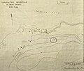 Chalcolithic Necropolis at Benei Beraq. Site plan.jpg 2,682 × 2,285; 2.12 MB
-
 Illustrated map of Benei Beraq including archaeological sites.jpg 2,872 × 2,811; 385 KB
-

-
 Tel Abel Beth Maacah, historical Image (1) (cropped).jpg 1,774 × 1,235; 1.11 MB
-
 Tel Abel Beth Maacah, historical Image (1).jpg 1,778 × 1,329; 1.2 MB
-
 Tel Abel Beth Maacah, historical Image - 1945 (cropped).jpg 1,773 × 1,312; 1.13 MB
-
 Tel Abel Beth Maacah, historical Image - 1945.jpg 1,800 × 1,450; 1.28 MB
-
 Tel Abel Beth Maacah, historical Image (2).jpg 1,379 × 1,005; 601 KB


.I.jpg)
.II.jpg)
.III.jpg)
.jpg)
.I.jpg)
.II.jpg)
.III.jpg)
.jpg)
.I.jpg)
.jpg)
.jpg)
.I.jpg)
.II.jpg)
.III.jpg)
.jpg)
.I.jpg)
.II.jpg)
.jpg)
.jpg)
.I.jpg)
.II.jpg)
.III.jpg)
.jpg)
.I.jpg)
.II.jpg)
.jpg)
_and_Arches_on_Magistrate%27s_Ct._Acre,_Old_City_(SRF_5;_284).I.jpg)
_and_Arches_on_Magistrate%27s_Ct._Acre,_Old_City_(SRF_5;_284).II.jpg)
_and_Arches_on_Magistrate%27s_Ct._Acre,_Old_City_(SRF_5;_284).III.jpg)
_and_Arches_on_Magistrate%27s_Ct._Acre,_Old_City_(SRF_5;_284).IV.jpg)
_and_Arches_on_Magistrate%27s_Ct._Acre,_Old_City_(SRF_5;_284).jpg)
_and_Arches_on_Magistrate%27s_Ct._Acre,_Old_City_(SRF_5;_284).VI.jpg)
_and_Arches_on_Magistrate%27s_Ct._Acre,_Old_City_(SRF_5;_284).VII.jpg)
_and_Arches_on_Magistrate%27s_Ct._Acre,_Old_City_(SRF_5;_284).VIII.jpg)
_and_Arches_on_Magistrate%27s_Ct._Acre,_Old_City_(SRF_5;_284).X.jpg)
_and_Arches_on_Magistrate%27s_Ct._Acre,_Old_City_(SRF_5;_284).XI.jpg)
_and_Arches_on_Magistrate%27s_Ct._Acre,_Old_City_(SRF_5;_284).XII.jpg)
_and_Arches_on_Magistrate%27s_Ct._Acre,_Old_City_(SRF_5;_284).XIII.jpg)
_and_Arches_on_Magistrate%27s_Ct._Acre,_Old_City_(SRF_5;_284).XV.jpg)
_and_Arches_on_Magistrate%27s_Ct._Acre,_Old_City_(SRF_5;_284).XVI.jpg)
.I.jpg)
.II.jpg)
.III.jpg)
.jpg)
.I.jpg)
.II.jpg)
.III.jpg)
.jpg)
.I.jpg)
.II.jpg)
.III.jpg)
.jpg)
.I.3129_Inner_moat,_inner_face_of_wall,_to_N.jpg)
.II.3130_Basement_of_tower_to_W.jpg)
.III.3131_Tower_to_W.jpg)
.jpg)
.jpg)
.jpg)
.I.jpg)
.II.jpg)
.III.jpg)
.jpg)
.I.jpg)
.II.jpg)
.III.jpg)
.jpg)
.I.jpg)
.II.jpg)
.III.jpg)
.jpg)
.I.jpg)
.II.jpg)
.III.jpg)
.jpg)
.I.jpg)
.II.jpg)
.III.jpg)
.jpg)
.I.jpg)
.II.jpg)
.III.jpg)
.jpg)


.I.jpg)
.II.jpg)
.III.jpg)
.jpg)
.I.jpg)
.II.jpg)
.jpg)
.jpg)


_(cropped).jpg)
.jpg)
.jpg)

.jpg)
_and_Arches_on_Magistrate%27s_Ct._Acre,_Old_City_(SRF_5;_284).IX.jpg)
_and_Arches_on_Magistrate%27s_Ct._Acre,_Old_City_(SRF_5;_284).V.jpg)
_and_Arches_on_Magistrate%27s_Ct._Acre,_Old_City_(SRF_5;_284).XIV.jpg)