Category:Images from Wiki Loves Earth 2024 by Ermell
Jump to navigation
Jump to search
Media in category "Images from Wiki Loves Earth 2024 by Ermell"
The following 111 files are in this category, out of 111 total.
-
 Bamberg Hain Hirschkäfer focus stacked-20240520-RM-103648.jpg 5,182 × 3,886; 6.54 MB
-
 Bamberg Rothof Linde-20170517-RM-153414.jpg 3,800 × 4,610; 15.87 MB
-
 Breitengüßbach Kiesgrube -20240505-RM-174717.jpg 5,184 × 3,888; 6.54 MB
-
 Breitengüßbach Kiesgrube Wellen -20240505-RM-174904.jpg 5,184 × 3,888; 6.65 MB
-
 Breitengüßbach Kiesgrube-20240505-RM-174914.jpg 5,121 × 3,841; 14.73 MB
-
 Bruderwald Bamberg-20141015-RM-095622.jpg 4,592 × 3,448; 16.82 MB
-
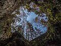
 Bruderwald Baum-20240510-RM-154657.jpg 3,248 × 2,961; 7.3 MB
-
 Bruderwald Baumstumpf-20240514-RM-162621.jpg 5,143 × 3,660; 12.14 MB
-
 Bruderwald Baumstumpf-20240525-RM-172126.jpg 3,602 × 2,756; 6.72 MB
-
 Bruderwald Birkenporling (Piptoporus betulinus) stacking-20201208-RM-105328.jpg 4,668 × 3,296; 6.15 MB
-
 Bruderwald Nebel Luftbild-20240210-RM-101617.jpg 5,082 × 3,806; 6.84 MB
-
 Bruderwald Nebel Luftbild-20240210-RM-101907.jpg 3,992 × 2,992; 4.74 MB
-
 Bruderwald Pilze verrottet-20201208-RM-103835.jpg 5,182 × 3,886; 10.31 MB
-
 Bösenbechhofen Weiher Kuckuck Cuculus canorus-20240608-RM-170659.jpg 1,643 × 2,191; 1.29 MB
-
 Bösenbechhofen Weiher Luftaufnahme-20240608-RM-162621.jpg 2,957 × 3,273; 6.82 MB
-
 Bösenbechhofen Weiher Luftaufnahme-20240608-RM-162650.jpg 4,777 × 3,577; 11.21 MB
-
 Bösenbechhofen Weiher Luftaufnahme-20240609-RM-000139.jpg 4,630 × 2,563; 6.35 MB
-
 Bösenbechhofen Weiher Orthophoto-20240608-RM-162739.jpg 5,272 × 3,948; 14.18 MB
-
 Bösenbechhofen Weiher Tafelente Aythya ferina Start-20240608-RM-160338.jpg 4,909 × 3,682; 8.64 MB
-
 Eggolsheim Naturschutzgebiet Büg -20240616-RM-162032.jpg 5,083 × 3,812; 16.2 MB
-
 Eggolsheim Naturschutzgebiet Büg -20240616-RM-162513.jpg 5,184 × 3,888; 15.84 MB
-
 Eggolsheim Naturschutzgebiet Büg -20240616-RM-163217.jpg 5,184 × 3,888; 25.34 MB
-
 Eggolsheim Naturschutzgebiet Büg -20240616-RM-163225.jpg 5,184 × 3,888; 20.6 MB
-
 Eggolsheim Naturschutzgebiet Büg -20240616-RM-163238.jpg 4,912 × 3,684; 20.97 MB
-
 Eggolsheim Naturschutzgebiet Büg -20240616-RM-163244.jpg 4,994 × 3,746; 17.01 MB
-
 Eggolsheim Naturschutzgebiet Büg -20240616-RM-163249.jpg 5,038 × 3,778; 17.28 MB
-
 Eggolsheim Naturschutzgebiet Büg -20240616-RM-163322.jpg 5,184 × 3,888; 21.93 MB
-
 Eggolsheim Naturschutzgebiet Büg -20240616-RM-163615.jpg 5,155 × 3,866; 23.56 MB
-
 Eggolsheim Naturschutzgebiet Büg -20240616-RM-164523.jpg 5,131 × 3,848; 14.11 MB
-
 Eggolsheim Naturschutzgebiet Büg -20240616-RM-164546.jpg 3,888 × 5,184; 15.3 MB
-
 Eggolsheim Naturschutzgebiet Büg -20240616-RM-164608.jpg 5,131 × 3,848; 12.97 MB
-
 Eggolsheim Naturschutzgebiet Büg -20240616-RM-164633.jpg 5,184 × 3,888; 13.97 MB
-
 Eggolsheim Naturschutzgebiet Büg -20240616-RM-165324.jpg 5,184 × 3,888; 12.72 MB
-
 Eggolsheim Naturschutzgebiet Büg -20240616-RM-171220.jpg 5,184 × 3,888; 18.53 MB
-
 Eggolsheim Naturschutzgebiet Büg -20240616-RM-171224.jpg 5,184 × 3,888; 19.13 MB
-
 Eggolsheim Naturschutzgebiet Büg Haubentaucher-20240622-RM-162508.jpg 2,698 × 2,024; 2.22 MB
-
 Eggolsheim Naturschutzgebiet Büg Haubentaucher-20240622-RM-162812.jpg 2,924 × 1,950; 2.2 MB
-
 Eggolsheim Naturschutzgebiet Büg Uferschwalben -20240622-RM-160605.jpg 2,567 × 1,925; 3.97 MB
-
 Eggolsheim Naturschutzgebiet Büg Uferschwalben -20240625-RM-120449.jpg 3,452 × 2,589; 4.65 MB
-
 Haubentaucher Eggolsheim Naturschutzgebiet Büg -20240616-RM-170326.jpg 3,128 × 2,138; 3.77 MB
-
 Haubentaucher Eggolsheim Naturschutzgebiet Büg -20240622-RM-155521.jpg 5,184 × 3,888; 5.69 MB
-
 Heiligenstadt Badesee Luftbild-20230928-RM-172028.jpg 4,945 × 3,477; 12.71 MB
-
 Hochstadt LSG Katzogel Luftbild-20240520-RM-164112.jpg 2,957 × 3,948; 8.99 MB
-
 Hochstadt LSG Katzogel Luftbild-20240520-RM-164126.jpg 4,175 × 3,041; 7.76 MB
-
 Hochstadt LSG Katzogel Luftbild-20240520-RM-164215.jpg 6,884 × 3,354; 19.89 MB
-
 Hochstadt LSG Katzogel-20240520-RM-163535.jpg 5,184 × 3,888; 13.04 MB
-
 Hochstadter See Luftbild-20240520-RM-160535.jpg 3,458 × 4,618; 10.64 MB
-
 Hochstadter See Luftbild-20240520-RM-160625.jpg 5,272 × 3,948; 8.3 MB
-
 Hohenhäusling Baum Winter-20130210-RM-145020.jpg 4,608 × 3,456; 5.98 MB
-
 Kitschentalrangen-20200629-RM-155820.jpg 3,869 × 5,174; 21.96 MB
-
 Memmelsdorf Schloss Seehof Lindenallee-20231101-RM-112503.jpg 5,184 × 3,888; 15.99 MB
-
 Memmelsdorf Schlossgarten Seehof Luftbild-20240412-RM-171016.jpg 4,168 × 3,343; 8.67 MB
-
 Naturschutzgebiet Büg Baggersee -20240622-RM-151959.jpg 5,184 × 3,888; 10.6 MB
-
 Naturschutzgebiet Büg Baggersee -20240622-RM-152005.jpg 5,184 × 3,888; 9.36 MB
-
 Naturschutzgebiet Büg Baggersee -20240622-RM-152848.jpg 5,184 × 3,888; 14.12 MB
-
 Naturschutzgebiet Büg Baggersee -20240622-RM-172051.jpg 5,184 × 3,888; 13.72 MB
-
 Naturschutzgebiet Büg Baggersee -20240622-RM-172103.jpg 5,184 × 3,888; 12.38 MB
-
 Naturschutzgebiet Büg Baggersee -20240622-RM-172121.jpg 5,184 × 3,888; 8.82 MB
-
 Naturschutzgebiet Büg Baggersee -20240622-RM-172144.jpg 5,184 × 3,888; 8.1 MB
-
 Naturschutzgebiet Büg Graureiher-20240625-RM-112816.jpg 4,970 × 3,522; 8.75 MB
-
 Naturschutzgebiet Büg Regnitz Altarm -20240622-RM-151350.jpg 5,184 × 3,888; 13.36 MB
-
 Naturschutzgebiet Büg Regnitz Altarm -20240622-RM-151400.jpg 5,184 × 3,888; 14.31 MB
-
 Naturschutzgebiet Büg Regnitz Altarm -20240622-RM-151408.jpg 5,184 × 3,888; 14.13 MB
-
 Naturschutzgebiet Büg Regnitz Altarm -20240622-RM-151733.jpg 5,184 × 3,888; 11.16 MB
-
 Naturschutzgebiet Büg Regnitz Altarm -20240622-RM-151737.jpg 5,184 × 3,888; 14.92 MB
-
 Naturschutzgebiet Büg Verbascum nigrum-20240622-RM-154202.jpg 3,888 × 5,184; 6.17 MB
-
 Naturschutzgebiet Büg-20240622-RM-152815.jpg 4,970 × 3,888; 14.82 MB
-
 Naturschutzgebiet Büg-20240622-RM-153012.jpg 5,184 × 3,888; 21.21 MB
-
 Naturschutzgebiet Büg-20240622-RM-153152.jpg 5,184 × 3,888; 19.16 MB
-
 Naturschutzgebiet Büg-20240622-RM-153234.jpg 5,184 × 3,888; 18.89 MB
-
 Naturschutzgebiet Büg-20240622-RM-153651.jpg 5,184 × 3,888; 18.01 MB
-
 Naturschutzgebiet Büg-20240622-RM-170146.jpg 5,184 × 3,888; 16.95 MB
-
 Naturschutzgebiet Büg-20240625-RM-113139.jpg 5,184 × 3,888; 12.54 MB
-
 Naturschutzgebiet Stocksee-20240618-RM-095218.jpg 5,184 × 3,888; 20.73 MB
-
 Naturschutzgebiet Stocksee-20240618-RM-095255.jpg 5,184 × 3,888; 21.63 MB
-
 Naturschutzgebiet Stocksee-20240618-RM-095357.jpg 3,888 × 5,184; 13.58 MB
-
 Naturschutzgebiet Stocksee-20240618-RM-095515.jpg 5,184 × 3,888; 12.64 MB
-
 Naturschutzgebiet Stocksee-20240618-RM-100619.jpg 5,184 × 3,888; 22.16 MB
-
 Naturschutzgebiet Stocksee-20240618-RM-100747.jpg 5,184 × 3,653; 18.79 MB
-
 Naturschutzgebiet Stocksee-20240618-RM-100927.jpg 5,184 × 3,888; 20.26 MB
-
 Neuenseer Weiher Luftbild-20240520-RM-165838.jpg 4,515 × 3,381; 10.22 MB
-
 Neuenseer Weiher Luftbild-20240520-RM-165843.jpg 5,272 × 3,414; 11.08 MB
-
 Neuenseer Weiher Luftbild-20240520-RM-165903.jpg 4,515 × 2,978; 7.06 MB
-
 Neuenseer Weiher Luftbild-20240520-RM-170043.jpg 2,774 × 3,948; 6.8 MB
-
 Neuenseer Weiher Luftbild-20240520-RM-170127.jpg 3,992 × 2,992; 7.98 MB
-
 Neuenseer Weiher Luftbild-20240520-RM-171024.jpg 3,287 × 3,948; 7.35 MB
-
 Neuenseer Weiher Orthophoto-20240520-RM-170218.jpg 5,272 × 3,948; 15.31 MB
-
 Neuenseer Weiher-20240520-RM-171945.jpg 5,184 × 3,888; 9.3 MB
-
 Neuenseer Weiher-20240520-RM-172003.jpg 5,144 × 3,858; 13.3 MB
-
 Neuenseer Weiher-20240520-RM-172130.jpg 5,138 × 3,854; 12.19 MB
-
 Neuenseer Weiher-20240520-RM-172151.jpg 5,045 × 3,784; 13.63 MB
-
 Neuenseer Weiher-20240520-RM-172339.jpg 5,184 × 3,888; 12 MB
-
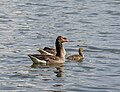 Neuhaus Graugansfamlie auf dem Großen Neuweiher-20240526-RM-165908.jpg 5,066 × 3,888; 6.84 MB
-
 Neuhaus Haubentaucher auf dem Großen Neuweiher-20240526-RM-164235.jpg 4,253 × 2,754; 3.41 MB
-
 Neuhaus Teich mit Vögeln-20240526-RM-171518.jpg 5,184 × 3,888; 11.14 MB
-
 Pulversee Seehof-20240618-RM-113045.jpg 5,184 × 3,888; 12.6 MB
-
 Pulversee Seehof-20240618-RM-113056.jpg 3,888 × 5,184; 14.11 MB
-
 Pulversee Seehof-20240618-RM-113210.jpg 5,184 × 3,888; 15.26 MB
-
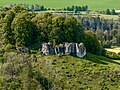
 Riesenburg HDR-20180418-RM-163651.jpg 5,166 × 3,875; 16.28 MB
-
 Schönbrunn Main Hochwasser Luftbild-20231228-RM-160846.jpg 5,272 × 3,948; 13.82 MB
-
 Schönbrunn Main Hochwasser Luftbild-20231228-RM-161017.jpg 5,272 × 3,948; 13.51 MB
-
 Seehof Altsee Haubentaucher-20240526-RM-122509.jpg 3,792 × 2,278; 2.85 MB
-
 Seehof Altsee Haubentaucherkücken-20240609-RM-113253.jpg 4,711 × 3,534; 4.49 MB
-
 Seigelstein Luftbild-20240512-RM-163822.jpg 3,992 × 2,992; 10.91 MB
-
 Spitzberg neben Staffelberg -20160814-RM-171328.jpg 3,051 × 3,941; 8.78 MB
-
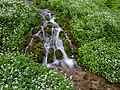 Tiefenellern Ellernbach Schaumkraut HRS-20240512-RM-172246.jpg 8,160 × 6,120; 24.26 MB
-
 Unterzaunsbach Felsen-20230709-RM-163449.jpg 5,272 × 3,948; 16.8 MB
-
 Weininsel Sommerach -20221027-RM-164202.jpg 3,312 × 4,416; 11.32 MB
-
 Weininsel Sommerach Luftbild-20221027-RM-155807.jpg 5,272 × 3,948; 18.11 MB
-
 Würgau Nebelstein Luftbild-20240331-RM-180234.jpg 3,566 × 2,992; 10.57 MB
-
 Würgau Nebelstein Panoroma Luftbild-20240331-RM-180328.jpg 9,115 × 2,608; 19.14 MB


_stacking-20201208-RM-105328.jpg)


