Category:Images by valenta
Jump to navigation
Jump to search

Media in category "Images by valenta"
The following 200 files are in this category, out of 200 total.
-
 36 Huntly Street (geograph 6030077).jpg 640 × 640; 116 KB
-
 Alness Viaduct (geograph 5885434).jpg 800 × 800; 262 KB
-
 Ardkeen Tower - Inverness (geograph 5706276).jpg 640 × 400; 71 KB
-
 Ardross Castle (geograph 4770934).jpg 4,426 × 3,319; 4.79 MB
-
 Avoch Parish Church (geograph 5577203).jpg 640 × 640; 140 KB
-
 Balblair Distillery (geograph 6074863).jpg 1,024 × 453; 124 KB
-
 Balnain House (geograph 6030063).jpg 512 × 640; 100 KB
-
 Belleport Pier (geograph 5482644).jpg 1,024 × 546; 134 KB
-
 Berriedale North Tower - Creag Na H-Atha (geograph 6217748).jpg 512 × 640; 106 KB
-
 Berriedale South Tower - Leac Ghlas (geograph 6217691).jpg 512 × 640; 98 KB
-
 Boath Doocot, Auldearn, Nairnshire - geograph-5524810.jpg 640 × 433; 95 KB
-
 Brackla Distillery (geograph 4527800).jpg 4,223 × 3,167; 4.45 MB
-
 Bridge Of Carron (geograph 4810444) (cropped).jpg 3,024 × 2,016; 2.61 MB
-
 Bridge Of Carron (geograph 4810444).jpg 4,751 × 3,563; 6.6 MB
-
 Brodie Castle Burial Ground (geograph 6229429).jpg 1,024 × 731; 396 KB
-
 Bryden Lodge (geograph 5716701).jpg 640 × 480; 80 KB
-
 Buldoo Bell Tower (geograph 5830234).jpg 1,024 × 731; 189 KB
-
 Cairn Irenan (geograph 5882609).jpg 800 × 571; 158 KB
-
 Carriblair Stone Circle (geograph 6075834).jpg 1,024 × 768; 279 KB
-
 Castle Bridge Forres (geograph 6051579).jpg 640 × 400; 80 KB
-
 Castle Leod (geograph 5819283).jpg 1,024 × 640; 221 KB
-
 Castle Leod (geograph 5819316).jpg 1,024 × 640; 255 KB
-
 Castle Leod (geograph 5819321).jpg 1,000 × 1,000; 334 KB
-
 Chapelton Bridge (geograph 5215139).jpg 640 × 480; 138 KB
-
 Clan Battle Monument above Clachnaharry (geograph 6363162).jpg 1,024 × 731; 369 KB
-
 Clan Battle Monument above Clachnaharry (geograph 6363171).jpg 1,024 × 768; 390 KB
-
 Clan Battle Monument above Clachnaharry (geograph 6363665).jpg 1,024 × 768; 210 KB
-
 Corrimony Falls (geograph 5031174).jpg 800 × 600; 265 KB
-
 Craigmin Bridge (geograph 5229829).jpg 640 × 480; 144 KB
-
 Cromarty - Dingwall Railway Bridge (geograph 5563335).jpg 640 × 342; 137 KB
-
 Cromarty - Dingwall Railway Bridge (geograph 6350045).jpg 1,024 × 768; 384 KB
-
 Cromarty - Dingwall Railway Bridge (geograph 6350048).jpg 800 × 600; 218 KB
-
 Cromarty Dingwall Railway Bridge (geograph 5563349).jpg 640 × 480; 126 KB
-
 Cromarty Dingwall Railway Bridge (geograph 5563364).jpg 640 × 480; 139 KB
-
 Cromarty Harbour (geograph 5938892).jpg 640 × 457; 89 KB
-
 Cromarty Pilot boarding the Northern Rock (geograph 5867890).jpg 1,600 × 1,000; 494 KB
-
 Cromarty Primary School (geograph 5650533).jpg 640 × 487; 82 KB
-
 Culloden House Gate Piers (geograph 5831794).jpg 1,024 × 731; 445 KB
-
 Culloden House Hotel (geograph 5831784).jpg 1,024 × 640; 200 KB
-
 Culloden House Stables (geograph 5848316).jpg 1,024 × 731; 339 KB
-
 Culloden House Stables (geograph 5848320).jpg 1,024 × 731; 363 KB
-
 Dalvey House (geograph 6295173).jpg 1,024 × 640; 205 KB
-
 Dalvey House (geograph 6295178).jpg 750 × 1,000; 139 KB
-
 Dalvey House (geograph 6295189).jpg 600 × 800; 134 KB
-
 Dalvey House (geograph 6295192).jpg 1,000 × 1,000; 218 KB
-
 Dalvey House (geograph 6295194).jpg 1,024 × 731; 202 KB
-
 Dalvey House, East Lodge (geograph 6297337).jpg 1,024 × 768; 327 KB
-
 Dingwall Town House (geograph 5674715).jpg 640 × 640; 85 KB
-
 Dingwall Town House Clock Tower (geograph 5815048).jpg 1,024 × 768; 115 KB
-
 Dipple Cemetery (geograph 4900185).jpg 4,896 × 3,672; 5.98 MB
-
 Dochgarroch Lock - Keeper's House (geograph 6212023).jpg 640 × 640; 132 KB
-
 Dornoch Mercat Cross (geograph 5782949).jpg 640 × 640; 163 KB
-
 Dovecot - Wester Elchies (geograph 4744188).jpg 2,048 × 1,536; 2.12 MB
-
 Druid Temple Chambered Cairn and Stone Circle (geograph 5607887).jpg 640 × 480; 186 KB
-
 EV Charging Points at The Storehouse (geograph 6442182).jpg 1,024 × 732; 219 KB
-
 Fairburn Estate access gate to the Orrin Reservoir road (geograph 5255396).jpg 1,600 × 1,000; 724 KB
-
 Fairburn Tower (geograph 5261744).jpg 640 × 554; 79 KB
-
 Fairburn Tower (geograph 5262721).jpg 640 × 400; 65 KB
-
 Ffordes Photographic Balblair (geograph 5320215).jpg 1,024 × 640; 224 KB
-
 Fields at Woodside (geograph 5267554).jpg 640 × 400; 72 KB
-
 Footbridge over the River Sgitheach (geograph 6558485).jpg 819 × 1,024; 208 KB
-
 Ford at the outflow of Loch Kemp (geograph 6381975).jpg 1,024 × 768; 291 KB
-
 Former Golspie Technical School Drummuie (geograph 5812749).jpg 1,200 × 1,600; 567 KB
-
 Former Goods Shed at Brora Station (geograph 6273279).jpg 640 × 480; 87 KB
-
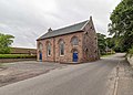
 Former Killearnan Free Church (geograph 6282595).jpg 800 × 1,000; 151 KB
-
 Former Rose Street Foundry Offices (geograph 5585827).jpg 1,024 × 640; 193 KB
-
 Former Royal Navy Fuel Depot (geograph 6014047).jpg 640 × 457; 138 KB
-
 Former Royal Navy Fuel Depot Pump House (geograph 6014040).jpg 1,024 × 768; 226 KB
-
 Former Town Hall and Playhouse Cinema (geograph 6016822).jpg 3,444 × 3,444; 4.02 MB
-
 Forres Market Green War Memorial (geograph 6047123).jpg 640 × 640; 156 KB
-
 Forres Tolbooth (geograph 5793129).jpg 480 × 640; 58 KB
-
 Forres Tolbooth (geograph 5926250).jpg 600 × 800; 143 KB
-
 Forres Tolbooth Prison cell (geograph 5926256).jpg 600 × 800; 102 KB
-
 Forteath Mausoleum (geograph 5270015).jpg 640 × 480; 130 KB
-
 Fortrose Town Hall (geograph 6212328).jpg 1,024 × 731; 215 KB
-
 Foulis Point Granary (geograph 5992227).jpg 640 × 400; 65 KB
-
 Garden in front of Dr Gray's Hospital (geograph 5622017).jpg 640 × 400; 76 KB
-
 Harbour Road Brora (geograph 6259555).jpg 512 × 640; 131 KB
-
 High Street Fortrose (geograph 6346955).jpg 800 × 800; 95 KB
-
 High Street Lossiemouth (geograph 6224429).jpg 1,024 × 640; 154 KB
-
 Highland Council Building at Drummuie (geograph 5808415).jpg 1,024 × 640; 188 KB
-
 Highland Council Building at Drummuie (geograph 5808428).jpg 640 × 640; 93 KB
-
 Highland Council Building at Drummuie (geograph 5808437).jpg 1,024 × 640; 184 KB
-
 Holm Mills Bridge (geograph 5641036).jpg 640 × 480; 93 KB
-
 Holm Mills Bridge (geograph 5713523).jpg 640 × 400; 69 KB
-
 Holm Mills Bridge (geograph 6047075).jpg 640 × 457; 97 KB
-
 Holm Mills Bridge and Lade (geograph 6047098).jpg 640 × 457; 88 KB
-
 Holme Rose (geograph 5226851).jpg 640 × 400; 115 KB
-
 Hugh Miller Monument (geograph 6061859).jpg 1,024 × 881; 186 KB
-
 Innes House Tower (geograph 6291465).jpg 800 × 1,000; 126 KB
-
 Invergordon Parish Church (geograph 6005764).jpg 800 × 800; 133 KB
-
 Invergordon Parish Church (geograph 6014013).jpg 640 × 480; 114 KB
-
 Inverness High School (geograph 6389599).jpg 1,500 × 938; 153 KB
-
 Inverness Town house (geograph 5647713).jpg 640 × 480; 117 KB
-
 Inverness Town house (geograph 5647716).jpg 640 × 480; 109 KB
-
 James Street Lossiemouth (geograph 6224389).jpg 640 × 800; 125 KB
-
 Keep the Pavement Dry (geograph 5065281).jpg 1,536 × 2,048; 1.23 MB
-
 Kildermorie Lodge (geograph 4770849).jpg 4,608 × 3,456; 6.03 MB
-
 Kiltearn Free Church Of Scotland (geograph 6125474).jpg 800 × 800; 111 KB
-
 Kiltearn Free Church Of Scotland (geograph 6125481).jpg 1,024 × 640; 145 KB
-
 Kirkton of Barevan (geograph 5668665).jpg 640 × 399; 116 KB
-
 Loch Duntelchaig Sunset (geograph 4921040).jpg 800 × 600; 95 KB
-
 Loch Kemp (geograph 6381978).jpg 1,024 × 768; 227 KB
-
 Loch Kemp (geograph 6381984).jpg 800 × 500; 75 KB
-
 Loch Kemp (geograph 6381994).jpg 800 × 600; 121 KB
-
 Loch Lundie (geograph 4935742).jpg 800 × 600; 218 KB
-
 Loch Lundie (geograph 5209676).jpg 640 × 480; 112 KB
-
 Loch Lundie (geograph 5452042).jpg 1,024 × 555; 211 KB
-
 Lovat Scout Memorial (geograph 5664198).jpg 1,024 × 649; 197 KB
-
 Lybster Harbour (geograph 5843022).jpg 1,600 × 1,000; 1.7 MB
-
 Lybster Harbour (geograph 5848084).jpg 800 × 571; 101 KB
-
 Lybster Harbour (geograph 5855152).jpg 1,024 × 640; 190 KB
-
 Lybster Harbour Entrance.jpg 800 × 600; 136 KB
-
 Lybster Harbour Slipways (geograph 5845790).jpg 640 × 400; 75 KB
-
 Mechanics' Institute Forres (geograph 5748830).jpg 640 × 640; 109 KB
-
 Memorial by the roadside at Raigbeg (geograph 5942612).jpg 800 × 800; 304 KB
-
 Memorial Cottages below Lady Hill (geograph 5632221).jpg 640 × 400; 77 KB
-
 Milton Market Cross (geograph 5317622).jpg 3,456 × 4,608; 5.64 MB
-
 Miltonduff Doocot (geograph 6197861).jpg 640 × 480; 129 KB
-
 Moray Coast Trail (geograph 5693033).jpg 640 × 480; 96 KB
-
 Moy Bridge (geograph 4808490).jpg 4,896 × 3,672; 4.18 MB
-
 Mulbuie Community Hall (geograph 6299796).jpg 1,024 × 731; 209 KB
-
 Nairn Town House (geograph 6434814).jpg 1,024 × 838; 197 KB
-
 Nairn Town House Renovations (geograph 6436482).jpg 800 × 1,000; 255 KB
-
 New Houses North Kessock (geograph 5845355).jpg 1,024 × 731; 289 KB
-
 Northern Rock - Nigg Graving Dock (geograph 5867828).jpg 1,024 × 768; 207 KB
-
 Obelisk To Earl Of Cromarty (geograph 5992252).jpg 640 × 640; 68 KB
-
 Old Bridge over River Oich (geograph 6064576).jpg 1,024 × 731; 312 KB
-
 Old Kiltearn Parish Church (geograph 5339594).jpg 480 × 640; 104 KB
-
 Old Kiltearn Parish Church (geograph 5368751).jpg 640 × 400; 72 KB
-
 Old railway fence strainer post (geograph 5563319).jpg 600 × 800; 316 KB
-
 Pace Cafe and Library Ardersier (geograph 5793109).jpg 1,024 × 640; 233 KB
-
 Palace of Spynie (geograph 5673052).jpg 640 × 422; 93 KB
-
 Panoramic view over Dingwall and the inner Cromarty Firth (geograph 5620475).jpg 1,024 × 419; 104 KB
-
 Parkhill Railway Bridge over the Balnagown River (geograph 6006787).jpg 640 × 480; 126 KB
-
 Parliamentary bridge over the Black Water (geograph 5794148).jpg 1,024 × 768; 271 KB
-
 Path leading up to Birnie Kirk (geograph 5264256).jpg 600 × 800; 150 KB
-
 Petty Church - Watch House (geograph 6511850).jpg 768 × 1,024; 204 KB
-
 Petty Church - Watch House (geograph 6511856).jpg 1,024 × 1,024; 327 KB
-
 Plaque on the Royal Northern Infirmary (geograph 5716691).jpg 640 × 480; 74 KB
-
 Pond Teaninich (geograph 5900512).jpg 1,024 × 768; 330 KB
-
 Redcastle Burn (geograph 6399396).jpg 1,024 × 683; 310 KB
-
 River Sgitheach (geograph 6558482).jpg 819 × 1,024; 192 KB
-
 Rosemarkie Groam House Museum (geograph 6212352).jpg 1,024 × 640; 185 KB
-
 Rosemarkie High Street (geograph 5997323).jpg 800 × 600; 117 KB
-
 Rosemarkie Parish Church (geograph 6212334).jpg 800 × 800; 153 KB
-
 Rosemarkie Parish Church (geograph 6212357).jpg 640 × 800; 206 KB
-
 Royal Hotel Cromarty (geograph 5654447).jpg 640 × 400; 74 KB
-
 Santa Fe No 98 (geograph 6480841).jpg 1,000 × 714; 270 KB
-
 Scottish Highlander (geograph 6158928).jpg 640 × 480; 57 KB
-
 Sea Defences Alness Point (geograph 5864652).jpg 1,024 × 640; 149 KB
-
 Shop front High Street Cromarty (geograph 5658033).jpg 640 × 480; 100 KB
-
 St Andrew's Well - Chapelton Bridge (geograph 6311428).jpg 800 × 600; 231 KB
-
 St Barevan's Church (geograph 5668672).jpg 640 × 412; 109 KB
-
 St Duthac's Church Graveyard (geograph 5367924).jpg 1,024 × 768; 234 KB
-
 St John's Episcopal church Arpafeelie (geograph 6052828).jpg 640 × 457; 107 KB
-
 Stone Circle - Knock of Alves (geograph 5265076).jpg 640 × 480; 154 KB
-
 Stone detail Avoch Parish Church (geograph 5617370).jpg 750 × 1,000; 110 KB
-
 Stone detail Avoch Parish Church (geograph 5617567).jpg 1,024 × 768; 144 KB
-
 Stone detail Avoch Parish Church (geograph 5617570).jpg 1,024 × 768; 188 KB
-
 Strathdearn War Memorial (geograph 6021682).jpg 640 × 800; 238 KB
-
 Tarbat House (geograph 5299647).jpg 640 × 400; 99 KB
-
 Tarbat House (geograph 5480372).jpg 1,024 × 640; 225 KB
-
 Tarbat House (geograph 6547874).jpg 1,024 × 768; 214 KB
-
 Teaninich Distillery (geograph 5873345).jpg 800 × 500; 122 KB
-
 Teaninich Distillery (geograph 5900510).jpg 1,024 × 731; 227 KB
-
 The A9 Berriedale Braes Improvement Works (geograph 6255390).jpg 640 × 480; 108 KB
-
 The Anderson Hotel Fortrose (geograph 6346980).jpg 800 × 800; 78 KB
-
 The Carnegie Links (geograph 5359846).jpg 1,024 × 640; 176 KB
-
 The Gaelic Chapel (geograph 6061850).jpg 640 × 480; 135 KB
-
 The Gaelic Chapel (geograph 6061852).jpg 512 × 640; 121 KB
-
 The Gaelic Chapel Cemetery (geograph 6119256).jpg 1,024 × 640; 201 KB
-
 The Highland Council HQ - Glenurquhart Road (geograph 4942622).jpg 4,608 × 3,456; 4.85 MB
-
 The Hugh Miller Institute on Church Street (geograph 6096942).jpg 800 × 600; 156 KB
-
 The Knocknagael Boarstone (geograph 4942628).jpg 4,608 × 3,456; 5.88 MB
-
 The Muir Hub (geograph 5845754).jpg 1,400 × 1,000; 397 KB
-
 The North Kessock Hotel (geograph 5668698).jpg 1,024 × 640; 186 KB
-
 The Old Brewery (geograph 6062209).jpg 640 × 457; 94 KB
-
 The Paye - Cromarty (geograph 6060646).jpg 800 × 800; 193 KB
-
 The White Bridge (geograph 6171197).jpg 800 × 500; 106 KB
-
 The White Bridge (geograph 6171460).jpg 800 × 571; 133 KB
-
 The White Bridge over the River Nairn (geograph 6171461).jpg 640 × 480; 112 KB
-
 Tiled Arch former Rose Street Foundry Offices (geograph 5585851).jpg 1,024 × 768; 282 KB
-
 Tiled Arch former Rose Street Foundry Offices (geograph 5585857).jpg 1,024 × 768; 272 KB
-
 Town House - Lossiemouth (geograph 5755691).jpg 480 × 640; 59 KB
-
 Townlands Barn - Cromarty (geograph 6062217).jpg 1,024 × 640; 236 KB
-
 Townlands Barn - Cromarty (geograph 6062221).jpg 1,500 × 938; 360 KB
-
 Victoria Jubilee drinking fountain (geograph 6096950).jpg 480 × 640; 114 KB
-
 View across the fields to Drummuie (geograph 6183922).jpg 800 × 600; 155 KB
-
 View over the Dalneigh area of Inverness (geograph 6375962).jpg 1,024 × 602; 174 KB
-
 Watch House Latheron Old Parish Church (geograph 5842055).jpg 1,024 × 731; 207 KB
-
 Weather Vane Avoch Parish Church (geograph 5760624).jpg 480 × 640; 23 KB
-
 Weather Vane on Bryden Lodge (geograph 5716696).jpg 480 × 640; 44 KB
-
 Weather Vane on Dornoch Cathedral (geograph 5782899).jpg 512 × 640; 53 KB
-
 Weir and Bridge over the Muckle Burn (geograph 6295220).jpg 640 × 480; 139 KB
-
 West side of the old Golspie Technical School (geograph 5808443).jpg 1,024 × 640; 207 KB
-
 Wind Turbine Towers - Nigg Energy Park (geograph 5867799).jpg 750 × 1,000; 247 KB
-
 Wyvis Lodge - Loch Glass (geograph 5345956).jpg 1,024 × 793; 224 KB
-
 York Tower (geograph 5266660).jpg 479 × 640; 70 KB
-
 York Tower Detail - geograph.org.uk - 5266680.jpg 1,024 × 792; 287 KB
.jpg)
.jpg)
.jpg)
.jpg)
.jpg)
.jpg)
.jpg)
.jpg)
.jpg)
.jpg)

.jpg)
_(cropped).jpg)
.jpg)
.jpg)
.jpg)
.jpg)
.jpg)
.jpg)
.jpg)
.jpg)
.jpg)
.jpg)
.jpg)
.jpg)
.jpg)
.jpg)
.jpg)
.jpg)
.jpg)
.jpg)
.jpg)
.jpg)
.jpg)
.jpg)
.jpg)
.jpg)
.jpg)
.jpg)
.jpg)
.jpg)
.jpg)
.jpg)
.jpg)
.jpg)
.jpg)
.jpg)
.jpg)
.jpg)
.jpg)
.jpg)
.jpg)
.jpg)
.jpg)
.jpg)
.jpg)
.jpg)
.jpg)
.jpg)
.jpg)
.jpg)
.jpg)
.jpg)
.jpg)
.jpg)
.jpg)
.jpg)
.jpg)
.jpg)
.jpg)
.jpg)
.jpg)
.jpg)
.jpg)
.jpg)
.jpg)
.jpg)
.jpg)
.jpg)
.jpg)
.jpg)
.jpg)
.jpg)
.jpg)
.jpg)
.jpg)
.jpg)
.jpg)
.jpg)
.jpg)
.jpg)
.jpg)
.jpg)
.jpg)
.jpg)
.jpg)
.jpg)
.jpg)
.jpg)
.jpg)
.jpg)
.jpg)
.jpg)
.jpg)
.jpg)
.jpg)
.jpg)
.jpg)
.jpg)
.jpg)
.jpg)
.jpg)

.jpg)
.jpg)
.jpg)
.jpg)
.jpg)
.jpg)
.jpg)
.jpg)
.jpg)
.jpg)
.jpg)
.jpg)
.jpg)
.jpg)
.jpg)
.jpg)
.jpg)
.jpg)
.jpg)
.jpg)
.jpg)
.jpg)
.jpg)
.jpg)
.jpg)
.jpg)
.jpg)
.jpg)
.jpg)
.jpg)
.jpg)
.jpg)
.jpg)
.jpg)
.jpg)
.jpg)
.jpg)
.jpg)
.jpg)
.jpg)
.jpg)
.jpg)
.jpg)
.jpg)
.jpg)
.jpg)
.jpg)
.jpg)
.jpg)
.jpg)
.jpg)
.jpg)
.jpg)
.jpg)
.jpg)
.jpg)
.jpg)
.jpg)
.jpg)
.jpg)
.jpg)
.jpg)
.jpg)
.jpg)
.jpg)
.jpg)
.jpg)
.jpg)
.jpg)
.jpg)
.jpg)
.jpg)
.jpg)
.jpg)
.jpg)
.jpg)
.jpg)
.jpg)
.jpg)
.jpg)
.jpg)
.jpg)
.jpg)
.jpg)
.jpg)

.jpg)