Category:Images by Ron Strutt
Jump to navigation
Jump to search

Media in category "Images by Ron Strutt"
The following 200 files are in this category, out of 773 total.
(previous page) (next page)-
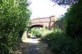
 A bridge within a bridge near Bramley - geograph.org.uk - 44462.jpg 640 × 439; 117 KB
-
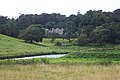
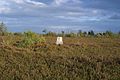
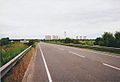
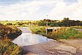
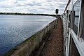
 A changing landscape - geograph.org.uk - 49753.jpg 640 × 427; 159 KB
-
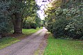
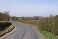 A country lane near Old Mill Farm - geograph.org.uk - 48311.jpg 640 × 427; 73 KB
-
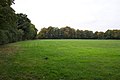
 A glimpse of Stanley Pool - geograph.org.uk - 49706.jpg 640 × 427; 115 KB
-
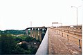
 A mystery near Kemsing, Kent - geograph.org.uk - 41978.jpg 640 × 427; 117 KB
-
 A rather small place^ - geograph.org.uk - 44106.jpg 640 × 427; 77 KB
-
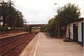
 A reminder of Braunton's railway - geograph.org.uk - 42697.jpg 640 × 427; 116 KB
-
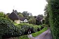
 A superb example of the thatcher's art - geograph.org.uk - 46256.jpg 640 × 427; 117 KB
-
 A303 near Forton - geograph.org.uk - 62377.jpg 640 × 427; 74 KB
-
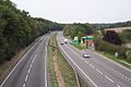
 A38 Flyover - geograph.org.uk - 43444.jpg 640 × 427; 72 KB
-
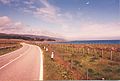 A9 north of Brora.jpg 640 × 434; 75 KB
-
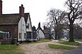
 Abbotsbury village - geograph.org.uk - 46358.jpg 640 × 427; 95 KB
-
 Alfold village centre - geograph.org.uk - 40245.jpg 640 × 427; 90 KB
-
 All Souls church, Sutton Green - geograph.org.uk - 53405.jpg 640 × 427; 112 KB
-
 Anchored on the Taw - geograph.org.uk - 42700.jpg 640 × 427; 57 KB
-
 Anglo-Saxon village at West Stow - geograph.org.uk - 40260.jpg 640 × 427; 123 KB
-
 Anneka's Bridge - geograph.org.uk - 43657.jpg 640 × 427; 71 KB
-
 Appledore, Devon - geograph.org.uk - 43094.jpg 640 × 427; 63 KB
-
 Approach to HMP Coldingley - geograph.org.uk - 58988.jpg 640 × 427; 107 KB
-
 Ardnamurchan lighthouse - geograph.org.uk - 43803.jpg 431 × 640; 57 KB
-
 Argos Hill Mill.jpg 427 × 640; 76 KB
-
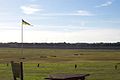
 Army training area - geograph.org.uk - 49726.jpg 640 × 427; 111 KB
-
 Army training area on Cleygate Common - geograph.org.uk - 49745.jpg 640 × 427; 138 KB
-
 Ash Vale station and bridge - geograph.org.uk - 55848.jpg 640 × 427; 79 KB
-
 Ash Wharf - geograph.org.uk - 55857.jpg 640 × 427; 83 KB
-
 Ash Wharf - geograph.org.uk - 55868.jpg 640 × 427; 86 KB
-

-
 Ashford Hospital - geograph.org.uk - 45034.jpg 640 × 427; 81 KB
-
 Ashington - geograph.org.uk - 52004.jpg 640 × 427; 87 KB
-
 Ashley church - geograph.org.uk - 44110.jpg 640 × 427; 77 KB
-
 Attleborough railway station 1.jpg 640 × 427; 100 KB
-
 Avebury Down - geograph.org.uk - 44039.jpg 640 × 427; 61 KB
-
 Ball clay works at West Bear - geograph.org.uk - 43115.jpg 640 × 427; 86 KB
-
 Banham, Norfolk - geograph.org.uk - 42068.jpg 640 × 427; 141 KB
-
 Baptist church at Wellow - geograph.org.uk - 62583.jpg 427 × 640; 60 KB
-
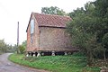
 Barn on Brook Down - geograph.org.uk - 62551.jpg 640 × 427; 57 KB
-
 Barnham, Suffolk - geograph.org.uk - 42089.jpg 640 × 427; 122 KB
-
 Barns at East Afton Farm - geograph.org.uk - 62557.jpg 640 × 427; 60 KB
-
 Barnstaple Bay - geograph.org.uk - 42694.jpg 640 × 427; 38 KB
-
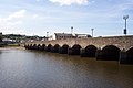 Barnstaplelongbridge.jpg 640 × 427; 68 KB
-
 Bath Green Park railway station.jpg 640 × 427; 107 KB
-
 Bayham Abbey.jpg 640 × 427; 84 KB
-
 Baynards Railway Station.jpg 640 × 427; 118 KB
-
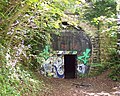
 Baynards Tunnel.jpg 640 × 427; 135 KB
-
 Beach at Norman's Bay - geograph.org.uk - 42056.jpg 640 × 427; 76 KB
-
 Bear's Down wind farm - geograph.org.uk - 43716.jpg 640 × 427; 46 KB
-
 Believe it or not^ - geograph.org.uk - 46633.jpg 640 × 427; 113 KB
-
 Bideford station - geograph.org.uk - 43096.jpg 640 × 427; 77 KB
-
 Bintry (or Bintree) Mill, Norfolk - geograph.org.uk - 46615.jpg 562 × 377; 77 KB
-
 Bisley church - geograph.org.uk - 58872.jpg 640 × 427; 133 KB
-
 Bisley Rifle Ranges - geograph.org.uk - 52076.jpg 640 × 427; 55 KB
-
 Bisley Village Green - geograph.org.uk - 58888.jpg 640 × 427; 101 KB
-
 Bissoe - geograph.org.uk - 43573.jpg 640 × 427; 75 KB
-
 Black Dog Halt, near Calne, Wilts - geograph.org.uk - 40305.jpg 640 × 427; 131 KB
-
 Blacksmiths Arms, Isle of Wight - geograph.org.uk - 62608.jpg 640 × 427; 75 KB
-
 Bodmin Gaol - geograph.org.uk - 43649.jpg 640 × 427; 92 KB
-
 Bodmin station and signalbox - geograph.org.uk - 43647.jpg 640 × 427; 122 KB
-
 St Botolph's church, Botesdale, Suffolk - geograph.org.uk - 40521.jpg 640 × 427; 127 KB
-
 Bournemouth beach and pier - geograph.org.uk - 46470.jpg 640 × 427; 65 KB
-
 Bowcombe Methodist church - geograph.org.uk - 62510.jpg 640 × 427; 87 KB
-
 Bramley & Wonersh Station 1.jpg 640 × 427; 105 KB
-
 Braunton Village.jpg 640 × 427; 113 KB
-
-
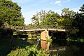
 Bridge at Brandy Hole Copse - geograph.org.uk - 48322.jpg 640 × 427; 143 KB
-
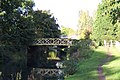
 Bridge at Run Common - geograph.org.uk - 48522.jpg 640 × 427; 129 KB
-
 Bridge of Oich - geograph.org.uk - 52247.jpg 640 × 427; 73 KB
-
 Bridge over Blackhorse Road - geograph.org.uk - 45710.jpg 640 × 427; 111 KB
-

-
 Bridge over the River Avon - geograph.org.uk - 44122.jpg 640 × 427; 137 KB
-
 Bridge over the River Avon, Chippenham - geograph.org.uk - 44056.jpg 640 × 427; 132 KB
-
 Bridges at Clay Lane - geograph.org.uk - 60522.jpg 640 × 427; 108 KB
-
 Bridley Manor - geograph.org.uk - 45789.jpg 640 × 427; 112 KB
-
 Brittas Bay.jpg 640 × 425; 47 KB
-
 Broadmead Bridge - geograph.org.uk - 60673.jpg 640 × 427; 108 KB
-
 Broadoak Bridge and weir - geograph.org.uk - 60537.jpg 640 × 427; 114 KB
-
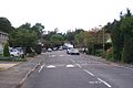
 Broadstone, Dorset - geograph.org.uk - 42669.jpg 640 × 427; 72 KB
-
 Brookwood Cemetery - geograph.org.uk - 45777.jpg 640 × 427; 117 KB
-
 Bures Mill, near Bures, Suffolk - geograph.org.uk - 40555.jpg 640 × 427; 110 KB
-
 Burnham Market - geograph.org.uk - 46622.jpg 570 × 379; 77 KB
-
 Bus shelters on Kingfield Green, Woking - geograph.org.uk - 41052.jpg 640 × 427; 133 KB
-
 Byfleet Manor - geograph.org.uk - 44436.jpg 640 × 431; 63 KB
-
 Byway through the Woods - geograph.org.uk - 44336.jpg 640 × 427; 141 KB
-
 Caerhays Castle - geograph.org.uk - 43585.jpg 640 × 427; 83 KB
-
 Winkle Street, Calbourne - geograph.org.uk - 62602.jpg 640 × 427; 92 KB
-
 Calne, Wiltshire - geograph.org.uk - 44030.jpg 640 × 427; 65 KB
-
 Canal and Railway at Little Bedwyn - geograph.org.uk - 47246.jpg 578 × 386; 68 KB
-
 Cann Quarry - geograph.org.uk - 43427.jpg 640 × 427; 135 KB
-
 Catholic church at Send - geograph.org.uk - 63417.jpg 450 × 300; 37 KB
-
 Causeway Lake, Newtown - geograph.org.uk - 62495.jpg 640 × 427; 38 KB
-
 Channel Tunnel Rail Link - geograph.org.uk - 41960.jpg 640 × 427; 84 KB
-
 Channel Tunnel Rail Terminal - geograph.org.uk - 41751.jpg 640 × 427; 71 KB
-

-
 Charterhouseleadmines.jpg 587 × 395; 53 KB
-
 Cherhill village - geograph.org.uk - 46640.jpg 640 × 427; 101 KB
-
 Cheverton Farm - geograph.org.uk - 62515.jpg 640 × 427; 91 KB
-
 Chivenor airfield - geograph.org.uk - 42698.jpg 640 × 427; 59 KB
-

-
 Church at Cockley Cley - geograph.org.uk - 46589.jpg 640 × 427; 73 KB
-
 Church at St Mary in the Marsh - geograph.org.uk - 41696.jpg 640 × 427; 85 KB
-
 Church Street, Old Woking - geograph.org.uk - 60672.jpg 640 × 427; 84 KB
-
 Clamerkin Lake - geograph.org.uk - 62501.jpg 640 × 427; 98 KB
-
 Cobbett Hill Radio Station - geograph.org.uk - 57338.jpg 640 × 427; 112 KB
-
 Cobbett Hill Radio Station - geograph.org.uk - 57348.jpg 640 × 427; 140 KB
-
 Colony Bog - geograph.org.uk - 59617.jpg 640 × 427; 127 KB
-
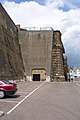
 Combe Down Tunnel, near Bath - geograph.org.uk - 41502.jpg 498 × 397; 151 KB
-
 Corfe Castle - geograph.org.uk - 46432.jpg 640 × 427; 89 KB
-
 Cottage near Holtye, Kent-Sussex border - geograph.org.uk - 42065.jpg 640 × 427; 133 KB
-
 Country bridge near Trewerry Mill, Trerice - geograph.org.uk - 43736.jpg 640 × 427; 138 KB
-
 Country junction - geograph.org.uk - 62500.jpg 640 × 427; 93 KB
-
 Country lane at Trevengenow - geograph.org.uk - 43721.jpg 640 × 427; 65 KB
-
 Cowlands Creek - geograph.org.uk - 43581.jpg 640 × 427; 74 KB
-
 Crastock Manor - geograph.org.uk - 45802.jpg 640 × 427; 98 KB
-
 Croyde, North Devon - geograph.org.uk - 42692.jpg 640 × 427; 90 KB
-
 Cuckoo Trail Footpath.jpg 640 × 427; 124 KB
-
 Cudworth manor house, Surrey - geograph.org.uk - 40424.jpg 640 × 427; 121 KB
-
-
 Cycle path sculpture at Fishbourne - geograph.org.uk - 48319.jpg 640 × 427; 130 KB
-
 Cycle path sculpture at Lavant - geograph.org.uk - 48323.jpg 640 × 427; 97 KB
-
 Cycling near Newham - geograph.org.uk - 43580.jpg 640 × 427; 139 KB
-
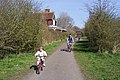
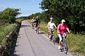 Cyclists on the Tarka Trail - geograph.org.uk - 42702.jpg 640 × 427; 115 KB
-
 Danger Area^ - geograph.org.uk - 58512.jpg 640 × 427; 103 KB
-
 Dartmoor Leat - geograph.org.uk - 43160.jpg 640 × 427; 102 KB
-
 Deal Castle.jpg 640 × 427; 89 KB
-
 Deal Pier, Kent - geograph.org.uk - 41824.jpg 640 × 427; 71 KB
-
 Deal Timeball Tower.jpg 427 × 640; 64 KB
-
 Deepcut Army Camp - geograph.org.uk - 59426.jpg 640 × 427; 63 KB
-
 Demolished bridge over the River Wey - geograph.org.uk - 48515.jpg 640 × 427; 140 KB
-
 Derriton Railway Viaduct.jpg 640 × 412; 52 KB
-
 Diss, Norfolk - geograph.org.uk - 42094.jpg 640 × 427; 71 KB
-
 Disused railway crosses railway - geograph.org.uk - 47837.jpg 640 × 427; 153 KB
-
-
 Dollands Moor Freight Terminal - geograph.org.uk - 41741.jpg 640 × 427; 81 KB
-
 Dover Castle - geograph.org.uk - 41764.jpg 640 × 427; 62 KB
-
 Dover Harbour and breakwater - geograph.org.uk - 41783.jpg 640 × 427; 59 KB
-
 Downpatrick Railway Museum - geograph.org.uk - 50902.jpg 640 × 425; 64 KB
-
 Drax power station - geograph.org.uk - 56480.jpg 640 × 436; 60 KB
-
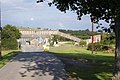
 Drive to Sutton Place - geograph.org.uk - 60615.jpg 640 × 427; 126 KB
-
 Egbury hillfort - geograph.org.uk - 62246.jpg 640 × 427; 70 KB
-
 Egbury hillfort - geograph.org.uk - 62250.jpg 640 × 427; 141 KB
-
 Elvanfoot - geograph.org.uk - 56529.jpg 640 × 431; 79 KB
-
 Elveden church - geograph.org.uk - 44069.jpg 427 × 640; 82 KB
-
 End of the summer on the Wey Navigation - geograph.org.uk - 60424.jpg 640 × 427; 107 KB
-
 Energy conservation in Woking - geograph.org.uk - 45728.jpg 640 × 427; 87 KB
-
 Erskine Bridge - geograph.org.uk - 43920.jpg 640 × 432; 52 KB
-
 Erskine Bridge - geograph.org.uk - 43980.jpg 640 × 427; 43 KB
-
 Estuary of the River Exe - geograph.org.uk - 43739.jpg 640 × 427; 45 KB
-
 Euston, Suffolk - geograph.org.uk - 42081.jpg 640 × 427; 101 KB
-
 Evesham Abbey Almonry.jpg 640 × 427; 112 KB
-
 Evesham railway station - geograph.org.uk - 40286.jpg 640 × 427; 103 KB
-
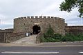
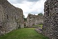 Eynsford Castle, Kent - geograph.org.uk - 40563.jpg 640 × 427; 119 KB
-
 Factory at Ilfracombe old station - geograph.org.uk - 58692.jpg 640 × 427; 123 KB
-
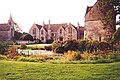
 Farringford - geograph.org.uk - 62406.jpg 640 × 427; 72 KB
-
 Faslane naval base - geograph.org.uk - 52237.jpg 640 × 425; 50 KB
-
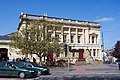
 Faversham market - geograph.org.uk - 41925.jpg 640 × 427; 82 KB
-
-
 Fields at Wood Street Village - geograph.org.uk - 58229.jpg 640 × 427; 81 KB
-
 Fields near Charndon, Bucks - geograph.org.uk - 41116.jpg 640 × 427; 51 KB
-
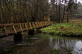 Footbridge and ford at Tankersford - geograph.org.uk - 40456.jpg 640 × 427; 121 KB
-
 Ford and bridge on Bodmin Moor - geograph.org.uk - 47256.jpg 591 × 395; 67 KB
-
 Ford at Carisbrooke - geograph.org.uk - 62505.jpg 640 × 427; 145 KB
-
 Ford at Clatterford Shute - geograph.org.uk - 62506.jpg 640 × 427; 121 KB
-
 Ford near Legonna - geograph.org.uk - 43731.jpg 640 × 427; 133 KB
-
 Former barracks sports ground - geograph.org.uk - 59441.jpg 640 × 427; 85 KB
-
 Fremington Station on the Tarka Trail - geograph.org.uk - 43082.jpg 640 × 427; 79 KB
-
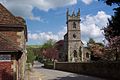
 Freshwater church - geograph.org.uk - 62563.jpg 640 × 427; 95 KB
-
 Frimley Aqueduct - geograph.org.uk - 59454.jpg 640 × 427; 108 KB
-
 Frog Grove Lane - geograph.org.uk - 58237.jpg 640 × 427; 110 KB
-
 Goldsworth Park Centre - geograph.org.uk - 45731.jpg 640 × 427; 92 KB
-
 Gorey4.jpg 640 × 425; 69 KB
-
 Goudhurst, Kent - geograph.org.uk - 41629.jpg 640 × 427; 80 KB
-
 Granary at Apesdown - geograph.org.uk - 62616.jpg 640 × 427; 95 KB
-
-
 Great Wishford church - geograph.org.uk - 44136.jpg 640 × 427; 89 KB
-
 Grenofen Bridge - geograph.org.uk - 43155.jpg 640 × 427; 145 KB
-
 Grimes Graves, near Thetford, Norfolk - geograph.org.uk - 40466.jpg 640 × 427; 62 KB
-
 Grimes Graves, near Thetford, Norfolk - geograph.org.uk - 41510.jpg 640 × 427; 87 KB
-
 Guildford Fire Station - geograph.org.uk - 58120.jpg 640 × 427; 98 KB
-
 Halesworth town centre - geograph.org.uk - 47217.jpg 554 × 378; 84 KB
-
 Ham Green Viaduct - geograph.org.uk - 43424.jpg 640 × 427; 89 KB
-
 Hampton Court - geograph.org.uk - 47223.jpg 563 × 373; 51 KB
-
 Harleston Railway Station.jpg 640 × 427; 83 KB
-
 Harlyn Bay - geograph.org.uk - 43712.jpg 640 × 427; 65 KB
-
 Harnham Ancient Bridge - geograph.org.uk - 46499.jpg 640 × 427; 101 KB
-
 Hawkhurst Railway Station.jpg 640 × 427; 89 KB
-
 Henley Park mansion - geograph.org.uk - 57459.jpg 640 × 427; 51 KB
-
 Herriard Station.jpg 640 × 427; 141 KB
-
 High Street, Old Woking - geograph.org.uk - 40986.jpg 640 × 427; 87 KB
-
 Highland cattle on Folly Bog - geograph.org.uk - 59610.jpg 640 × 427; 93 KB
-
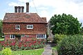
 Hole Cottage, near Cowden, Kent - geograph.org.uk - 40462.jpg 640 × 427; 142 KB
-
 Holes Bay - geograph.org.uk - 54680.jpg 640 × 427; 88 KB
-
 Holmbury hillfort - geograph.org.uk - 46561.jpg 640 × 427; 153 KB
-
 Hook Heath - geograph.org.uk - 45763.jpg 640 × 427; 61 KB
-
 Horam Railway Station.jpg 640 × 427; 137 KB
-
-
 Horsebridge Railway Station.jpg 640 × 427; 126 KB
-
 Horsell church - geograph.org.uk - 45606.jpg 427 × 640; 108 KB
-
 Houseboat on the Basingstoke Canal - geograph.org.uk - 45703.jpg 640 × 427; 95 KB
-
 Humberside fields - geograph.org.uk - 56497.jpg 640 × 436; 60 KB
-
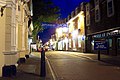 Hythe, Kent, at night - geograph.org.uk - 41737.jpg 640 × 427; 72 KB
-
 Idless Mill, near Truro - geograph.org.uk - 43576.jpg 640 × 427; 137 KB


_Mill,_Norfolk_-_geograph.org.uk_-_46615.jpg)


