Category:Images by Richard Harrison
Jump to navigation
Jump to search

Media in category "Images by Richard Harrison"
The following 101 files are in this category, out of 101 total.
-
 3 Levels of the shopping underworld - geograph.org.uk - 72149.jpg 480 × 640; 141 KB
-
 A blue phoenix in Cov - geograph.org.uk - 69043.jpg 640 × 480; 147 KB
-
 A dip into the Custard - geograph.org.uk - 103732.jpg 401 × 640; 105 KB
-
 A far from green meadow. - geograph.org.uk - 103715.jpg 427 × 640; 108 KB
-
 A lonely chimney - geograph.org.uk - 108569.jpg 640 × 433; 100 KB
-
 A red tree....that's it^ - geograph.org.uk - 103707.jpg 480 × 640; 153 KB
-
 A Tuesday evening at the Jampot - geograph.org.uk - 70179.jpg 640 × 480; 93 KB
-
 A view that could get me shot. - geograph.org.uk - 108597.jpg 640 × 350; 78 KB
-
 A view towards Bentley - geograph.org.uk - 108609.jpg 640 × 433; 106 KB
-
 Another view of Lloyd's Coppice - geograph.org.uk - 169300.jpg 426 × 640; 188 KB
-
 Ansley (wet) Fish Bar - geograph.org.uk - 73045.jpg 480 × 640; 119 KB
-
 Ansley Church Hall - geograph.org.uk - 72144.jpg 480 × 640; 103 KB
-
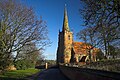
 St. Wilfrid's Church, Old Arley - geograph.org.uk - 69035.jpg 480 × 640; 104 KB
-
 The door to the rest of my life - geograph.org.uk - 69037.jpg 480 × 640; 161 KB
-
 Arley Sports Centre and Skate Park doode^ - geograph.org.uk - 70537.jpg 640 × 480; 164 KB
-
 Broomfield Farm, Bentley - geograph.org.uk - 103756.jpg 640 × 480; 113 KB
-
 Camp Hill houses - geograph.org.uk - 108461.jpg 426 × 640; 89 KB
-
 Corley church - geograph.org.uk - 103755.jpg 480 × 640; 179 KB
-
 Corley Cricket Club - geograph.org.uk - 106227.jpg 640 × 427; 141 KB
-
 Daw Mill...behind the wire - geograph.org.uk - 108571.jpg 640 × 437; 83 KB
-
 Ensor's Pool - geograph.org.uk - 117506.jpg 399 × 558; 99 KB
-
 Flaming shame^ - geograph.org.uk - 69036.jpg 640 × 480; 85 KB
-
 Furnace End...a chilly day then^ - geograph.org.uk - 108586.jpg 640 × 447; 123 KB
-

-
 Hurley post office - geograph.org.uk - 108602.jpg 640 × 410; 112 KB
-
 Jaguar's Heritage Centre, Coventry - geograph.org.uk - 71499.jpg 514 × 459; 76 KB
-
 Moor Street, more car parks - geograph.org.uk - 103737.jpg 640 × 331; 74 KB
-
 Mosaic detail in Cov Centre. - geograph.org.uk - 103708.jpg 640 × 429; 132 KB
-
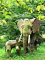 Newnham Paddox Sculpture Park - geograph.org.uk - 72141.jpg 480 × 640; 217 KB
-
 Priory Place on Diwali night - geograph.org.uk - 73038.jpg 480 × 640; 131 KB
-

-

-
 Round Towers, Stockingford - geograph.org.uk - 108580.jpg 640 × 530; 95 KB
-
 Sheffield's finest - geograph.org.uk - 69047.jpg 480 × 640; 102 KB
-
-
 St. Lawrence's Church, Church End - geograph.org.uk - 70524.jpg 479 × 640; 96 KB
-
 St. Leonard Church, Over Whitacre - geograph.org.uk - 108584.jpg 426 × 640; 117 KB
-
 St. Mary the Virgin, Astley - geograph.org.uk - 71509.jpg 480 × 640; 125 KB
-

-
 St. Thomas' Church, Keresley - geograph.org.uk - 103753.jpg 480 × 640; 146 KB
-

-
 The closed BBC Open Centre. - geograph.org.uk - 103712.jpg 480 × 640; 113 KB
-

-
 The Fir Tree, New Arley - geograph.org.uk - 70182.jpg 640 × 480; 66 KB
-

-
 The light of the Lord^ - geograph.org.uk - 70568.jpg 480 × 640; 130 KB
-
 The M6 at Corley - geograph.org.uk - 70560.jpg 640 × 480; 123 KB
-

-
 The Podger, Garforth - geograph.org.uk - 103720.jpg 640 × 427; 117 KB
-
 The Ricoh Arena, Coventry - geograph.org.uk - 70188.jpg 640 × 480; 78 KB
-
 The spaceship has landed - geograph.org.uk - 73042.jpg 480 × 640; 131 KB
-
 The Whittle Arch - geograph.org.uk - 69041.jpg 640 × 480; 76 KB
-
 What a doughnut^ - geograph.org.uk - 69038.jpg 640 × 480; 75 KB
-
 When the Big Sleep is over - geograph.org.uk - 71520.jpg 640 × 480; 102 KB
-

-
-
 Wyley Road, Radford - geograph.org.uk - 106220.jpg 427 × 640; 92 KB
-
 Ansley Common - geograph.org.uk - 108465.jpg 640 × 441; 104 KB
-
 Ansley Mill and Ford. - geograph.org.uk - 70532.jpg 640 × 480; 109 KB
-
 Ansley Park - geograph.org.uk - 108468.jpg 640 × 426; 53 KB
-
 Ansley Social Club - geograph.org.uk - 72142.jpg 640 × 480; 136 KB
-
 Bentley Park Wood Lake - geograph.org.uk - 103694.jpg 640 × 426; 126 KB
-
 Between charity and a lady. - geograph.org.uk - 103704.jpg 480 × 640; 155 KB
-
 Birchley Heath main-only street - geograph.org.uk - 103690.jpg 480 × 640; 129 KB
-
 Bird's Eye Brum - geograph.org.uk - 69039.jpg 640 × 480; 86 KB
-
 Blackdown the Hill - geograph.org.uk - 115026.jpg 569 × 412; 109 KB
-
 Bluebells - Moelfre - geograph.org.uk - 69048.jpg 480 × 640; 190 KB
-

-
 Brownshill Green Water Works - geograph.org.uk - 71504.jpg 640 × 480; 124 KB
-
 Burrow Hill Rocks - geograph.org.uk - 71506.jpg 640 × 480; 196 KB
-

-
 Coton Bridge, Marston. - geograph.org.uk - 108596.jpg 640 × 398; 115 KB
-

-
 Crow Hall - geograph.org.uk - 108601.jpg 640 × 429; 102 KB
-
 Custard Factory lights - geograph.org.uk - 103729.jpg 427 × 640; 104 KB
-
 Don't go into the woods today^ - geograph.org.uk - 70549.jpg 480 × 640; 104 KB
-
 Fillongley village and The Manor House - geograph.org.uk - 103758.jpg 480 × 640; 107 KB
-
 Glebe Farm and pheasants - geograph.org.uk - 74266.jpg 480 × 640; 160 KB
-
 Glebelands, land of fun. - geograph.org.uk - 103741.jpg 640 × 427; 111 KB
-
 Hey hey hay^ - geograph.org.uk - 113112.jpg 518 × 388; 224 KB
-
 Hill Top at dusk - geograph.org.uk - 71512.jpg 480 × 640; 85 KB
-
 Hoar Park - geograph.org.uk - 103751.jpg 480 × 640; 133 KB
-
 Home is where the Hart is - geograph.org.uk - 103692.jpg 640 × 480; 121 KB
-
 Judkins Quarry and Camp Hill's hill - geograph.org.uk - 108460.jpg 640 × 401; 99 KB
-
 Lloyd's Coppice in the Spring - geograph.org.uk - 169297.jpg 640 × 426; 174 KB
-
 Nuthurst Lane, Astley - geograph.org.uk - 74273.jpg 480 × 640; 123 KB
-
 Oakridge Golf Course, Ansley - geograph.org.uk - 72146.jpg 640 × 480; 151 KB
-
 Old bangers at Arley's best garage^ - geograph.org.uk - 70545.jpg 480 × 640; 149 KB
-
 Ox Hayes Farm, Church End - geograph.org.uk - 108565.jpg 640 × 257; 55 KB
-
 Plough Hill - geograph.org.uk - 103700.jpg 640 × 480; 127 KB
-
 Radio Masts at Ridge Lane - geograph.org.uk - 103689.jpg 426 × 640; 98 KB
-
 Reddington Rare Records Reflection - geograph.org.uk - 103735.jpg 427 × 640; 120 KB
-
 Shustoke village - geograph.org.uk - 108590.jpg 640 × 482; 130 KB
-
 Tamworth Road, Coventry - geograph.org.uk - 106223.jpg 640 × 427; 125 KB
-
 The beautifully named Devitt's Green - geograph.org.uk - 70552.jpg 480 × 640; 147 KB
-
 The Holly Bush, Hurley - geograph.org.uk - 108603.jpg 640 × 501; 118 KB
-
 The Jockey at Bentley - geograph.org.uk - 103691.jpg 480 × 640; 144 KB
-
 The road out of Foul End - geograph.org.uk - 108607.jpg 426 × 640; 91 KB
-
 Tippers Hill Lane, land of the rich - geograph.org.uk - 74270.jpg 480 × 640; 159 KB
-

-


_Fish_Bar_-_geograph.org.uk_-_73045.jpg)


