Category:Images by Alistair Bell
Jump to navigation
Jump to search

Media in category "Images by Alistair Bell"
The following 79 files are in this category, out of 79 total.
-

-
 Auchtergaven Church - geograph.org.uk - 1651940.jpg 640 × 454; 51 KB
-
 Bankfoot Tennis Court - geograph.org.uk - 624695.jpg 640 × 429; 72 KB
-
 Dunkeld Road, Bankfoot.jpg 640 × 427; 91 KB
-

-

-

-
-

-
 High Keillour Farm - geograph.org.uk - 1651864.jpg 640 × 428; 82 KB
-
 Little Glenshee Farm - geograph.org.uk - 1651880.jpg 640 × 425; 58 KB
-
 Little Glenshee Farm - geograph.org.uk - 1651895.jpg 640 × 425; 57 KB
-
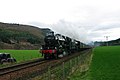
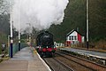 Locomotive 61994 at Dunkeld - geograph.org.uk - 1651997.jpg 640 × 425; 65 KB
-
 Locomotive 61994 at Dunkeld - geograph.org.uk - 1652008.jpg 640 × 425; 72 KB
-
 Locomotive 61994 at Dunkeld - geograph.org.uk - 1653640.jpg 640 × 425; 105 KB
-
 Murthly Castle Drive - geograph.org.uk - 638884.jpg 640 × 428; 81 KB
-
 Pictish Stone High Keillour - geograph.org.uk - 1651824.jpg 428 × 640; 62 KB
-
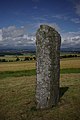 Pictish Stone High Keillour - geograph.org.uk - 1651841.jpg 428 × 640; 64 KB
-
 Pictish Stone High Keillour - geograph.org.uk - 1651857.jpg 428 × 640; 62 KB
-
 Quarry Site Little Glenshee - geograph.org.uk - 1651913.jpg 640 × 425; 66 KB
-
 Strathbraan - geograph.org.uk - 628041.jpg 640 × 427; 112 KB
-
 Towards Ardler from High Keillour - geograph.org.uk - 1651803.jpg 640 × 428; 73 KB
-
 View from High Keillour - geograph.org.uk - 1651791.jpg 640 × 428; 87 KB
-
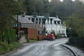
 Waterloovillage.jpg 640 × 426; 65 KB
-

-
 Airleywight House - geograph.org.uk - 639014.jpg 640 × 428; 50 KB
-
 Airleywight House - geograph.org.uk - 639023.jpg 640 × 428; 56 KB
-
 Auchtergaven Church - geograph.org.uk - 627166.jpg 640 × 427; 83 KB
-
 Auchtergaven Church - geograph.org.uk - 627179.jpg 640 × 427; 38 KB
-

-
 Auchtergaven Primary School - geograph.org.uk - 621423.jpg 640 × 427; 67 KB
-
 Auchtergaven Primary School - geograph.org.uk - 627184.jpg 640 × 427; 50 KB
-
 Bankfoot Bowling Club - geograph.org.uk - 624678.jpg 640 × 429; 57 KB
-
 Bankfoot Bowling Club - geograph.org.uk - 624684.jpg 640 × 429; 66 KB
-
 Bridge at Bardmony - geograph.org.uk - 627191.jpg 640 × 427; 47 KB
-
 Burn near Tulliebelton - geograph.org.uk - 624809.jpg 640 × 428; 111 KB
-
 Coral Corner - geograph.org.uk - 621410.jpg 640 × 427; 143 KB
-
 Coralgrove - geograph.org.uk - 621412.jpg 640 × 427; 102 KB
-
 Coronation Park - geograph.org.uk - 621418.jpg 640 × 427; 79 KB
-
 Craig Gibbon - geograph.org.uk - 638939.jpg 640 × 427; 73 KB
-
 East Nether Blellock - geograph.org.uk - 627139.jpg 640 × 427; 58 KB
-
 Farm House Near Little Tulliebelton - geograph.org.uk - 624728.jpg 640 × 427; 77 KB
-
 Farmhouse near to Little Tulliebelton - geograph.org.uk - 624814.jpg 640 × 427; 59 KB
-
 Field near Gellyburn - geograph.org.uk - 638874.jpg 640 × 428; 63 KB
-
 Ford Little Glenshee - geograph.org.uk - 627951.jpg 640 × 427; 62 KB
-
 Ford Little Glenshee - geograph.org.uk - 627955.jpg 640 × 427; 52 KB
-
 Ford Little Glenshee - geograph.org.uk - 627958.jpg 640 × 427; 78 KB
-
 Glen Garr - geograph.org.uk - 631124.jpg 640 × 427; 45 KB
-
 Glen Garr - geograph.org.uk - 631127.jpg 640 × 427; 62 KB
-
 Glen Garr - geograph.org.uk - 638914.jpg 640 × 427; 54 KB
-
 Glen Garr - geograph.org.uk - 638920.jpg 640 × 427; 56 KB
-
 Glen Garr - geograph.org.uk - 638929.jpg 427 × 640; 84 KB
-
 Glen Garr - geograph.org.uk - 638935.jpg 640 × 427; 59 KB
-
 Glen Garr - geograph.org.uk - 638940.jpg 640 × 427; 41 KB
-
 Glenn Garr - geograph.org.uk - 638907.jpg 640 × 427; 48 KB
-
 High Keillour Farm - geograph.org.uk - 621390.jpg 640 × 427; 86 KB
-
 Kirkstyle and Cemetery - geograph.org.uk - 624722.jpg 640 × 428; 42 KB
-
 Little Glenshee - geograph.org.uk - 627998.jpg 640 × 427; 53 KB
-
 Little Glenshee - geograph.org.uk - 628009.jpg 640 × 427; 70 KB
-
 Little Glenshee - geograph.org.uk - 628018.jpg 640 × 427; 70 KB
-
 Little Glenshee - geograph.org.uk - 628025.jpg 640 × 427; 48 KB
-
 Little Glenshee - geograph.org.uk - 628035.jpg 640 × 427; 75 KB
-
 Little Glenshee Farm - geograph.org.uk - 627975.jpg 640 × 427; 68 KB
-
 Little Glenshee Farm - geograph.org.uk - 627985.jpg 640 × 427; 56 KB
-
 Little Glenshee Junction - geograph.org.uk - 627981.jpg 640 × 427; 59 KB
-
 Little Glenshee towards Strathbraan - geograph.org.uk - 628038.jpg 640 × 427; 90 KB
-
 Millennium Walk - geograph.org.uk - 621415.jpg 640 × 426; 89 KB
-
 Millennium Walk - geograph.org.uk - 627149.jpg 640 × 427; 80 KB
-
 Millennium Walk - geograph.org.uk - 627151.jpg 640 × 427; 116 KB
-
 Millennium Walk - geograph.org.uk - 627157.jpg 640 × 427; 136 KB
-
 Near Balhomish - geograph.org.uk - 628054.jpg 640 × 427; 63 KB
-
 Nicoll Monument facing Obney Hill - geograph.org.uk - 619048.jpg 400 × 599; 36 KB
-
 Nicoll Monument near Tulliebelton - geograph.org.uk - 619103.jpg 640 × 427; 47 KB
-
 Obney Hill - geograph.org.uk - 621408.jpg 640 × 426; 47 KB
-
 Pea Harvesters near Bankfoot - geograph.org.uk - 627196.jpg 640 × 427; 47 KB
-
 Pea Harvesters near Bankfoot - geograph.org.uk - 627200.jpg 640 × 427; 54 KB
-
 Reflections at Queens View - geograph.org.uk - 627213.jpg 640 × 427; 90 KB
-
 Reflections at Queens view - geograph.org.uk - 627216.jpg 640 × 427; 122 KB
-
 Ruin Waterloo - geograph.org.uk - 621403.jpg 640 × 426; 108 KB


