Category:IS 20 Návěst pro cyklisty (Czech road sign)
Jump to navigation
Jump to search
Subcategories
This category has only the following subcategory.
Media in category "IS 20 Návěst pro cyklisty (Czech road sign)"
The following 83 files are in this category, out of 83 total.
-
 2012 Karwina, Łąki, Ulica Ke Statku, Znaki szlaku rowerowego.jpg 2,465 × 3,700; 6.98 MB
-
 A23 And A41 bikeways in Prague, Prague, Czech Republic.jpg 6,944 × 9,248; 27.35 MB
-
 Beranových, cyklistická návěst u Tupolevovy.jpg 2,448 × 3,264; 824 KB
-
 Bubeneč, Stromovka, plán cyklotras (01).jpg 3,662 × 4,896; 1.69 MB
-
 Bubeneč, Stromovka, plán cyklotras.jpg 3,264 × 2,448; 2.43 MB
-
 Bubeneč, Stromovka, schéma cyklotras.jpg 2,448 × 3,264; 2.17 MB
-
 Cesta od Leštiny do Lipnice nad Sázavou, značka cyklotrasy.jpg 2,816 × 2,112; 2.39 MB
-
 Chodovec, lávka na Roztyly (04).jpg 4,955 × 3,624; 2.95 MB
-
 Chodovec, lávka na Roztyly (05).jpg 5,010 × 3,702; 2.99 MB
-
 Chodovec, z lávky přes magistrálu.jpg 5,096 × 3,673; 3.38 MB
-
 Cyklisto, použij převozu.jpg 2,048 × 1,536; 680 KB
-
 Cyklostezky A26 a A267, Praha.jpg 3,472 × 4,624; 9.81 MB
-
 Cyklotabule u Hlávkova mostu.jpg 1,536 × 2,048; 217 KB
-
 Cyklotrasa A2, Praha 02.jpg 9,248 × 6,944; 42.37 MB
-
 Cyklotrasa Botič.jpg 890 × 1,056; 608 KB
-
 CZ-IS20 Návěst před křižovatkou pro cyklisty (2016).jpg 404 × 558; 26 KB
-

-
 CZ-IS20 Návěst před křižovatkou pro cyklisty.jpg 283 × 331; 15 KB
-
 Dalejské údolí, infotabule u cesty k Opatřilce.jpg 2,448 × 3,264; 2.03 MB
-
 Dalejské údolí, varovná tabule pro cyklisty.jpg 2,448 × 3,264; 1.35 MB
-
 Divoká Šárka, můstek východně od Želivky (03).jpg 3,264 × 2,448; 3.33 MB
-
 Divoká Šárka, tabule cyklotrasy (01).jpg 2,448 × 3,264; 1.77 MB
-
 Divoká Šárka, tabule cyklotrasy (02).jpg 2,448 × 3,264; 1.79 MB
-
 Divoká Šárka, tabule cyklotrasy.jpg 2,448 × 3,264; 2 MB
-
 Divoká Šárka, tabule pro cyklisty.jpg 3,264 × 2,448; 3.12 MB
-
 Greenway Labe, návěst.jpg 2,448 × 3,264; 1.05 MB
-
 Hloubětín, cyklostezka Rokytka, most přes Poděbradskou, severní předmostí.jpg 5,184 × 3,888; 4.92 MB
-
 Hládkov, cyklistická značka.jpg 2,448 × 3,264; 1.42 MB
-
 Holyně, K dobré vodě 16 a 18, přes brod, značka pro cyklisty.jpg 3,264 × 2,448; 2.37 MB
-
 Holyně, K dobré vodě, značka před brodem pod domy čo. 16 a 18.jpg 2,269 × 2,637; 683 KB
-
 Holyně, směrová tabule pro cyklisty u železniční zastávky.jpg 2,448 × 3,264; 2.01 MB
-
 Hostivařská přehrada.jpg 2,048 × 1,536; 677 KB
-
 IS20cr.jpg 341 × 400; 34 KB
-
 Kbely, pozor, chovejte se k sobě ohleduplně.jpg 2,448 × 3,264; 713 KB
-
 Kbely, Satalice, stezka podél trati.jpg 3,052 × 1,980; 930 KB
-
 Ke Spořilovu, návěst pro cyklisty.jpg 5,184 × 3,888; 5.99 MB
-
 Klecánky, Povltavská, cyklisto použij převozu.jpg 3,888 × 5,184; 7.07 MB
-
 Komořany, stezka pod Radotínským mostem, lávka.jpg 3,194 × 2,381; 1.22 MB
-
 Krčma 253.JPG 2,379 × 3,039; 2.89 MB
-
 Libeň cyklostezka podél Rokytky, most ulice Nad Kolčavkou.jpg 2,592 × 1,944; 3.29 MB
-
 Libeň, cyklostezka podél Rokytky pod Čuprovou ulicí (11).jpg 2,592 × 1,944; 3.36 MB
-
 Libeň, cyklostezka podél Rokytky pod Čuprovou ulicí (12).jpg 2,592 × 1,944; 3.19 MB
-
 Lochkov, Na dražkách, k ulici Za ovčínem.jpg 3,264 × 2,448; 2.28 MB
-
 Mutná 02.jpg 1,920 × 1,280; 337 KB
-
 Máslovice, Vltavská, dopravní značky (01).jpg 3,888 × 5,184; 7.65 MB
-
 Máslovice, Vltavská, dopravní značky (02).jpg 5,184 × 3,888; 3.86 MB
-
 Máslovice, Vltavská, dopravní značky.jpg 3,888 × 5,184; 7.82 MB
-
 Na ovčíně, hotel Nosál.jpg 3,264 × 2,448; 2.64 MB
-
 Nádraží Lysá nad Labem, cyklistické značky před podchodem.jpg 2,450 × 3,286; 1.48 MB
-
 Nádraží Lysá nad Labem, vstup do podchodu.jpg 3,648 × 2,736; 4.93 MB
-
 Obrok 7344.jpg 2,200 × 3,225; 3.45 MB
-
 Ostrožská Nová Ves, směrová tabule pro cyklisty.jpg 2,048 × 1,536; 534 KB
-
 Ostrožská Nová Ves, značky u přejezdu.jpg 2,048 × 1,536; 625 KB
-
 Pardubice, trať 238 u Paramo, vlak.jpg 5,184 × 3,888; 6.81 MB
-
 Pardubice, trať 238 u Paramo.jpg 5,184 × 3,888; 7.31 MB
-
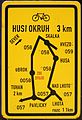
 Pavličky, značky cyklotras.jpg 2,448 × 3,264; 1.7 MB
-
 Pod Husou, přístřešek.jpg 3,264 × 2,448; 2.88 MB
-
 Podbabská - V Podbabě, semafor pro cyklisty (01).jpg 3,742 × 4,874; 3.04 MB
-
 Podbabská - V Podbabě, semafor pro cyklisty (02).jpg 3,729 × 4,896; 3 MB
-
 Podbabská - V Podbabě, semafor pro cyklisty, Podbabské skály.jpg 5,184 × 3,888; 5.7 MB
-
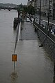 Povodně v Praze na Vltavě 2013 5039.JPG 2,592 × 3,888; 2.81 MB
-
 Povodně v Praze na Vltavě 2013 5054.JPG 3,888 × 2,592; 2.44 MB
-
 Průběžná 90, A231 a cykloservis (01).jpg 3,264 × 2,448; 1.99 MB
-
 Průběžná 90, A231 a cykloservis.jpg 2,448 × 3,264; 1.29 MB
-
 Průběžná 90, reklamy.jpg 3,264 × 2,448; 2.23 MB
-
 Pustověty, cyklistické značky.jpg 1,536 × 2,048; 348 KB
-
 Přívoz Klecánky-Roztoky 3.jpg 2,048 × 1,536; 384 KB
-
 Radotínská lávka, cyklistická návěst.jpg 2,448 × 3,264; 747 KB
-
 Rašínovo nábřeží, loď Bellevue (01).jpg 3,264 × 2,448; 1.96 MB
-
 Roztoky u Křivoklátu, rozcestník u mostu.jpg 2,448 × 3,264; 2.02 MB
-
 Sign of cycleway in Třebíč, Třebíč District.jpg 2,592 × 3,888; 579 KB
-
 Silver Mine Stribro Skansen (9).jpg 3,456 × 4,608; 3.7 MB
-
 Strážek 431.JPG 2,007 × 3,374; 2.28 MB
-
 Střezimíř, směrové tabule.jpg 2,448 × 3,264; 1.66 MB
-
 Střezimíř, U kovárny (01).jpg 3,264 × 2,448; 1.7 MB
-
 Text cycle sign, Cyklisté, dejte přednost chodcům.jpg 2,816 × 2,112; 1.16 MB
-
 Trojský most, cyklistická návěst od Holešovic.jpg 3,124 × 2,415; 562 KB
-
 Uvalno fingerposts.JPG 2,048 × 1,360; 679 KB
-
 V Podhoří, návěstní tabule pro cyklisty.jpg 2,448 × 3,264; 1.46 MB
-
 Vršovice, cyklistická návěst u mostů přes Botič u ulice U seřadiště.jpg 2,448 × 3,264; 1.25 MB
-
 Way to Blatenský vrch (Plattenberg) (1).jpg 4,000 × 3,000; 3.83 MB
-
 Zapora Lipno, cyklotrasy.jpg 3,648 × 2,736; 1.99 MB
-
 Západní začátek trasy.jpg 1,600 × 900; 328 KB


.jpg)


.jpg)
.jpg)


.jpg)
_(2016_-_verze_2015-07-31).jpg)


.jpg)
.jpg)
.jpg)


.jpg)
.jpg)


.jpg)
.jpg)


.jpg)
.jpg)


.jpg)


.jpg)


.jpg)


.jpg)


_(1).jpg)

