Category:Hydrographic maps of Javerlhac-et-la-Chapelle-Saint-Robert
Jump to navigation
Jump to search
Media in category "Hydrographic maps of Javerlhac-et-la-Chapelle-Saint-Robert"
The following 2 files are in this category, out of 2 total.
-
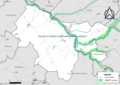
 24214-Javerlhac-et-la-Chapelle-Saint-Robert-Routes-Hydro.svg 1,056 × 744; 3.09 MB
-
 24214-Javerlhac-et-la-Chapelle-Saint-Robert-ZNIEFF1.png 3,519 × 2,480; 1.95 MB

