Category:Honddu Isaf
Jump to navigation
Jump to search
community in Powys  | |||||
| Upload media | |||||
| Pronunciation audio | |||||
|---|---|---|---|---|---|
| Instance of | |||||
| Location | Powys, Wales | ||||
| Population |
| ||||
| Area |
| ||||
 | |||||
Subcategories
This category has the following 3 subcategories, out of 3 total.
Media in category "Honddu Isaf"
The following 138 files are in this category, out of 138 total.
-

-
 Ancient boundary bank - geograph.org.uk - 1979927.jpg 640 × 480; 83 KB
-
 Approaching a road junction - geograph.org.uk - 3453021.jpg 1,024 × 680; 228 KB
-
 Approaching Pwllgloyw - geograph.org.uk - 5228611.jpg 640 × 480; 355 KB
-
 B4520 - geograph.org.uk - 5228617.jpg 640 × 480; 492 KB
-

-
 B4520 Capel Isaf (Lower Chapel) - geograph.org.uk - 5208293.jpg 640 × 480; 461 KB
-
 B4520 heads ESE towards Brecon - geograph.org.uk - 2981366.jpg 640 × 480; 73 KB
-
 B4520 heads south towards Brecon - geograph.org.uk - 3403484.jpg 640 × 432; 49 KB
-
 B4520 near Castle Madoc - geograph.org.uk - 5208285.jpg 640 × 427; 338 KB
-
 B4520 north of Brecon - geograph.org.uk - 3403455.jpg 640 × 480; 62 KB
-
 B4520 North of Brecon - geograph.org.uk - 5228653.jpg 640 × 427; 365 KB
-
 B4520 Southbound near Castle Madoc - geograph.org.uk - 5208287.jpg 640 × 427; 322 KB
-
 B4520 Tairderwen - geograph.org.uk - 5228651.jpg 640 × 427; 397 KB
-
 B4520 towards Lower Chapel - geograph.org.uk - 5208290.jpg 640 × 480; 434 KB
-
 B4520, Pwllgloyw - geograph.org.uk - 5208309.jpg 640 × 480; 334 KB
-
 B4520, Tanyrallt - geograph.org.uk - 5228607.jpg 640 × 427; 374 KB
-
 Beacons view - geograph.org.uk - 4798611.jpg 1,600 × 1,203; 1,019 KB
-
 Bend on the B4520 near Llandefaelog Fach - geograph.org.uk - 5228622.jpg 640 × 480; 358 KB
-
 Bends Ahead (B4520) - geograph.org.uk - 5228616.jpg 640 × 427; 397 KB
-
 Bethel chapel and manse - geograph.org.uk - 2932844.jpg 640 × 480; 72 KB
-
 Brecon Road - geograph.org.uk - 6616180.jpg 5,152 × 2,710; 6.06 MB
-
 Bridge at Llandefaelog - geograph.org.uk - 3453018.jpg 1,024 × 680; 306 KB
-
 Bridle path leading to Lower Chapel - geograph.org.uk - 1979877.jpg 640 × 480; 112 KB
-
 Bwlch-henllan Farm near Lower Chapel - geograph.org.uk - 923709.jpg 600 × 450; 126 KB
-
 Camden Cottage north of Brecon - geograph.org.uk - 2981311.jpg 640 × 476; 66 KB
-
 Canine alarm system - geograph.org.uk - 927056.jpg 640 × 480; 161 KB
-
 Castell Madoc - geograph.org.uk - 1245119.jpg 640 × 480; 83 KB
-
 Castle Madoc and lodge - geograph.org.uk - 927107.jpg 640 × 480; 115 KB
-
 Cefncoed Bach - geograph.org.uk - 3452903.jpg 1,024 × 680; 170 KB
-
 Church hall - geograph.org.uk - 4611583.jpg 4,320 × 3,240; 4.73 MB
-
 Church of St Michael (1) - geograph.org.uk - 4611558.jpg 4,320 × 3,240; 4.73 MB
-
 Church of St Michael (2) - geograph.org.uk - 4611562.jpg 4,320 × 3,240; 4.8 MB
-
 Church of St Michael (3) - geograph.org.uk - 4611565.jpg 3,240 × 4,320; 2.28 MB
-
 Coed Dyfodol Sarnau - geograph.org.uk - 3452896.jpg 1,024 × 680; 269 KB
-
 Country road near Garthbrengy - geograph.org.uk - 3451807.jpg 1,024 × 680; 167 KB
-
 Dan-y Wern, Pwllgloyw - geograph.org.uk - 3815437.jpg 640 × 480; 79 KB
-
 Drain-duon - geograph.org.uk - 3451829.jpg 1,024 × 680; 195 KB
-
 Edge of Brycheiniog Forest - geograph.org.uk - 4801109.jpg 1,600 × 901; 736 KB
-
 Entrance to Glan-dwr - geograph.org.uk - 3451845.jpg 1,024 × 680; 193 KB
-
 Entrance to Llethercynon - geograph.org.uk - 4800157.jpg 1,600 × 901; 757 KB
-
 Farm with a view, 1 - geograph.org.uk - 4799078.jpg 1,600 × 901; 707 KB
-
 Farm with a view, 2 - geograph.org.uk - 4799081.jpg 1,600 × 901; 542 KB
-
 Farmland access track, Garthbrengy - geograph.org.uk - 3451814.jpg 1,024 × 680; 219 KB
-
 Farmland around Garthbrengy - geograph.org.uk - 4799053.jpg 1,600 × 902; 1.13 MB
-
 Farmland near Garthbrengy - geograph.org.uk - 3450952.jpg 1,024 × 680; 150 KB
-
 Farmland near Lower Porthgwyn - geograph.org.uk - 3451819.jpg 1,024 × 680; 224 KB
-
 Fields near Glan-Dwr - geograph.org.uk - 3815429.jpg 640 × 480; 45 KB
-
 Fields near to Lower Pontgwilym - geograph.org.uk - 3913450.jpg 1,500 × 799; 802 KB
-
 Fields Near Troedyrharn - geograph.org.uk - 3161902.jpg 2,288 × 1,712; 840 KB
-

-

-
 Great view of the Black Mountains - geograph.org.uk - 4800141.jpg 1,600 × 901; 626 KB
-
 Hillside above Nant Fawr - geograph.org.uk - 927087.jpg 640 × 480; 103 KB
-
 Houses at Lower Chapel - geograph.org.uk - 5208304.jpg 640 × 480; 432 KB
-

-
 Lane heading past Llethercynon - geograph.org.uk - 646309.jpg 640 × 425; 64 KB
-
 Lane to two farms north of Brecon - geograph.org.uk - 2981344.jpg 640 × 480; 90 KB
-

-
 Lower Chapel (1) - geograph.org.uk - 4611572.jpg 4,320 × 3,240; 4.88 MB
-
 Lower Chapel (2) - geograph.org.uk - 4611576.jpg 4,320 × 3,240; 4.66 MB
-
 Lower Chapel (Capel Isaf) - geograph.org.uk - 5208299.jpg 640 × 480; 396 KB
-
 Lower Chapel, Church Hall - geograph.org.uk - 4993256.jpg 640 × 480; 457 KB
-

-
 Manse at Bethel Chapel - geograph.org.uk - 5208307.jpg 640 × 480; 362 KB
-
 Minor road to Llanddew - geograph.org.uk - 2981382.jpg 640 × 480; 76 KB
-
 Nant Fawr - geograph.org.uk - 5412619.jpg 640 × 480; 133 KB
-
 Nant y Gof - geograph.org.uk - 4611613.jpg 4,320 × 3,240; 4.79 MB
-
 No through road near Garthbrengy - geograph.org.uk - 3451856.jpg 1,024 × 680; 187 KB
-
 Old building at Lower Chapel - geograph.org.uk - 2932826.jpg 640 × 480; 68 KB
-

-

-
 On the bridleway to Pen-y-lan, 1 - geograph.org.uk - 4800149.jpg 1,600 × 901; 695 KB
-
 On the bridleway to Pen-y-lan, 2 - geograph.org.uk - 4800153.jpg 1,600 × 901; 710 KB
-
 On the bridleway to Pen-y-lan, 3 - geograph.org.uk - 4800167.jpg 1,600 × 901; 738 KB
-
 On the bridleway to Pen-y-lan, 4 - geograph.org.uk - 4801102.jpg 1,600 × 901; 655 KB
-
 On the bridleway to Pen-y-lan, 5 - geograph.org.uk - 4801103.jpg 1,600 × 901; 677 KB
-
 Ordnance Survey Cut Mark - geograph.org.uk - 4500726.jpg 480 × 640; 130 KB
-
 Ordnance Survey Cut Mark - geograph.org.uk - 4955031.jpg 634 × 640; 143 KB
-
 Ordnance Survey Cut Mark - geograph.org.uk - 5259955.jpg 424 × 640; 83 KB
-
 Ordnance Survey Cut Mark - geograph.org.uk - 5259956.jpg 640 × 436; 110 KB
-
 Ordnance Survey Rivet - geograph.org.uk - 5259953.jpg 429 × 640; 104 KB
-
 Outside the gate - geograph.org.uk - 927115.jpg 640 × 480; 138 KB
-
 Pasture land near Lower Chapel - geograph.org.uk - 923699.jpg 600 × 450; 147 KB
-
 Pencaemelyn - geograph.org.uk - 4799084.jpg 1,600 × 901; 721 KB
-
 Pencaemelyn Farm - geograph.org.uk - 3451804.jpg 1,024 × 680; 186 KB
-
 Pont-Gwilym Uchaf - geograph.org.uk - 5703320.jpg 1,024 × 680; 304 KB
-
 Pont-Gwilym Uchaf - geograph.org.uk - 5704352.jpg 1,600 × 900; 583 KB
-
 Pool opposite Pant-y-cored - geograph.org.uk - 3451838.jpg 1,024 × 680; 192 KB
-
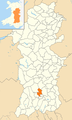 Powys Wales communities - Honddu Isaf locator.png 780 × 1,300; 430 KB
-
 Pwllgloyw Arms - geograph.org.uk - 3815436.jpg 640 × 480; 59 KB
-
 Pwllgloyw, Bethel Chapel.jpg 4,032 × 3,024; 3.06 MB
-
 Pwllgloyw.jpg 3,264 × 2,448; 2.8 MB
-
 Quarry on south face of Ysgwydd Hwch - geograph.org.uk - 1931763.jpg 640 × 480; 118 KB
-
 Rampart, Twyn-y-gaer - geograph.org.uk - 5618644.jpg 640 × 480; 56 KB
-
 Reseeded grassland - geograph.org.uk - 926950.jpg 640 × 480; 81 KB
-
 Road at Sarnau - geograph.org.uk - 3453019.jpg 1,024 × 680; 233 KB
-
 Road north near Twyn-y-gaer - geograph.org.uk - 926960.jpg 640 × 480; 73 KB
-
 Road to Garthbrengy - geograph.org.uk - 3453016.jpg 1,024 × 680; 179 KB
-

-

-
 Roadside seat - geograph.org.uk - 4611611.jpg 4,320 × 3,240; 4.87 MB
-

-
 Rowan seedling in fence post - geograph.org.uk - 1873187.jpg 640 × 480; 45 KB
-
 Seland Newydd Pwllgloyw - geograph.org.uk - 646468.jpg 640 × 425; 69 KB
-
 Sheep at Sarnau - geograph.org.uk - 3453020.jpg 1,024 × 680; 190 KB
-
 Sheep in pasture - geograph.org.uk - 4799087.jpg 1,600 × 586; 391 KB
-
 Small substation - geograph.org.uk - 4611615.jpg 4,320 × 3,240; 4.85 MB
-
 Some Fine Old Trees - geograph.org.uk - 4953669.jpg 1,752 × 1,159; 1,003 KB
-
 Some Riverside Yews - geograph.org.uk - 4953682.jpg 1,412 × 941; 1.04 MB
-
 South-east from the access land - geograph.org.uk - 816252.jpg 640 × 427; 75 KB
-
 Southbound B4520, North of Brecon - geograph.org.uk - 5228650.jpg 640 × 427; 400 KB
-
 T-junction east of Cradoc - geograph.org.uk - 2981145.jpg 640 × 480; 66 KB
-
 Tairderwen north of Brecon - geograph.org.uk - 2981202.jpg 640 × 480; 54 KB
-
 The B4520 descends towards Brecon - geograph.org.uk - 2981403.jpg 640 × 480; 89 KB
-
 The B4520 heading to Lower Chapel - geograph.org.uk - 646471.jpg 640 × 425; 63 KB
-
 The B4520 NW of Tairderwen - geograph.org.uk - 2981211.jpg 630 × 640; 99 KB
-
 Track across the fields at Castle Madoc - geograph.org.uk - 927952.jpg 600 × 450; 168 KB
-
 Twyn y Gaer Iron Age Hillfort - geograph.org.uk - 713151.jpg 480 × 640; 55 KB
-
 Twyn-y-gaer Iron Age Hill Fort - geograph.org.uk - 3451017.jpg 1,024 × 680; 150 KB
-
 Twyn-y-gaer Iron Age Hill Fort - geograph.org.uk - 3451026.jpg 1,024 × 680; 192 KB
-
 Twyn-y-Gaer Iron Age Hill Fort - geograph.org.uk - 646292.jpg 640 × 425; 51 KB
-
 Twyn-y-gaer trig point - geograph.org.uk - 5618629.jpg 640 × 480; 67 KB
-
 Upland farmland near Cwm-Gwilym - geograph.org.uk - 3450994.jpg 1,024 × 680; 169 KB
-
 View across towards Upper Chapel - geograph.org.uk - 713217.jpg 640 × 480; 49 KB
-
 View south of Rhos Farm - geograph.org.uk - 923010.jpg 640 × 480; 98 KB
-
 View to Danreglwys - geograph.org.uk - 3451852.jpg 1,024 × 680; 234 KB
-
 View to Pen-y-crug fort - geograph.org.uk - 3453022.jpg 1,024 × 680; 249 KB
-
 View to the Black Mountains - geograph.org.uk - 5705637.jpg 1,024 × 680; 247 KB
-
 View to the Brecon Beacons - geograph.org.uk - 3450942.jpg 1,024 × 680; 201 KB
-
 View to the Brecon Beacons - geograph.org.uk - 3451802.jpg 1,024 × 680; 176 KB
-
 View to the Brecon Beacons - geograph.org.uk - 3453017.jpg 1,024 × 680; 170 KB
-
 View towards mountains - geograph.org.uk - 3815440.jpg 640 × 480; 61 KB
-
 View towards the Black Mountains - geograph.org.uk - 5703317.jpg 1,024 × 680; 252 KB
-
 Wales Powys Community Honddu Isaf map.svg 512 × 723; 1.15 MB
-
 Wall post box - geograph.org.uk - 4611605.jpg 3,240 × 4,320; 3.06 MB
-
 Young oak tree - geograph.org.uk - 926987.jpg 640 × 480; 87 KB
-
 Ysgwydd Hwch - geograph.org.uk - 4801108.jpg 1,600 × 902; 645 KB


_-_geograph.org.uk_-_5208293.jpg)


_-_geograph.org.uk_-_5228616.jpg)


_-_geograph.org.uk_-_4611558.jpg)
_-_geograph.org.uk_-_4611562.jpg)
_-_geograph.org.uk_-_4611565.jpg)


_-_geograph.org.uk_-_4611572.jpg)
_-_geograph.org.uk_-_4611576.jpg)
_-_geograph.org.uk_-_5208299.jpg)


