Category:Hohes Haus (Märstetten)
Jump to navigation
Jump to search
| Object location | | View all coordinates using: OpenStreetMap |
|---|
 | |||||
| Upload media | |||||
| Instance of | |||||
|---|---|---|---|---|---|
| Part of | |||||
| Location |
| ||||
| Street address |
| ||||
| Heritage designation |
| ||||
 | |||||
|
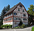
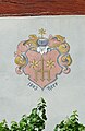
This is a category about a cultural property of national significance in Switzerland with KGS number 10222
|
Media in category "Hohes Haus (Märstetten)"
The following 16 files are in this category, out of 16 total.
-
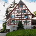 Hohes Haus in Märstetten TG.jpg 3,840 × 3,840; 9.55 MB
-
 Hohes Haus in Märstetten.jpg 3,840 × 3,456; 7.43 MB
-
 MaerstettenDorf.jpg 1,383 × 1,080; 1.53 MB
-
 MaerstettenHohesHaus.jpg 1,823 × 964; 1.41 MB
-
 MaerstettenHohesHaus1.jpg 1,080 × 993; 1,011 KB
-
 MaerstettenHohesHaus2.jpg 1,080 × 1,519; 1.1 MB
-
 MaerstettenHohesHaus3.jpg 1,080 × 1,610; 1.26 MB
-
 MaerstettenHohesHausKirche.jpg 1,854 × 1,062; 1.82 MB
-
 MaerstettenHohesHausPforte.jpg 1,080 × 1,779; 1.68 MB
-
 MaerstettenHohesHausRemise.jpg 1,565 × 1,080; 1.18 MB
-
 MaerstettenHohesHausSued.jpg 1,080 × 993; 985 KB
-
 MaerstettenHohesHausWappen.jpg 1,010 × 1,665; 1.38 MB
-
 MaerstettenHohesHausWappenFreiherren.jpg 968 × 1,450; 1.11 MB
-
 MaerstettenHohesHausWappenHeer.jpg 995 × 1,525; 1.23 MB
-
 MaerstettenHohesHausWest.jpg 1,138 × 1,048; 1.34 MB
-
 MaerstettenKigehausHohesHaus.jpg 1,810 × 1,025; 1.17 MB


