Category:Hill forts in Powys
Jump to navigation
Jump to search
Wikimedia category | |||||
| Upload media | |||||
| Instance of | |||||
|---|---|---|---|---|---|
| Category combines topics | |||||
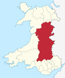
| Powys | |||||
principal area and preserved county in mid-Wales, United Kingdom | |||||
| Instance of | |||||
| Location | Wales | ||||
| Population |
| ||||
| Area |
| ||||
| Different from | |||||
| official website | |||||
 | |||||
Subcategories
This category has the following 11 subcategories, out of 11 total.
B
- Bausley Hill Camp (20 F)
- Beacon Ring (23 F)
C
- Castell Dinas (8 F)
- Craig Rhiwarth, Powys (8 F)
- Crug Hywel (11 F)
F
- Ffawyddog Gaer (2 F)
- Ffridd Faldwyn (12 F)
L
- Llwyn Bryn-Dinas (6 F)
P
- Pen-y-crug (32 F)
T
- Tinboeth Castle (2 F)
Media in category "Hill forts in Powys"
The following 32 files are in this category, out of 32 total.
-
Barley land at Garthbrengy 3 - geograph.org.uk - 926984.jpg 640 × 480; 106 KB
-
Bryn Mawr from The Montgomery Canal - geograph.org.uk - 571453.jpg 640 × 480; 115 KB
-
Burfa Camp hillfort - geograph.org.uk - 901434.jpg 640 × 480; 92 KB
-
Fort above Glascwm - geograph.org.uk - 391288.jpg 640 × 480; 75 KB
-
Hill Fort - geograph.org.uk - 1363502.jpg 640 × 480; 138 KB
-
Hill Fort - geograph.org.uk - 1366581.jpg 640 × 480; 152 KB
-
Hillfort, Wern - geograph.org.uk - 429030.jpg 640 × 480; 91 KB
-
Moel-Ddolwen from the west - geograph.org.uk - 1428668.jpg 640 × 480; 93 KB
-
Mynydd Illtud Powys Twyn y Gaer HenSne 02 trig point.JPG 2,160 × 1,620; 1.48 MB
-
Mynydd Illtud Powys Twyn y Gaer HenSne 03.JPG 2,160 × 1,620; 1.17 MB
-
Pentre Camp Hill Fort, Llangyniew (geograph 2963273).jpg 2,560 × 1,920; 1.11 MB
-
Pillow mound at Twyn y Gaer - geograph.org.uk - 375686.jpg 640 × 480; 157 KB
-
Roundton Hill from the northeast - geograph.org.uk - 1123674.jpg 640 × 480; 110 KB
-
Roundton Hill to Corndon - geograph.org.uk - 1123613.jpg 640 × 480; 66 KB
-
Slwch Tump - geograph.org.uk - 344523.jpg 640 × 480; 180 KB
-
Table Mountain - geograph.org.uk - 609489.jpg 640 × 480; 140 KB
-
The Ramparts - geograph.org.uk - 165992.jpg 640 × 480; 136 KB
-
Todleth Hill from Roundton hillfort - geograph.org.uk - 1123628.jpg 640 × 480; 68 KB
-
Toposcope on Roundton Hill - geograph.org.uk - 1123645.jpg 640 × 480; 68 KB
-
Twyn y Gaer iron age hill fort at Mynydd Illtud, east side.jpg 4,000 × 3,000; 2.42 MB
-
Twyn y Gaer Iron Age Hill Fort, situated atop the Gaer mountain, S. Wales..jpg 4,000 × 3,205; 9.8 MB
-
Twyn y Gaer Iron Age Hillfort - geograph.org.uk - 713151.jpg 480 × 640; 55 KB
-
View northwest towards Crug Hywel - geograph.org.uk - 1208778.jpg 640 × 480; 60 KB
-
View south from Gaer Fach - geograph.org.uk - 927170.jpg 640 × 480; 96 KB
-
Double Hill - geograph.org.uk - 654877.jpg 640 × 398; 73 KB
-
Gaer Hill Fort - geograph.org.uk - 649458.jpg 640 × 480; 54 KB
-
Hill fort ramparts at Gaer Fawr - geograph.org.uk - 568616.jpg 640 × 480; 101 KB
-
Panorama at Cefn y Coed - geograph.org.uk - 552202.jpg 640 × 349; 56 KB
-
Ramparts at Gaer Fawr hill fort - geograph.org.uk - 568617.jpg 640 × 480; 91 KB


