Category:Highway 19 (Taiwan)
Jump to navigation
Jump to search
road in Taiwan | |||||
| Upload media | |||||
| Instance of | |||||
|---|---|---|---|---|---|
| Location | |||||
| Transport network | |||||
| Maintained by | |||||
| Has part(s) |
| ||||
| Length |
| ||||
| |||||
English: Provincial Highway 19 (Taiwan).
日本語: 台19省道。
中文(臺灣):臺19省道。
中文(中国大陆):台19省道。
Subcategories
This category has only the following subcategory.
B
Media in category "Highway 19 (Taiwan)"
The following 14 files are in this category, out of 14 total.
-
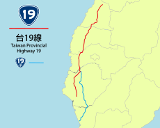
TW PHW19 RouteMap.svg 500 × 400; 459 KB
-
TW PHW19.png 480 × 480; 47 KB
-
TW PHW19a.png 480 × 480; 49 KB
-
Level crossing of the Magongcuo Line with Highway 19.jpg 6,016 × 4,016; 10.92 MB
-
Level crossing of the Magongcuo Line with Highway 20.jpg 6,016 × 4,016; 11.21 MB
-
Starting point of Taiwan Provincial Highway 19.jpg 1,600 × 1,123; 585 KB
-
Taiwan 19th path sign.jpg 3,264 × 2,448; 564 KB
-
TW PHW19.svg 875 × 875; 13 KB
-
TW PHW19a.svg 875 × 875; 16 KB
-
Visitors Walking at Jieshou West Road to Gangshan Air Force Base 20170812.jpg 4,928 × 3,264; 1.7 MB
-
佳里市區北郊.JPG 3,072 × 1,728; 1.31 MB
-
台19線永康,往終點.jpg 1,477 × 1,108; 141 KB
-
彰化縣竹塘鄉 台19線 Provincial Highway No.19(Zhutang,Changhua) - panoramio.jpg 3,264 × 2,448; 1.09 MB
-
忙碌的早餐店 (51346992911).jpg 4,586 × 3,057; 7.85 MB


