
Category:Gweedore
Brezhoneg: Gaoth Dobhair ( saozneg: Gweedore) a zo ur gêr vihan eus kornaoueg Iwerzhon, e kontelezh Donegal, war an aod.
Cymraeg: Ardal yn Swydd Donegal yng ngogledd orllewin Iwerddon yw Gaoth Dobhair (Saesneg: Gweedore). Mae hi'n 30 milltir i'r gorllewin o Letterkenny/Leitir Ceanainn, ar lan y môr. Mae 4,356 o bobl yn byw yn ardal Gaoth Dobhair (2006).
Dansk: Gweedore ( Irsk: Gaoth Dobhair) er en irsk by i County Donegal i provinsen Ulster, i den nordlige del af Republikken Irland med en befolkning (inkl. opland) på 4.000 indb i 2006.
Deutsch: Gweedore ( irisch: Gaoth Dobhair) ist eine Ortschaft und ein Verwaltungsdistrikt im irischen County Donegal.
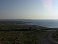
English: Gweedore (official name: Gaoth Dobhair) is an Irish-speaking district located on the Atlantic coast of County Donegal, Ireland. Gweedore is also the home of the northwest regional studios of the Irish language radio service RTÉ Raidió na Gaeltachta, and it is officially the largest Irish-speaking parish in Ireland with a population of around 4,065. It is made up of five main townlands, Bunbeg, Derrybeg, Dunlewey, Crolly and Bloody Foreland, and it sits in the shade of Donegal's tallest peak Mount Errigal.
Esperanto: Gaoth Dobhair (irlandlingve kaj oficiale Gaoth Dobhair, angle Gweedore) estas urbeto ĉe la okcidenta marbordo de County Donegal, Irlando. La totala nombro da loĝantoj estas 5,000(2006).
Español: Gweedore (Gaoth Dobhair, en irlandés) es la ciudad más pequeña del Condado de Donegal, en la parte más septentrional de la República de Irlanda, y se localiza a 65 km al norte de la ciudad de Donegal y a 50 km al oeste de Derry, en Irlanda del Norte.
Euskara: Gaoth Dobhair edo Gweedore Donegalgo konderrian dagoen udalerri txikia da, 2002an ia 1.400 biztanle baino ez izanik. Inguru guztia kontuan hartuta, 5.000 pertsona bizi dira han.
Français : Gaoth Dobhair (le nom est régulièrement anglicisé en Gweedore, même si cette dénomination n’a rien d’officiel) est une petite ville située sur la côte nord de l' Atlantique, dans le Comté de Donegal, en Irlande.
Gaeilge: Gaoth Dobhair (Gweedore i m Béarla): ceantar Gaeltachta i gcontae Dhún na nGall, Éire. Anseo, tá seirbhís réigiúnach de chuid Raidió na Gaeltachta lonnaithe, agus is ea Gaoth Dobhair an paróiste Gaeltachta is mó in Éirinn le daonra do 4,065. Is iad na príomhbhailte fearainn ná Croithlí, Dún Lúiche, An Bun Beag, Doirí Beaga, Cnoc Fola agus suíonn siad faoi scáth an Earagail, an cnoc is airde i gCo. Dhún na nGall.
Italiano: Gweedore ( Gaelico irlandese: Gaoth Dobhair) è una cittadina situata nel nord dell'Irlanda vicino alla costa atlantica, della zona Gaeltacht del Donegal, nel territorio della Repubblica d'Irlanda. Il centro è conosciuto per essere il luogo di nascita di importanti artisti come i Clannad, Enya (Eithne Ní Bhraonáin) e Altan (Mairéad Ní Mhaonaigh). Gweedore è anche la sede nordoccidentale della trasmittente radio in lingua gaelica Raidió na Gaeltachta.
日本語: グウィドー(英語:)は アイルランドはドニゴール州北部の大西洋岸に位置する町である。ゲール語の話される地域(ゲルタハト)として知られる。アイルランド語によるラジオ放送「ラヂオ・ナ・ゲルタハタ」(Raidió na Gaeltachta)のスタジオがある。
Nederlands: Gweedore ( Iers: Gaoth Dobhair) is een plaats in het Ierse graafschap County Donegal. De plaats telt 4.065 inwoners.
Norsk bokmål: Gaoth Dobhair (engelsk Gweedore) er en landsby vest for Donegal i Republikken Irland. Ettersom byen ligger i den gaelisktalende del av Irland, kommer det hver sommer studenter til byen for å lære språket i et miljø hvor det praktiseres daglig.
Occitan : Gaoth Dobhair (Gweedore en anglés) es un villatge d’Irlanda, en lo Comtat de Donegal (Ulster), sus la riba del Ocean Atlantic. L'irlandés qu’ei la primièra lenga de la localitat.
Português: Gaoth Dobhair (Gweedore em inglês) é um povoado de 4000 habitantes da República da Irlanda situado no condado de Donegal.
Svenska: Gaoth Dobhair ( engelska: Gweedore) är en by på kusten av Atlantiska oceanen i grevskapet Donegal på Irland. Orten ligger i ett gaeltachtområde vilket betyder att iriska är talat av majoriteten av invånarna.
parish in County Donegal, Ireland  Radharc ar Ghaoth Dobhair ón spéir. | |||||
| Upload media | |||||
| Instance of | |||||
|---|---|---|---|---|---|
| Location | County Donegal, Ulster, Ireland | ||||
| Population |
| ||||
| Elevation above sea level |
| ||||
| official website | |||||
 | |||||
Subcategories
This category has the following 15 subcategories, out of 15 total.
A
B
- Gearóidín Bhreathnach (1 F)
- Bloody Foreland (11 F)
- Moya Brennan (20 F)
C
D
F
- Fawnboy Bog/Lough Nacung (2 F)
M
- Maria McCool (1 F)
N
- Mairéad Ní Mhaonaigh (4 F)
Media in category "Gweedore"
The following 52 files are in this category, out of 52 total.
-
 Aislanngd.jpg 1,536 × 872; 170 KB
-
 Amharclann2.jpg 3,993 × 1,735; 1.9 MB
-
 Amharclann4.jpg 4,032 × 3,024; 3.71 MB
-
 Amharclanngd.jpg 2,048 × 1,536; 481 KB
-
 Artificial watercourse - geograph.org.uk - 1030308.jpg 640 × 480; 43 KB
-
 At Gweedore, Co. Donegal (23350774204).jpg 2,000 × 1,517; 1.62 MB
-
 At Gweedore, Co. Donegal (23352182413).jpg 2,000 × 1,513; 1.82 MB
-
 Bungalow near Gweedore - geograph.org.uk - 1030317.jpg 640 × 480; 75 KB
-
 Bád Eddie, Gaoth Dobhair (2010).jpg 720 × 481; 82 KB
-
 Clgghaothdobhair.jpg 2,045 × 420; 132 KB
-
 Cnocfola335.jpg 500 × 375; 50 KB
-
 Coshclady Townland - geograph.org.uk - 2424887.jpg 640 × 480; 55 KB
-
 Curransport.JPG 3,072 × 2,304; 1.79 MB
-
 Doiribeaga.jpg 800 × 600; 101 KB
-
 Doiribeaga.JPG 2,048 × 1,536; 1.62 MB
-

-
 Gaothdobhairamharclann.JPG 3,072 × 2,304; 1.78 MB
-
 Gaothdobhairpier.JPG 3,072 × 1,728; 2.34 MB
-
 Gaothdobhairpier2.JPG 3,072 × 1,728; 2.32 MB
-
 Gola-TwinCaveArea.jpg 2,560 × 1,920; 1.07 MB
-
 Golabeach.jpg 500 × 332; 117 KB
-
 Golaisland.jpg 500 × 330; 107 KB
-

-
 Gweedore - Old building near Meenaclady - geograph.org.uk - 1338020.jpg 640 × 427; 103 KB
-

-
 Gweedore area - Peat cutting off R257 - geograph.org.uk - 1332770.jpg 640 × 426; 151 KB
-

-

-
 Gweedore Fire Station - geograph.org.uk - 1030318.jpg 640 × 480; 63 KB
-
 Gweedore graveyard.jpg 1,632 × 1,224; 372 KB
-
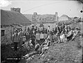 Gweedore Natives, Gweedore, Co. Donegal (23611131279).jpg 2,000 × 1,520; 1.72 MB
-
 Gweedore.jpg 604 × 452; 25 KB
-
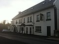
 Halfway House at Gweedore in Co. Donegal (11113786414).jpg 2,000 × 1,541; 1.87 MB
-
 Hiudaibeag.jpg 2,592 × 1,936; 1.27 MB
-
 Inis oirthir4.jpg 6,016 × 4,000; 7.06 MB
-
 Irish Turf Smoke Ltd - geograph.org.uk - 1030312.jpg 640 × 480; 66 KB
-
 Lafheilepadraiggaothdobhair.jpg 912 × 594; 107 KB
-
 Machairegathlan.jpg 862 × 586; 53 KB
-
 Magheragallonpier2.JPG 3,072 × 1,728; 2.35 MB
-

-
-

-
 New housing development - geograph.org.uk - 1030309.jpg 640 × 480; 67 KB
-
 Noel and Pádraig Duggan.jpg 400 × 331; 50 KB
-
 One off housing in Donegal.jpg 604 × 452; 48 KB
-
 Pobalscoilmor.jpg 795 × 418; 48 KB
-
 Preparing to land at Donegal - geograph.org.uk - 1159605.jpg 639 × 426; 282 KB
-
 R258 Road at Coshclady - geograph.org.uk - 2424891.jpg 640 × 480; 44 KB
-
 Road at Coshclady - geograph.org.uk - 2424897.jpg 640 × 480; 68 KB
-

-
 Sean Teach Phobail na Doirí Beaga.jpg 1,600 × 1,200; 264 KB
-
 Site with planning permission - geograph.org.uk - 1030310.jpg 640 × 480; 78 KB


.jpg)
.jpg)

.jpg)


.jpg)

.jpg)


