Category:Grand Est photographs taken on 2016-07-06
Jump to navigation
Jump to search
Administrative regions and territorial collectivity of Metropolitan France (‡ since start of 2016):
Grand Est‡ · Île-de-France
Grand Est‡ · Île-de-France
| Grand Est photographs of the previous week | · | Grand Est photographs of the previous day | ← | 2016-07-06 | → | Grand Est photographs of the next day | · | Grand Est photographs of the next week |
| 29 | · | 30 | · | 1 | · | 2 | · | 3 | · | 4 | · | 5 | · | 6 | · | 7 | · | 8 | · | 9 | · | 10 | · | 11 | · | 12 | · | 13 |

Grand Est photographs taken on July 6, 2016.
Files or subcategories can be added here using a direct categorization tag. Image files can be categorized here also automatically using {{Taken on}} template.
Media in category "Grand Est photographs taken on 2016-07-06"
The following 151 files are in this category, out of 151 total.
-
 Bayon (M-et-M) wind wheel (01).jpg 3,648 × 2,736; 4.21 MB
-
 Bayon (M-et-M) wind wheel (02).jpg 2,736 × 3,648; 4.22 MB
-
 Borville (M-et-M) city limit sign.jpg 3,648 × 2,736; 4.27 MB
-
 Borville (M-et-M) dessus de porte maison A.jpg 3,648 × 2,736; 4.1 MB
-
 Borville (M-et-M) dessus de porte maison B.jpg 3,648 × 2,736; 3.94 MB
-
 Borville (M-et-M) dessus de porte maison C.jpg 2,736 × 3,648; 3.57 MB
-
 Borville (M-et-M) lavoir.jpg 3,648 × 2,736; 3.73 MB
-
 Borville (M-et-M) mairie.jpg 3,648 × 2,736; 3.73 MB
-
 Borville (M-et-M) église (01).jpg 2,736 × 3,648; 3.27 MB
-
 Borville (M-et-M) église (02).jpg 2,736 × 3,648; 2.37 MB
-
 Brémoncourt (M-et-M) city limit sign.jpg 3,648 × 2,736; 4.29 MB
-
 Brémoncourt (M-et-M) croix de chemin.jpg 2,736 × 3,648; 4.15 MB
-
 Brémoncourt (M-et-M) mairie - école.jpg 3,648 × 2,736; 3.56 MB
-
 Brémoncourt (M-et-M) salle polyvalente.jpg 3,648 × 2,736; 3.59 MB
-
 Brémoncourt (M-et-M) église (01).jpg 3,648 × 2,736; 3.6 MB
-
 Brémoncourt (M-et-M) église (02).jpg 2,736 × 3,648; 3.45 MB
-
 Brémoncourt (M-et-M) église (03).jpg 3,648 × 2,736; 3.71 MB
-
 Charmois (M-et-M) vue de Charmois.jpg 3,648 × 2,736; 4.21 MB
-
 Domptail-en-l'Air (M-et-M) city limit sign.jpg 3,648 × 2,736; 3.52 MB
-
 Domptail-en-l'Air (M-et-M) mairie.jpg 3,648 × 2,736; 3.35 MB
-
 Domptail-en-l'Air (M-et-M) monument aux morts.jpg 2,736 × 3,648; 3.86 MB
-
 Domptail-en-l'Air (M-et-M) église (01).jpg 3,648 × 2,736; 3.98 MB
-
 Domptail-en-l'Air (M-et-M) église (02).jpg 3,648 × 2,736; 3.92 MB
-
 Domptail-en-l'Air (M-et-M) église (03).jpg 2,736 × 3,648; 3.49 MB
-
 Domptail-en-l'Air (M-et-M) église, porte d'entrée.jpg 2,736 × 3,648; 3.9 MB
-
 Froville (M-et-M) château.jpg 3,648 × 2,736; 4.2 MB
-
 Froville (M-et-M) city limit sign.jpg 3,648 × 2,736; 4.19 MB
-
 Froville (M-et-M) Prieuré, église portail.jpg 2,736 × 3,648; 3.93 MB
-
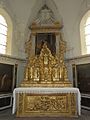
 Froville (M-et-M) Prieuré, église, autel A.jpg 2,736 × 3,648; 3.72 MB
-
 Froville (M-et-M) Prieuré, église, autel B.jpg 2,736 × 3,648; 4.04 MB
-
 Froville (M-et-M) Prieuré, église, extérieur.jpg 3,648 × 2,736; 3.55 MB
-
 Froville (M-et-M) Prieuré, église, intérieur (01).jpg 3,648 × 2,736; 3.42 MB
-
 Froville (M-et-M) Prieuré, église, intérieur (02).jpg 3,648 × 2,736; 3.83 MB
-
 Froville (M-et-M) Prieuré, église, intérieur (03).jpg 3,648 × 2,736; 3.59 MB
-
 Froville (M-et-M) Prieuré, église, statue Saint Nicolas.jpg 2,736 × 3,648; 3.77 MB
-
 Froville (M-et-M) textes jeunes paysans.jpg 2,736 × 3,648; 4.04 MB
-
 Haigneville (M-et-M) city limit sign.jpg 3,648 × 2,736; 3.86 MB
-
 Haigneville (M-et-M) croix de chemin.jpg 3,648 × 2,736; 4.24 MB
-
 Haigneville (M-et-M) fontaine.jpg 2,736 × 3,648; 4.14 MB
-
 Haigneville (M-et-M) mairie.jpg 3,648 × 2,736; 3.97 MB
-
 Haigneville (M-et-M) paysage avec vue du village.jpg 3,648 × 2,736; 4.08 MB
-
 Haigneville (M-et-M) plaque monument aux morts sur la mairie.jpg 2,736 × 3,648; 4.18 MB
-
 Haigneville (M-et-M) église.jpg 3,648 × 2,736; 3.67 MB
-
 Lorey (M-et-M) croix de chemin.jpg 2,736 × 3,648; 4.32 MB
-
 Lorey (M-et-M) fontaine.jpg 3,648 × 2,736; 4.27 MB
-
 Lorey (M-et-M) monument aux morts au cimetière.jpg 2,736 × 3,648; 4.22 MB
-
 Lorey (M-et-M) plaque Charles Joseph Dusaulx.jpg 3,648 × 2,736; 3.39 MB
-
 Lorey (M-et-M) plaque Rue Gabriel Marotel.jpg 3,648 × 2,736; 3.8 MB
-
 Lorey (M-et-M) tombe de guerre.jpg 2,736 × 3,648; 4.32 MB
-
 Lorey (M-et-M) église (02).jpg 3,648 × 2,736; 3.66 MB
-
 Loromontzey (M-et-M) city limit sign hameau Loro.jpg 3,648 × 2,736; 4.28 MB
-
 Loromontzey (M-et-M) city limit sign.jpg 3,648 × 2,736; 3.77 MB
-
 Loromontzey (M-et-M) croix de chemin.jpg 2,736 × 3,648; 3.81 MB
-
 Loromontzey (M-et-M) desus de porte.jpg 2,736 × 3,648; 3.87 MB
-
 Loromontzey (M-et-M) fontaine.jpg 3,648 × 2,736; 4.16 MB
-
 Loromontzey (M-et-M) mairie.jpg 3,648 × 2,736; 3.65 MB
-
 Loromontzey (M-et-M) monument aux morts.jpg 3,648 × 2,736; 3.82 MB
-
 Loromontzey (M-et-M) oratoire.jpg 3,648 × 2,736; 4.35 MB
-
 Loromontzey (M-et-M) paysage hameau Loro.jpg 3,648 × 2,736; 4.26 MB
-
 Loromontzey (M-et-M) paysage.jpg 3,648 × 2,736; 3.78 MB
-
 Loromontzey (M-et-M) église (01).jpg 2,736 × 3,648; 3.59 MB
-
 Loromontzey (M-et-M) église (02).jpg 2,736 × 3,648; 3.53 MB
-
 Méhoncourt (M-et-M) city limit sign.jpg 3,648 × 2,736; 4.26 MB
-
 Méhoncourt (M-et-M) mairie.jpg 3,648 × 2,736; 3.9 MB
-
 Méhoncourt (M-et-M) monument aux morts.jpg 2,736 × 3,648; 4.16 MB
-
 Méhoncourt (M-et-M) mémorial de route.jpg 2,736 × 3,648; 4.32 MB
-
 Méhoncourt (M-et-M) église (01).jpg 2,736 × 3,648; 3.8 MB
-
 Méhoncourt (M-et-M) église (02).jpg 2,736 × 3,648; 3.53 MB
-
 Neuviller-sur-Moselle, (M-et-M) château, mur d'enceinte du domaine.jpg 3,648 × 2,736; 3.6 MB
-
 Neuviller-sur-Moselle, (M-et-M) château.jpg 3,648 × 2,736; 4.17 MB
-
 Neuviller-sur-Moselle, (M-et-M) city limit sign.jpg 3,648 × 2,736; 3.88 MB
-
 Neuviller-sur-Moselle, (M-et-M) croix de mission.jpg 2,736 × 3,648; 4.15 MB
-
 Neuviller-sur-Moselle, (M-et-M) mairie.jpg 3,648 × 2,736; 3.62 MB
-
 Neuviller-sur-Moselle, (M-et-M) monument aux morts.jpg 2,736 × 3,648; 3.84 MB
-
 Neuviller-sur-Moselle, (M-et-M) tombe du prieur Rosselande.jpg 2,736 × 3,648; 4.04 MB
-
 Neuviller-sur-Moselle, (M-et-M) église, extérieur, relief.jpg 2,736 × 3,648; 4.18 MB
-
 Neuviller-sur-Moselle, (M-et-M) église.jpg 3,648 × 2,736; 3.66 MB
-
 Romain (M-et-M) city limit sign.jpg 3,648 × 2,736; 3.72 MB
-
 Romain (M-et-M) mairie et plaque Michelin.jpg 2,736 × 3,648; 4.29 MB
-
 Romain (M-et-M) mairie.jpg 2,896 × 1,968; 2.26 MB
-
 Romain (M-et-M) vue du village.jpg 3,648 × 2,736; 4.18 MB
-
 Roville-devant-Bayon (M-et-M) canal de l'Est, écluse.jpg 3,648 × 2,736; 4.22 MB
-
 Rozelieures (M-et-M) city limit sign D 22D.jpg 3,648 × 2,736; 4.03 MB
-
 Rozelieures (M-et-M) city limit sign D22.jpg 3,648 × 2,736; 4.01 MB
-
 Rozelieures (M-et-M) croix de chemin A.jpg 2,736 × 3,648; 4.25 MB
-
 Rozelieures (M-et-M) croix de chemin B (2).jpg 2,736 × 3,648; 4.18 MB
-
 Rozelieures (M-et-M) croix de chemin C.jpg 2,736 × 3,648; 3.49 MB
-
 Rozelieures (M-et-M) fontaine.jpg 2,736 × 3,648; 4.14 MB
-
 Rozelieures (M-et-M) la Rue Haute.jpg 3,648 × 2,736; 3.82 MB
-
 Rozelieures (M-et-M) lavoir.jpg 3,648 × 2,736; 4.21 MB
-
 Rozelieures (M-et-M) mairie, plaque commémorative Bataille de Rozelieures.jpg 3,648 × 2,736; 3.91 MB
-
 Rozelieures (M-et-M) mairie.jpg 3,648 × 2,736; 3.93 MB
-
 Rozelieures (M-et-M) mémorial Bataille de Rozelieures (01).jpg 3,648 × 2,736; 4.22 MB
-
 Rozelieures (M-et-M) mémorial Bataille de Rozelieures (02).jpg 3,648 × 2,736; 4.29 MB
-
 Rozelieures (M-et-M) mémorial Bataille de Rozelieures (03).jpg 3,648 × 2,736; 4.06 MB
-
 Rozelieures (M-et-M) mémorial Bataille de Rozelieures (04).jpg 2,736 × 3,648; 3.98 MB
-
 Rozelieures (M-et-M) mémorial Bataille de Rozelieures (05).jpg 2,736 × 3,648; 4.15 MB
-
 Rozelieures (M-et-M) mémorial Bataille de Rozelieures (06).jpg 2,736 × 3,648; 4.21 MB
-
 Rozelieures (M-et-M) mémorial Bataille de Rozelieures (07).jpg 3,648 × 2,736; 3.98 MB
-
 Rozelieures (M-et-M) nécropole nationale (01).jpg 3,648 × 2,736; 3.58 MB
-
 Rozelieures (M-et-M) nécropole nationale (02).jpg 3,648 × 2,736; 4.02 MB
-
 Rozelieures (M-et-M) nécropole nationale (03).jpg 3,648 × 2,736; 4.17 MB
-
 Rozelieures (M-et-M) nécropole nationale (04).jpg 3,648 × 2,736; 3.87 MB
-
 Rozelieures (M-et-M) nécropole nationale (05).jpg 3,648 × 2,736; 3.79 MB
-
 Rozelieures (M-et-M) plaque commémorative marquis de Marmier.jpg 3,648 × 2,736; 4.13 MB
-
 Rozelieures (M-et-M) église (01).jpg 2,736 × 3,648; 3.72 MB
-
 Rozelieures (M-et-M) église (02).jpg 2,736 × 3,648; 3.41 MB
-
 Saint-Boingt (M-et-M) city limit sign.jpg 3,648 × 2,736; 4.17 MB
-
 Saint-Boingt (M-et-M) croix de cimetièrer MH.jpg 2,736 × 3,648; 4.21 MB
-
 Saint-Boingt (M-et-M) dessus de porte maison.jpg 3,648 × 2,736; 4.17 MB
-
 Saint-Boingt (M-et-M) fontaine.jpg 3,648 × 2,736; 4.24 MB
-
 Saint-Boingt (M-et-M) mairie.jpg 3,648 × 2,736; 3.74 MB
-
 Saint-Boingt (M-et-M) église (01).jpg 2,736 × 3,648; 3.57 MB
-
 Saint-Boingt (M-et-M) église (02).jpg 2,736 × 3,648; 3.74 MB
-
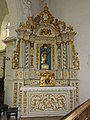
 Saint-Boingt (M-et-M) église, autel central.jpg 2,736 × 3,648; 4.11 MB
-
 Saint-Boingt (M-et-M) église, autel droit.jpg 2,736 × 3,648; 4.16 MB
-
 Saint-Boingt (M-et-M) église, autel gauche.jpg 2,736 × 3,648; 4.13 MB
-
 Saint-Boingt (M-et-M) église, chaire à prêcher.jpg 2,736 × 3,648; 3.74 MB
-
 Saint-Boingt (M-et-M) église, plaque monument aux morts.jpg 3,648 × 2,736; 3.15 MB
-
 Saint-Boingt (M-et-M) église, statue saint Jean Baptiste.jpg 2,736 × 3,648; 3.51 MB
-
 Saint-Boingt (M-et-M) église, vitrail 01.jpg 2,736 × 3,648; 4.12 MB
-
 Saint-Boingt (M-et-M) église, vitrail 02.jpg 2,736 × 3,648; 4.24 MB
-
 Saint-Germain (M-et-M) château-d'eau.jpg 3,648 × 2,736; 3.92 MB
-
 Saint-Germain (M-et-M) croix de chemin A.jpg 2,736 × 3,648; 3.81 MB
-
 Saint-Germain (M-et-M) croix de chemin B.jpg 2,736 × 3,648; 4.09 MB
-
 Saint-Germain (M-et-M) mairie.jpg 3,648 × 2,736; 3.83 MB
-
 Saint-Germain (M-et-M) paysage avec vaches.jpg 3,648 × 2,736; 4.22 MB
-
 Saint-Germain (M-et-M) plaque de cocher, rue de la Fontaine.jpg 2,736 × 3,648; 4.07 MB
-
 Saint-Germain (M-et-M) plaque de cocher, rue Maurice Barrès.jpg 2,736 × 3,648; 4.21 MB
-
 Saint-Germain (M-et-M) église (01).jpg 2,736 × 3,648; 3.71 MB
-
 Saint-Germain (M-et-M) église (02) portail.jpg 3,648 × 2,736; 4.08 MB
-
 Saint-Mard (M-et-M) city limit sign.jpg 3,648 × 2,736; 4.31 MB
-
 Saint-Mard (M-et-M) croix de chemin.jpg 3,648 × 2,736; 4.29 MB
-
 Saint-Mard (M-et-M) gué du ruisseau, rue de la fontaine.jpg 3,648 × 2,736; 4.23 MB
-
 Saint-Mard (M-et-M) mémorial des fusillés.jpg 2,736 × 3,648; 4.25 MB
-
 Saint-Mard (M-et-M) église (01).jpg 3,648 × 2,736; 3.48 MB
-
 Saint-Mard (M-et-M) église (02).jpg 2,736 × 3,648; 3.75 MB
-
 Saint-Mard (M-et-M) église, plaque monument aux morts.jpg 2,736 × 3,648; 3.96 MB
-
 Saint-Rémy-aux-Bois (M-et-M) château-d'eau.jpg 2,736 × 3,648; 4 MB
-
 Saint-Rémy-aux-Bois (M-et-M) city limit sign.jpg 3,648 × 2,736; 4.22 MB
-
 Saint-Rémy-aux-Bois (M-et-M) croix de chemin.jpg 2,736 × 3,648; 4.2 MB
-
 Saint-Rémy-aux-Bois (M-et-M) mairie.jpg 3,648 × 2,736; 3.6 MB
-
 Saint-Rémy-aux-Bois (M-et-M) église (01).jpg 3,648 × 2,736; 3.62 MB
-
 Saint-Rémy-aux-Bois (M-et-M) église (02).jpg 3,648 × 2,736; 3.7 MB
-
 Villacourt (M-et-M) city limit sign.jpg 3,648 × 2,736; 4.03 MB
-
 Villacourt (M-et-M) croix de chemin.jpg 2,736 × 3,648; 4.32 MB
-
 Villacourt (M-et-M) mairie.jpg 3,648 × 2,736; 3.94 MB
-
 Villacourt (M-et-M) monument aux morts.jpg 2,736 × 3,648; 4.18 MB
-
 Villacourt (M-et-M) paysage avec cheval blanc.jpg 3,648 × 2,736; 4.13 MB
-
 Villacourt (M-et-M) église (01).jpg 2,736 × 3,648; 3.82 MB
-
 Villacourt (M-et-M) église (02) portail.jpg 3,648 × 2,736; 3.89 MB
_wind_wheel_(01).jpg)
_wind_wheel_(02).jpg)
_city_limit_sign.jpg)
_dessus_de_porte_maison_A.jpg)
_dessus_de_porte_maison_B.jpg)
_dessus_de_porte_maison_C.jpg)
_lavoir.jpg)
_mairie.jpg)
_%C3%A9glise_(01).jpg)
_%C3%A9glise_(02).jpg)
_city_limit_sign.jpg)
_croix_de_chemin.jpg)
_mairie_-_%C3%A9cole.jpg)
_salle_polyvalente.jpg)
_%C3%A9glise_(01).jpg)
_%C3%A9glise_(02).jpg)
_%C3%A9glise_(03).jpg)
_vue_de_Charmois.jpg)
_city_limit_sign.jpg)
_mairie.jpg)
_monument_aux_morts.jpg)
_%C3%A9glise_(01).jpg)
_%C3%A9glise_(02).jpg)
_%C3%A9glise_(03).jpg)
_%C3%A9glise,_porte_d%27entr%C3%A9e.jpg)
_ch%C3%A2teau.jpg)
_city_limit_sign.jpg)
_Prieur%C3%A9,_%C3%A9glise_portail.jpg)
_Prieur%C3%A9,_%C3%A9glise,_autel_A.jpg)
_Prieur%C3%A9,_%C3%A9glise,_autel_B.jpg)
_Prieur%C3%A9,_%C3%A9glise,_ext%C3%A9rieur.jpg)
_Prieur%C3%A9,_%C3%A9glise,_int%C3%A9rieur_(01).jpg)
_Prieur%C3%A9,_%C3%A9glise,_int%C3%A9rieur_(02).jpg)
_Prieur%C3%A9,_%C3%A9glise,_int%C3%A9rieur_(03).jpg)
_Prieur%C3%A9,_%C3%A9glise,_statue_Saint_Nicolas.jpg)
_textes_jeunes_paysans.jpg)
_city_limit_sign.jpg)
_croix_de_chemin.jpg)
_fontaine.jpg)
_mairie.jpg)
_paysage_avec_vue_du_village.jpg)
_plaque_monument_aux_morts_sur_la_mairie.jpg)
_%C3%A9glise.jpg)
_croix_de_chemin.jpg)
_fontaine.jpg)
_monument_aux_morts_au_cimeti%C3%A8re.jpg)
_plaque_Charles_Joseph_Dusaulx.jpg)
_plaque_Rue_Gabriel_Marotel.jpg)
_tombe_de_guerre.jpg)
_%C3%A9glise_(02).jpg)
_city_limit_sign_hameau_Loro.jpg)
_city_limit_sign.jpg)
_croix_de_chemin.jpg)
_desus_de_porte.jpg)
_fontaine.jpg)
_mairie.jpg)
_monument_aux_morts.jpg)
_oratoire.jpg)
_paysage_hameau_Loro.jpg)
_paysage.jpg)
_%C3%A9glise_(01).jpg)
_%C3%A9glise_(02).jpg)
_city_limit_sign.jpg)
_mairie.jpg)
_monument_aux_morts.jpg)
_m%C3%A9morial_de_route.jpg)
_%C3%A9glise_(01).jpg)
_%C3%A9glise_(02).jpg)
_ch%C3%A2teau,_mur_d%27enceinte_du_domaine.jpg)
_ch%C3%A2teau.jpg)
_city_limit_sign.jpg)
_croix_de_mission.jpg)
_mairie.jpg)
_monument_aux_morts.jpg)
_tombe_du_prieur_Rosselande.jpg)
_%C3%A9glise,_ext%C3%A9rieur,_relief.jpg)
_%C3%A9glise.jpg)
_city_limit_sign.jpg)
_mairie_et_plaque_Michelin.jpg)
_mairie.jpg)
_vue_du_village.jpg)
_canal_de_l%27Est,_%C3%A9cluse.jpg)
_city_limit_sign_D_22D.jpg)
_city_limit_sign_D22.jpg)
_croix_de_chemin_A.jpg)
_croix_de_chemin_B_(2).jpg)
_croix_de_chemin_C.jpg)
_fontaine.jpg)
_la_Rue_Haute.jpg)
_lavoir.jpg)
_mairie,_plaque_comm%C3%A9morative_Bataille_de_Rozelieures.jpg)
_mairie.jpg)
_m%C3%A9morial_Bataille_de_Rozelieures_(01).jpg)
_m%C3%A9morial_Bataille_de_Rozelieures_(02).jpg)
_m%C3%A9morial_Bataille_de_Rozelieures_(03).jpg)
_m%C3%A9morial_Bataille_de_Rozelieures_(04).jpg)
_m%C3%A9morial_Bataille_de_Rozelieures_(05).jpg)
_m%C3%A9morial_Bataille_de_Rozelieures_(06).jpg)
_m%C3%A9morial_Bataille_de_Rozelieures_(07).jpg)
_n%C3%A9cropole_nationale_(01).jpg)
_n%C3%A9cropole_nationale_(02).jpg)
_n%C3%A9cropole_nationale_(03).jpg)
_n%C3%A9cropole_nationale_(04).jpg)
_n%C3%A9cropole_nationale_(05).jpg)
_plaque_comm%C3%A9morative_marquis_de_Marmier.jpg)
_%C3%A9glise_(01).jpg)
_%C3%A9glise_(02).jpg)
_city_limit_sign.jpg)
_croix_de_cimeti%C3%A8rer_MH.jpg)
_dessus_de_porte_maison.jpg)
_fontaine.jpg)
_mairie.jpg)
_%C3%A9glise_(01).jpg)
_%C3%A9glise_(02).jpg)
_%C3%A9glise,_autel_central.jpg)
_%C3%A9glise,_autel_droit.jpg)
_%C3%A9glise,_autel_gauche.jpg)
_%C3%A9glise,_chaire_%C3%A0_pr%C3%AAcher.jpg)
_%C3%A9glise,_plaque_monument_aux_morts.jpg)
_%C3%A9glise,_statue_saint_Jean_Baptiste.jpg)
_%C3%A9glise,_vitrail_01.jpg)
_%C3%A9glise,_vitrail_02.jpg)
_ch%C3%A2teau-d%27eau.jpg)
_croix_de_chemin_A.jpg)
_croix_de_chemin_B.jpg)
_mairie.jpg)
_paysage_avec_vaches.jpg)
_plaque_de_cocher,_rue_de_la_Fontaine.jpg)
_plaque_de_cocher,_rue_Maurice_Barr%C3%A8s.jpg)
_%C3%A9glise_(01).jpg)
_%C3%A9glise_(02)_portail.jpg)
_city_limit_sign.jpg)
_croix_de_chemin.jpg)
_gu%C3%A9_du_ruisseau,_rue_de_la_fontaine.jpg)
_m%C3%A9morial_des_fusill%C3%A9s.jpg)
_%C3%A9glise_(01).jpg)
_%C3%A9glise_(02).jpg)
_%C3%A9glise,_plaque_monument_aux_morts.jpg)
_ch%C3%A2teau-d%27eau.jpg)
_city_limit_sign.jpg)
_croix_de_chemin.jpg)
_mairie.jpg)
_%C3%A9glise_(01).jpg)
_%C3%A9glise_(02).jpg)
_city_limit_sign.jpg)
_croix_de_chemin.jpg)
_mairie.jpg)
_monument_aux_morts.jpg)
_paysage_avec_cheval_blanc.jpg)
_%C3%A9glise_(01).jpg)
_%C3%A9glise_(02)_portail.jpg)