Category:Glen Clova
Jump to navigation
Jump to search
valley in Angus, Scotland, UK | |||||
| Upload media | |||||
| Instance of | |||||
|---|---|---|---|---|---|
| Location | Angus, Scotland | ||||
 | |||||
Subcategories
This category has the following 12 subcategories, out of 12 total.
A
- Acharn, Angus (15 F)
B
C
- Capel Road (3 F)
- Clova Castle (1 F)
- Corrie of Clova (5 F)
H
- Hill of Balbae (1 F)
K
- Kennel Burn (5 F)
R
- Rottal, Angus (13 F)
T
Media in category "Glen Clova"
The following 145 files are in this category, out of 145 total.
-
 A Haugh in Glen Clova - geograph.org.uk - 1743749.jpg 640 × 427; 216 KB
-
 A solitary deer - geograph.org.uk - 510296.jpg 640 × 480; 122 KB
-
 Above the hotel. - geograph.org.uk - 118140.jpg 640 × 480; 78 KB
-
 Adielinn, Glen Clova - geograph.org.uk - 1778950.jpg 800 × 534; 194 KB
-

-
 Animal feeder in stone circle. - geograph.org.uk - 128890.jpg 640 × 424; 113 KB
-
 Ascent of White Hill - geograph.org.uk - 441519.jpg 640 × 480; 98 KB
-
 Atton, Glen Clova - geograph.org.uk - 1780123.jpg 800 × 533; 142 KB
-
 Beyond the Snow Fence - geograph.org.uk - 1744732.jpg 640 × 427; 222 KB
-
 Birch Woods near Inchdowrie - geograph.org.uk - 1744639.jpg 640 × 427; 272 KB
-
 Braemar 14 Miles - geograph.org.uk - 1154138.jpg 640 × 406; 59 KB
-
 Braeminzion - geograph.org.uk - 1743606.jpg 640 × 427; 222 KB
-
 Braeminzion and Whitehillocks - geograph.org.uk - 1743615.jpg 640 × 427; 236 KB
-
 Braeminzion Plantation - geograph.org.uk - 1743594.jpg 640 × 427; 291 KB
-
 Braeminzion, Glen Clova - geograph.org.uk - 1778940.jpg 800 × 534; 201 KB
-
 Brocklas Cottage - geograph.org.uk - 1160736.jpg 640 × 480; 69 KB
-
 Caddam - geograph.org.uk - 118118.jpg 640 × 480; 58 KB
-
 Caddam and Clova - geograph.org.uk - 1743992.jpg 640 × 427; 237 KB
-
 Caddam, Glen Clova - geograph.org.uk - 1780118.jpg 800 × 534; 136 KB
-
 Cairn, Cairn of Barns - geograph.org.uk - 1577298.jpg 640 × 480; 100 KB
-
 Clouds over Glen Clova - geograph.org.uk - 1222077.jpg 640 × 480; 50 KB
-
 Clova - geograph.org.uk - 1743993.jpg 640 × 427; 226 KB
-
 Clova side of Cairn Inks - geograph.org.uk - 1573082.jpg 640 × 359; 84 KB
-
 Clova snow - geograph.org.uk - 1155966.jpg 499 × 640; 71 KB
-
 Clova Snow - geograph.org.uk - 1155979.jpg 640 × 437; 68 KB
-
 Corrie of Wester Lethnot. - geograph.org.uk - 450916.jpg 640 × 480; 59 KB
-
 Corries of Glen Clova - geograph.org.uk - 1577310.jpg 640 × 359; 56 KB
-
 Cows in Glen Clova - geograph.org.uk - 894143.jpg 480 × 640; 113 KB
-
 Crossbog Farm, Glen Clova, Angus - geograph.org.uk - 653588.jpg 640 × 425; 86 KB
-
 Double rainbow over Loch Brandy - geograph.org.uk - 73900.jpg 640 × 427; 51 KB
-
 Down the Glen - geograph.org.uk - 905095.jpg 640 × 480; 65 KB
-
 Early morning in Glen Clova - geograph.org.uk - 35886.jpg 640 × 480; 103 KB
-
 Electricity poles, Glen Clova. - geograph.org.uk - 461193.jpg 640 × 279; 22 KB
-

-
 Fields at Clova - geograph.org.uk - 1744584.jpg 640 × 427; 212 KB
-
 Floor of Glen Clova - geograph.org.uk - 439138.jpg 480 × 640; 87 KB
-
 Forestry in Upper Glen Clova - geograph.org.uk - 1506853.jpg 640 × 480; 80 KB
-
 Gateway on a Glen Clova track - geograph.org.uk - 745927.jpg 640 × 472; 80 KB
-
 Glen Clova (15).jpg 1,200 × 900; 171 KB
-
 Glen Clova (2).jpg 1,200 × 900; 192 KB
-
 Glen Clova (22).jpg 1,200 × 900; 217 KB
-
 Glen Clova (25).jpg 1,200 × 900; 218 KB
-
 Glen Clova (26).jpg 1,200 × 900; 253 KB
-
 Glen Clova (27).jpg 1,200 × 900; 214 KB
-
 Glen Clova (28).jpg 1,200 × 900; 258 KB
-
 Glen Clova (29).jpg 1,200 × 900; 223 KB
-
 Glen Clova (3).jpg 1,200 × 900; 254 KB
-
 Glen Clova (33).jpg 1,200 × 900; 215 KB
-
 Glen Clova (34).jpg 1,200 × 900; 195 KB
-
 Glen Clova (38).jpg 1,200 × 900; 223 KB
-
 Glen Clova (39).jpg 1,200 × 900; 150 KB
-
 Glen Clova (9).jpg 1,200 × 900; 239 KB
-
 Glen Clova - geograph.org.uk - 102170.jpg 640 × 480; 80 KB
-
 Glen Clova - geograph.org.uk - 1055000.jpg 640 × 462; 53 KB
-
 Glen Clova - geograph.org.uk - 105797.jpg 640 × 480; 61 KB
-
 Glen Clova - geograph.org.uk - 1500668.jpg 640 × 480; 64 KB
-
 Glen Clova - geograph.org.uk - 1575420.jpg 640 × 480; 92 KB
-
 Glen Clova - geograph.org.uk - 1575425.jpg 640 × 480; 68 KB
-
 Glen Clova - geograph.org.uk - 1652879.jpg 640 × 480; 66 KB
-
 Glen Clova - geograph.org.uk - 1743674.jpg 640 × 427; 224 KB
-
 Glen Clova - geograph.org.uk - 1743753.jpg 640 × 427; 204 KB
-
 Glen Clova - geograph.org.uk - 1743985.jpg 427 × 640; 235 KB
-
 Glen Clova - geograph.org.uk - 1743995.jpg 640 × 427; 228 KB
-
 Glen Clova - geograph.org.uk - 1744002.jpg 640 × 427; 227 KB
-
 Glen Clova - geograph.org.uk - 1744003.jpg 640 × 427; 242 KB
-
 Glen Clova - geograph.org.uk - 313607.jpg 600 × 399; 46 KB
-
 Glen Clova - geograph.org.uk - 3422.jpg 430 × 640; 37 KB
-
 Glen Clova - geograph.org.uk - 439161.jpg 640 × 480; 81 KB
-
 Glen Clova - geograph.org.uk - 439274.jpg 640 × 480; 98 KB
-
 Glen Clova - geograph.org.uk - 441527.jpg 640 × 442; 66 KB
-
 Glen Clova - geograph.org.uk - 441532.jpg 640 × 480; 67 KB
-
 Glen Clova - geograph.org.uk - 442273.jpg 640 × 480; 89 KB
-
 Glen Clova - geograph.org.uk - 657548.jpg 640 × 198; 27 KB
-
 Glen Clova - geograph.org.uk - 6842.jpg 640 × 480; 123 KB
-
 Glen Clova - geograph.org.uk - 913004.jpg 640 × 480; 99 KB
-
 Glen Clova Beer Festival 2007 - geograph.org.uk - 516584.jpg 640 × 480; 61 KB
-
 Glen Clova from above Moulnie Craig - geograph.org.uk - 1003907.jpg 640 × 480; 50 KB
-
 Glen Clova from Boustie Ley. - geograph.org.uk - 118303.jpg 640 × 480; 83 KB
-
 Glen Clova from near Newbigging - geograph.org.uk - 1743736.jpg 640 × 427; 214 KB
-
 Glen Clova from the lower bridge - geograph.org.uk - 3419.jpg 640 × 430; 34 KB
-
 Glen Clova from Wester Eggie - geograph.org.uk - 1743716.jpg 640 × 427; 224 KB
-
 Glen Clova Hotel - geograph.org.uk - 1154655.jpg 640 × 437; 68 KB
-
 Glen Clova looking north west - geograph.org.uk - 4311.jpg 640 × 480; 53 KB
-
 Glen Clova near Moulzie - geograph.org.uk - 1055010.jpg 455 × 640; 107 KB
-
 Glen Clova near Newbigging - geograph.org.uk - 1780113.jpg 800 × 534; 197 KB
-
 Glen Clova near Newbigging - geograph.org.uk - 1780117.jpg 640 × 427; 68 KB
-
 Glen Clova on the shortest day - geograph.org.uk - 638193.jpg 640 × 480; 53 KB
-
 Glen Clova, from above Bachnagairn. - geograph.org.uk - 411298.jpg 424 × 640; 86 KB
-
 Glen Clova, Kilburn. - geograph.org.uk - 117789.jpg 640 × 480; 73 KB
-
 Glen Clova, slope of boulders - geograph.org.uk - 1500545.jpg 640 × 480; 90 KB
-
 Glen Clova. - geograph.org.uk - 117808.jpg 640 × 480; 93 KB
-
 Glen Clova. - geograph.org.uk - 117833.jpg 640 × 469; 56 KB
-
 Glen Clova. - geograph.org.uk - 118110.jpg 640 × 480; 60 KB
-
 Glen Clova. - geograph.org.uk - 118125.jpg 640 × 480; 78 KB
-
 Glen Clovas Volcano.jpg 1,100 × 825; 155 KB
-
 Grazing in Glen Clova. - geograph.org.uk - 461175.jpg 640 × 575; 70 KB
-
 Horse at Moulzie, Upper Glen Clova - geograph.org.uk - 1058534.jpg 640 × 480; 127 KB
-
 Horses Grazing Upper Glen Clova - geograph.org.uk - 123449.jpg 640 × 424; 114 KB
-

-
 Lone birch tree ,Glen Clova - geograph.org.uk - 1779857.jpg 600 × 440; 99 KB
-
 Looking SW along Glen Clova - geograph.org.uk - 13959.jpg 640 × 480; 107 KB
-
 Looking towards Glen Clova - geograph.org.uk - 894172.jpg 640 × 480; 61 KB
-
 Looking up Glen Clova at Glasslet - geograph.org.uk - 1113149.jpg 640 × 426; 49 KB
-
 Lower Glen Clova - geograph.org.uk - 1743529.jpg 640 × 427; 227 KB
-
 Lower Glen Clova - geograph.org.uk - 296175.jpg 640 × 457; 64 KB
-
 Marchburn - geograph.org.uk - 1155949.jpg 640 × 480; 66 KB
-
 Mill, Clova - geograph.org.uk - 118139.jpg 640 × 480; 117 KB
-
 Moorland south of Manywee - geograph.org.uk - 1005299.jpg 640 × 480; 70 KB
-
 Near Clova - geograph.org.uk - 1744561.jpg 427 × 640; 275 KB
-
 Near the head of the glen - geograph.org.uk - 1055017.jpg 640 × 462; 102 KB
-
 North side of clova from bassies - geograph.org.uk - 766803.jpg 640 × 160; 28 KB
-
 Northern slopes of Cairn of Barns - geograph.org.uk - 1651263.jpg 640 × 470; 89 KB
-
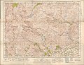 Ordnance Survey One-Inch Sheet 50 Glen Clova & Lochnagar, Published 1946.jpg 12,204 × 9,321; 13.89 MB
-
 Path construction - geograph.org.uk - 118159.jpg 640 × 480; 107 KB
-
 Prosenhaugh (geograph 2157754).jpg 1,500 × 1,125; 611 KB
-

-
 River South Esk - geograph.org.uk - 3424.jpg 640 × 393; 25 KB
-
 River South Esk in Glen Clova - geograph.org.uk - 1743682.jpg 640 × 427; 208 KB
-
 River South Esk towards Moulzie - geograph.org.uk - 792833.jpg 640 × 480; 84 KB
-
 River South Esk. - geograph.org.uk - 117803.jpg 640 × 480; 59 KB
-
 Road Junction in Glen Clova - geograph.org.uk - 1743562.jpg 521 × 640; 292 KB
-
 Road up Glen Clova. - geograph.org.uk - 128900.jpg 640 × 424; 61 KB
-
 Ruin, Glen Clova. - geograph.org.uk - 472227.jpg 640 × 477; 83 KB
-
 Stile near Inchdowrie - geograph.org.uk - 1744632.jpg 427 × 640; 261 KB
-
 The Clova Road - geograph.org.uk - 1058464.jpg 640 × 546; 81 KB
-
 The Clova road, before Clova village. - geograph.org.uk - 472183.jpg 640 × 480; 54 KB
-
-
 The floor of Glen Clova - geograph.org.uk - 442275.jpg 480 × 640; 105 KB
-
 The South Esk - geograph.org.uk - 516635.jpg 480 × 640; 53 KB
-
 The South Esk, Glen Clova. - geograph.org.uk - 516493.jpg 640 × 480; 51 KB
-
 The View from Tarabuckle - geograph.org.uk - 1743660.jpg 640 × 427; 209 KB
-
 The View from the Drums - geograph.org.uk - 1743695.jpg 640 × 427; 188 KB
-
 The View through the Woods - geograph.org.uk - 1744722.jpg 640 × 427; 238 KB
-
 Through the Valley - Flickr - Neillwphoto.jpg 5,829 × 3,875; 15.87 MB
-
 Trees in Glen Clova. - geograph.org.uk - 461159.jpg 480 × 640; 56 KB
-
 Trees near Glenarm, Glen Clova - geograph.org.uk - 1778933.jpg 640 × 427; 59 KB
-
 U-Shaped valley, Glen Clova - geograph.org.uk - 477230.jpg 640 × 424; 96 KB
-
 Upper Glen Clova - geograph.org.uk - 112382.jpg 424 × 640; 67 KB
-
 Upper Glen Clova - geograph.org.uk - 228994.jpg 640 × 480; 93 KB
-

-
 Wall, Upper Glen Clova - geograph.org.uk - 1780132.jpg 800 × 534; 204 KB
-
 Wateresk - geograph.org.uk - 1743627.jpg 640 × 427; 210 KB
-
 Wtf Up Glen Clova.jpg 1,100 × 825; 342 KB
-
 Glen Clova - geograph.org.uk - 170891.jpg 640 × 480; 68 KB
-


.jpg)
.jpg)
.jpg)
.jpg)
.jpg)
.jpg)
.jpg)
.jpg)
.jpg)
.jpg)
.jpg)
.jpg)
.jpg)
.jpg)


.jpg)


_-_geograph.org.uk_-_229194.jpg)


