Category:Geography of Oguni, Kumamoto
Jump to navigation
Jump to search
日本語: 熊本県阿蘇郡小国町の地理
Subcategories
This category has the following 5 subcategories, out of 5 total.
Media in category "Geography of Oguni, Kumamoto"
The following 10 files are in this category, out of 10 total.
-
 Helianthus tuberosus, -in Japan 01.jpg 1,024 × 756; 248 KB
-
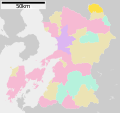 Oguni in Kumamoto Prefecture Ja.svg 527 × 497; 15 KB
-
 Oguni in Kumamoto Prefecture.png 981 × 901; 42 KB
-
 Population distribution of Oguni, Kumamoto, Japan.svg 512 × 256; 22 KB
-
 夫婦杉 - panoramio.jpg 2,112 × 2,816; 2.15 MB
-
 杖立白糸の滝 - panoramio.jpg 2,816 × 2,112; 1.32 MB
-
 竹の熊の大ケヤキ - panoramio.jpg 2,112 × 2,816; 2.21 MB
-
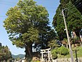 鉾納宮ケヤキ - panoramio.jpg 2,816 × 2,112; 2.84 MB
-
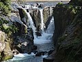 鍋釜滝 - panoramio.jpg 2,816 × 2,112; 2.46 MB
-
 阿弥陀杉 - panoramio.jpg 2,816 × 2,112; 2.14 MB


