Category:Geography of Kenya
Jump to navigation
Jump to search
why weather forecasting is important | |||||
| Upload media | |||||
| Instance of |
| ||||
|---|---|---|---|---|---|
| Subclass of | |||||
| Facet of | |||||
| Location |
| ||||
| Highest point |
| ||||
| Area |
| ||||
 | |||||
Subcategories
This category has the following 17 subcategories, out of 17 total.
B
E
- Equator in Kenya (8 F)
G
L
M
P
S
- Savanna in Kenya (22 F)
T
U
- Underwater in Kenya (2 F)
- Urbanization in Kenya (4 F)
W
Pages in category "Geography of Kenya"
This category contains only the following page.
Media in category "Geography of Kenya"
The following 25 files are in this category, out of 25 total.
-
Aiyangiyang mud polygons.jpg 450 × 295; 132 KB
-
Area of Kenya in the Southern Hemisphere.png 955 × 645; 255 KB
-
Athifloden.png 961 × 738; 115 KB
-
Brick construction samburu.jpg 567 × 379; 62 KB
-
Burial in the Storm.jpg 1,280 × 960; 1.48 MB
-
Chalbi Desert Panorama.jpg 2,997 × 1,333; 1.37 MB
-
Dhows in Kilifi Creek.JPG 1,000 × 1,500; 428 KB
-
KangaSiyu1.jpg 1,704 × 2,272; 766 KB
-
KE-Busia.png 488 × 572; 8 KB
-
KE-Isiolo.png 488 × 572; 8 KB
-
KE-Maralal.png 488 × 572; 7 KB
-
KE-Marsabit.png 488 × 572; 8 KB
-
KE-Webuye.png 488 × 572; 7 KB
-
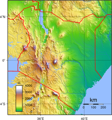
Kenya Topography.png 1,229 × 1,315; 2.33 MB
-
Kenya-Eastern.png 488 × 572; 7 KB
-
Kenya-Nyanza.png 488 × 572; 7 KB
-
Loita plains and hills.jpg 3,022 × 1,488; 1.22 MB
-
Map showing counties under the new Kenyan constitution.gif 620 × 804; 56 KB
-
Marafa Depression 2011.JPG 640 × 480; 142 KB
-
Nanyuki main street.jpg 1,000 × 750; 434 KB
-
Rift valley panorama (5232661210).jpg 2,048 × 485; 1.06 MB
-
Shimoni & Wasini.jpg 773 × 575; 168 KB
-
Siyu town at low tide..JPG 1,024 × 608; 139 KB
-
Stone pit near Marsabit, North Kenya.jpg 3,456 × 2,592; 4.04 MB
-
Tracks Chalbi Desert.jpg 3,000 × 1,753; 5 MB


