Category:Gare de Saint-Amand-Montrond - Orval
Jump to navigation
Jump to search
| Object location | | View all coordinates using: OpenStreetMap |
|---|
railway station in Orval, France  | |||||
| Upload media | |||||
| Instance of | |||||
|---|---|---|---|---|---|
| Location | Orval, Cher, Centre-Val de Loire, Metropolitan France, France | ||||
| Transport network | |||||
| Owned by | |||||
| Operator | |||||
| Date of official opening |
| ||||
| Elevation above sea level |
| ||||
| Connecting line | |||||
| Adjacent station | |||||
 | |||||
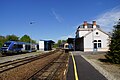
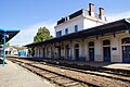
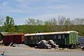
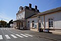
Français : La gare de Saint-Amand-Montrond - Orval est une gare ferroviaire française de la ligne de Bourges à Miécaze, située sur le territoire de la commune d'Orval, près de Saint-Amand-Montrond, dans le département du Cher, en région Centre.
Media in category "Gare de Saint-Amand-Montrond - Orval"
The following 15 files are in this category, out of 15 total.
-
 Gare-Saint-Amand-Montrond-Orval-BV-2016.jpg 6,000 × 4,000; 12.3 MB
-
 Gare-St-Amand-Montrond-1900.jpg 971 × 608; 479 KB
-
 GareStAmandMontrond-HalleMarchandises.jpg 6,000 × 4,000; 4.94 MB
-
 GareStAmandMontrond2016 01.jpg 6,000 × 4,000; 4.17 MB
-
 GareStAmandMontrond2016 02.jpg 6,000 × 4,000; 4.13 MB
-
 GareStAmandMontrond2016 03.jpg 6,000 × 4,000; 4.83 MB
-
 GareStAmandMontrond2016 04.jpg 6,000 × 4,000; 4.2 MB
-
 GareStAmandMontrond2016 05.jpg 6,000 × 4,000; 3.71 MB
-
 GareStAmandMontrond2016 06.jpg 6,000 × 4,000; 2.49 MB
-
 GareStAmandMontrond2016 07.jpg 6,000 × 4,000; 4.55 MB
-
 GareStAmandMontrond2016 08.jpg 6,000 × 4,000; 3.94 MB
-
 GareStAmandMontrond2016 09.jpg 6,000 × 4,000; 3.73 MB
-
 GareStAmandMontrond2016 10.jpg 6,000 × 4,000; 4.27 MB
-
 GareStAmandMontrond2016 11.jpg 6,000 × 4,000; 3.79 MB
-
 GareStAmandMontrond2016 12.jpg 6,000 × 4,000; 5.43 MB


