Category:French Polynesia in the 18th century
Jump to navigation
Jump to search
Departments of Metropolitan France: Ain [01] · Aisne [02] · Alpes-de-Haute-Provence [04] · Hautes-Alpes [05] · Alpes-Maritimes [06] · Ardèche [07] · Ardennes [08] · Ariège [09] · Aube [10] · Aude [11] · Bouches-du-Rhône [13] · Calvados [14] · Charente [16] · Charente-Maritime [17] · Corrèze [19] · Côte-d’Or [21] · Dordogne [24] · Doubs [25] · Drôme [26] · Eure [27] · Eure-et-Loir [28] · Finistère [29] · Gard [30] · Haute-Garonne [31] · Gironde [33] · Hérault [34] · Ille-et-Vilaine [35] · Indre-et-Loire [37] · Isère [38] · Jura [39] · Loir-et-Cher [41] · Loire-Atlantique [44] · Loiret [45] · Lot-et-Garonne [47] · Lozère [48] · Manche [50] · Marne [51] · Haute-Marne [52] · Meurthe-et-Moselle [54] · Meuse [55] · Morbihan [56] · Moselle [57] · Nièvre [58] · Nord [59] · Oise [60] · Orne [61] · Pas-de-Calais [62] · Pyrénées-Atlantiques [64] · Hautes-Pyrénées [65] · Bas-Rhin [67] · Haut-Rhin [68] · Saône-et-Loire [71] · Savoie [73] · Haute-Savoie [74] · Paris [75] · Seine-Maritime [76] · Seine-et-Marne [77] · Yvelines [78] · Deux-Sèvres [79] · Var [83] · Vaucluse [84] · Vendée [85] · Vosges [88] · Yonne [89] · Hauts-de-Seine [92] · Val-de-Marne [94]
Overseas departments and regions: Guadeloupe [971] · Martinique [972] · French Guiana [973] · Réunion [974] · Mayotte [976]
Overseas collectivities: French Polynesia [987]
Sui generis territories: New Caledonia [988]
Overseas departments and regions: Guadeloupe [971] · Martinique [972] · French Guiana [973] · Réunion [974] · Mayotte [976]
Overseas collectivities: French Polynesia [987]
Sui generis territories: New Caledonia [988]
Administrative regions and territorial collectivity of Metropolitan France (‡ since start of 2016):
Auvergne-Rhône-Alpes‡ · Bourgogne-Franche-Comté‡ · Brittany · Centre-Val de Loire · Corsica · Grand Est‡ · Hauts-de-France‡ · Île-de-France · Normandy‡ · Nouvelle-Aquitaine‡ · Occitania‡ · Pays de la Loire · Provence-Alpes-Côte d'Azur
Former administrative regions of Metropolitan France (until end of 2015):
Alsace · Auvergne · Burgundy · Champagne-Ardenne · Languedoc-Roussillon · Limousin · Lorraine · Midi-Pyrénées · Picardy
Overseas departments and regions: Guadeloupe · Martinique · French Guiana · Réunion · Mayotte
Overseas collectivities: French Polynesia
Sui generis territories: New Caledonia
Countries of Oceania: Australia · Fiji · Federated States of Micronesia · New Zealand · Palau · Papua New Guinea · Samoa · Solomon Islands · Tonga · Vanuatu
Other areas: American Samoa · Cook Islands · French Polynesia · Guam · Hawaii · New Caledonia – Partly: Indonesia
Other areas: American Samoa · Cook Islands · French Polynesia · Guam · Hawaii · New Caledonia – Partly: Indonesia
Subcategories
This category has the following 3 subcategories, out of 3 total.
Media in category "French Polynesia in the 18th century"
The following 22 files are in this category, out of 22 total.
-
 1769 Cook Map of the Society Islands - Geographicus - SoecityIsland-cook-1769.jpg 4,000 × 2,708; 2.29 MB
-
 An unlabeled scene in the Society Island, 1769-71 (crop of dog).jpg 792 × 1,126; 231 KB
-
 Carte Bougainville aux Tuamotus 1768.jpg 2,903 × 1,760; 748 KB
-
 Carte Bougainville détail Harpe 1768.jpg 330 × 221; 33 KB
-
 Carte Bougainville détail Lanciers-Facardins 1768.jpg 308 × 203; 26 KB
-
 Carte de l'isle de Taiti par le Lieutenant J. Cook, 1769 (19386164889).jpg 6,930 × 4,241; 3.97 MB
-
 Carte des isles de la Societé découvertes par le Lieutenant J. Cook, 1769 (19572710145).jpg 6,968 × 4,536; 4.46 MB
-
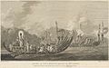 Engraving of 'The Fleet of Otaheite Assembled at Oparee'.jpg 1,000 × 628; 87 KB
-
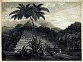 Great Morai of Temarre at Pappara in Otaheite (retouched).jpg 3,520 × 2,652; 8.4 MB
-
 Great Morai of Temarre at Pappara in Otaheite.jpg 3,637 × 2,903; 1.94 MB
-

-
 John Cleveley the Younger, Views of the South Seas (No. 1 of 4).png 920 × 672; 776 KB
-
 John Cleveley the Younger, Views of the South Seas (No. 3 of 4).jpg 3,308 × 2,422; 860 KB
-
 Natives outside burial hut with oheines. Huahine.jpg 1,280 × 784; 441 KB
-
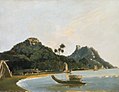
 Samuel Wallis, York Island (c. 1767).jpg 562 × 352; 22 KB
-
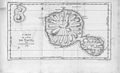
 Tahiti 18th century map.jpg 500 × 306; 47 KB
-
 Vessels of the Island of Otaha, 1769-71.jpg 2,256 × 1,429; 959 KB
-
 View of the Island of Otaha, 1769-71 (crop of dog).jpg 789 × 1,150; 295 KB
-
 View of the Island of Otaha, 1769-71.jpg 2,252 × 1,506; 954 KB
-
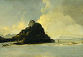
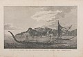 Vue de la Baye de la Resolution dans l'Isle des Marquises.jpg 1,024 × 708; 135 KB
-
-

.jpg)


.jpg)
.jpg)

.jpg)

_One_of_the_Friendly_Islands_in_the_South_Seas.jpg)
.png)
.jpg)

.jpg)


.jpg)


_Harbour,_Island_of_Huahine,_1773.jpg)
_Harbour,_Island_of_Huahine,_1774.jpg)