Category:Foulridge
Jump to navigation
Jump to search
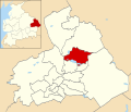
English: Foulridge (pronounced "foalridge") is a small village and civil parish in Pendle, Lancashire, close to the border with North Yorkshire in England. It is situated just beyond Colne, on the route from the M65 to Skipton, and is an important stopping point on summit pound of the Leeds-Liverpool Canal, just before it enters the Foulridge Tunnel. Noyna Hill, a well known local landmark, sits east of the village. (→Foulridge)
Nederlands: Foulridge is een plaats en civil parish in het bestuurlijke gebied Pendle, in het Engelse graafschap Lancashire met 1.506 inwoners. (→Foulridge)
Polski: Foulridge – wieś w Anglii, w hrabstwie Lancashire, w dystrykcie Pendle. Leży 45 km na północ od miasta Manchester i 296 km na północny zachód od Londynu. W 2001 miejscowość liczyła 1506 mieszkańców. (→Foulridge)
village and civil parish in Lancashire, England | |||||
| Upload media | |||||
| Instance of | |||||
|---|---|---|---|---|---|
| Location | Pendle, Lancashire, North West England, England | ||||
| Population |
| ||||
 | |||||
Subcategories
This category has the following 6 subcategories, out of 6 total.
Media in category "Foulridge"
The following 200 files are in this category, out of 353 total.
(previous page) (next page)-
A play area off Sycamore Rise, Foulridge - geograph.org.uk - 2104825.jpg 800 × 600; 327 KB
-
A sewage works near Foulridge - geograph.org.uk - 2104777.jpg 800 × 600; 325 KB
-
A56 entering Foulridge - geograph.org.uk - 3087786.jpg 640 × 421; 51 KB
-
A56 towards Foulridge - geograph.org.uk - 5964437.jpg 640 × 390; 82 KB
-
Abner Row, Foulridge - geograph.org.uk - 3163798.jpg 424 × 640; 56 KB
-
Accornlee Hall farm from A56 - geograph.org.uk - 3087785.jpg 640 × 413; 61 KB
-
Alma Avenue Play Area, Foulridge.jpg 1,024 × 678; 854 KB
-
Alma Avenue, Foulridge, Lancashire - geograph.org.uk - 878298.jpg 640 × 427; 58 KB
-
Approaching White House - geograph.org.uk - 1165825.jpg 640 × 480; 89 KB
-
B6251 approaching junction - geograph.org.uk - 5873255.jpg 640 × 465; 62 KB
-
Benchmark on Daubers Bridge - geograph.org.uk - 3251104.jpg 2,048 × 1,536; 544 KB
-
Benchmark on Hollinhurst Bridge - geograph.org.uk - 3251099.jpg 2,048 × 1,536; 722 KB
-
Benchmark on Mill Hill Bridge - geograph.org.uk - 3251086.jpg 2,048 × 1,536; 505 KB
-
Boating on the reservoir - geograph.org.uk - 5729890.jpg 4,320 × 3,240; 3.94 MB
-
Bridge crossing the Wanless Water - geograph.org.uk - 5955241.jpg 640 × 517; 107 KB
-
Bridge over Slipper Hill Clough - geograph.org.uk - 5810043.jpg 1,024 × 768; 332 KB
-
Building on Sycamore Rise, Foulridge - geograph.org.uk - 3163927.jpg 640 × 424; 66 KB
-
Burwain Sailing Club - geograph.org.uk - 4096722.jpg 640 × 481; 284 KB
-
Bus shelter on Whitemoor Road - geograph.org.uk - 3165295.jpg 640 × 478; 131 KB
-
Cafe Cargo - geograph.org.uk - 4574240.jpg 2,560 × 1,920; 2.67 MB
-
Cafe Cargo at Foulridge - geograph.org.uk - 2120470.jpg 640 × 480; 86 KB
-
Café Cargo at Foulridge - geograph.org.uk - 5955696.jpg 640 × 439; 79 KB
-
Café Cargo at Foulridge Wharf - geograph.org.uk - 1766256.jpg 640 × 427; 99 KB
-
Canalside House, Foulridge - geograph.org.uk - 1577172.jpg 640 × 480; 92 KB
-
Canalside lime kiln at Foulridge - geograph.org.uk - 5729934.jpg 3,240 × 4,320; 3.68 MB
-
Causeway on Upper Foulridge Reservoir - geograph.org.uk - 2402051.jpg 1,600 × 1,198; 470 KB
-
Causeway, Foulridge - geograph.org.uk - 3163926.jpg 640 × 424; 67 KB
-
Causeway, Foulridge, Lancashire - geograph.org.uk - 878611.jpg 640 × 427; 84 KB
-
Chapel House, County Brook Lane - geograph.org.uk - 3165301.jpg 640 × 480; 155 KB
-
Close up, Elizabeth II postbox on the B6251, Hill Top - geograph.org.uk - 5873623.jpg 2,315 × 3,306; 1.57 MB
-
Cob Lane - geograph.org.uk - 1148230.jpg 640 × 448; 76 KB
-
Cob Lane - geograph.org.uk - 2223903.jpg 2,592 × 1,944; 1.62 MB
-
Cob Lane - geograph.org.uk - 5877333.jpg 640 × 480; 108 KB
-
Cockhill Lane at Causeway Top - geograph.org.uk - 5470403.jpg 4,000 × 3,000; 4.88 MB
-
Colne, Bywash (overflow) from Foulridge Upper Reservoir - geograph.org.uk - 2390655.jpg 3,456 × 2,304; 5.51 MB
-
Colne, Kirk Bridge - geograph.org.uk - 2390648.jpg 3,456 × 2,304; 5.43 MB
-
County Bridge - geograph.org.uk - 694752.jpg 640 × 529; 143 KB
-
County Brook Lane - geograph.org.uk - 3165303.jpg 640 × 480; 206 KB
-
County Brook Mill - geograph.org.uk - 5223768.jpg 6,000 × 4,000; 5.02 MB
-
County Mill - geograph.org.uk - 695052.jpg 640 × 613; 111 KB
-
Croft Mill, Foulridge - geograph.org.uk - 3165282.jpg 640 × 480; 128 KB
-
Cromwell Street, Foulridge - geograph.org.uk - 1160404.jpg 640 × 480; 79 KB
-
Cromwell Street, Foulridge - geograph.org.uk - 3163811.jpg 640 × 424; 69 KB
-
Cromwell Street, Foulridge - geograph.org.uk - 3165283.jpg 480 × 640; 82 KB
-
Cross (5878575364).jpg 2,371 × 4,137; 7.46 MB
-
Cross in Foulridge churchyard (5951269041).jpg 2,606 × 3,909; 6.79 MB
-
Development land in Foulridge - geograph.org.uk - 5227935.jpg 6,000 × 4,000; 3.86 MB
-
Dinghies on Foulridge reservoir - geograph.org.uk - 1262728.jpg 640 × 480; 78 KB
-
Direction Sign – Signpost in Foulridge - geograph.org.uk - 6523893.jpg 594 × 792; 202 KB
-
Direction Sign – Signpost in Foulridge - geograph.org.uk - 6687926.jpg 648 × 1,178; 198 KB
-
Dismantled railway, Foulridge - geograph.org.uk - 3165277.jpg 640 × 424; 82 KB
-
Distressed Wall beneath Slipper Hill Reservoir - geograph.org.uk - 2439569.jpg 4,320 × 3,240; 4.23 MB
-
Disused railway - geograph.org.uk - 144122.jpg 640 × 480; 148 KB
-
Disused railway bridge near Slipper Hill Reservoir - geograph.org.uk - 2402491.jpg 1,600 × 1,198; 831 KB
-
Elizabeth II postbox on the B6251, Hill Top - geograph.org.uk - 5873622.jpg 3,319 × 2,190; 1,001 KB
-
Elizabeth II postbox on Towngate, Foulridge - geograph.org.uk - 5873631.jpg 2,217 × 3,236; 1.11 MB
-
Entrance to Long Hill Farm - geograph.org.uk - 2402439.jpg 1,600 × 1,198; 733 KB
-
Farm track off Standing Stone Lane - geograph.org.uk - 5873280.jpg 640 × 480; 99 KB
-
Farmhouse at Moss Houses - geograph.org.uk - 2402058.jpg 1,600 × 1,198; 388 KB
-
Field footpath approaching a wall stile and gateway - geograph.org.uk - 6086878.jpg 4,000 × 3,000; 4.51 MB
-
Fields below Foulridge - geograph.org.uk - 5215040.jpg 6,000 × 4,000; 3.87 MB
-
Fields near the canal - geograph.org.uk - 2120698.jpg 640 × 480; 127 KB
-
Fields near the canal - geograph.org.uk - 2120705.jpg 640 × 480; 89 KB
-
Fieldscape near Foulridge Wharf - geograph.org.uk - 643323.jpg 640 × 480; 88 KB
-
Footbridge over field dyke - geograph.org.uk - 5422964.jpg 4,032 × 3,024; 2.85 MB
-
Footpath alongside Foulridge Lower Reservoir - geograph.org.uk - 3251110.jpg 2,048 × 1,536; 614 KB
-
Footpath into Foulridge - geograph.org.uk - 5729905.jpg 2,957 × 3,709; 3.57 MB
-
Footpath leading towards Kelbrook Wood - geograph.org.uk - 2324942.jpg 4,320 × 3,240; 6.13 MB
-
Footpath near Foulridge - geograph.org.uk - 5215050.jpg 6,000 × 4,000; 4.22 MB
-
Ford on Cockhill Lane - geograph.org.uk - 5877334.jpg 640 × 480; 106 KB
-
Ford on Cockhill Lane - geograph.org.uk - 5877335.jpg 640 × 480; 117 KB
-
Foulridge 01.jpg 2,560 × 1,920; 2.57 MB
-
Foulridge 02.jpg 2,560 × 1,920; 2.51 MB
-
Foulridge 03.jpg 2,560 × 1,920; 2.49 MB
-
Foulridge Ford - geograph.org.uk - 4289218.jpg 3,872 × 2,592; 4.27 MB
-
Foulridge Hall Farm - geograph.org.uk - 5729928.jpg 4,320 × 3,240; 4.48 MB
-
Foulridge Lower Reservoir (Lake Burwain) - geograph.org.uk - 4096736.jpg 640 × 480; 302 KB
-
Foulridge lower reservoir - geograph.org.uk - 1400869.jpg 640 × 480; 85 KB
-
Foulridge lower reservoir - geograph.org.uk - 2066997.jpg 800 × 533; 243 KB
-
Foulridge Lower Reservoir - geograph.org.uk - 5224771.jpg 6,000 × 4,000; 7.81 MB
-
Foulridge Lower Reservoir - geograph.org.uk - 5224785.jpg 6,000 × 4,000; 3.98 MB
-
Foulridge Lower Reservoir - geograph.org.uk - 5729861.jpg 4,320 × 2,826; 3.17 MB
-
Foulridge Lower Reservoir - geograph.org.uk - 5729874.jpg 4,320 × 3,240; 3.24 MB
-
Foulridge Lower Reservoir, Lake Burwain - geograph.org.uk - 4096733.jpg 640 × 480; 319 KB
-
Foulridge reservoirs - geograph.org.uk - 3864900.jpg 640 × 480; 146 KB
-
Foulridge Social Club - geograph.org.uk - 3163790.jpg 640 × 424; 57 KB
-
Foulridge station, Lancashire - geograph.org.uk - 625121.jpg 640 × 518; 82 KB
-
Foulridge UK ward locator map.svg 1,425 × 1,214; 313 KB
-
Foulridge upper reservoir - geograph.org.uk - 2067004.jpg 800 × 533; 315 KB
-
Foulridge Upper Reservoir - geograph.org.uk - 2123961.jpg 4,592 × 3,056; 5.22 MB
-
Foulridge Village Hall - geograph.org.uk - 3163819.jpg 640 × 424; 72 KB
-
Foulridge village, Lancashire - geograph.org.uk - 191951.jpg 640 × 480; 78 KB
-
Foulridge village, near Burnley - geograph.org.uk - 28372.jpg 640 × 480; 103 KB
-
Foulridge, Close House - geograph.org.uk - 2394717.jpg 3,456 × 2,304; 4.16 MB
-
Foulridge, Cromwell Street - geograph.org.uk - 1801849.jpg 3,456 × 2,304; 6.06 MB
-
Foulridge, Lancashire - Barnoldswick Road - geograph.org.uk - 1802443.jpg 3,456 × 2,304; 6.35 MB
-
Foulridge, Lancashire - Cragg Nook - geograph.org.uk - 1802625.jpg 2,880 × 1,920; 3.68 MB
-
Foulridge, Lancashire - geograph.org.uk - 1801799.jpg 2,400 × 1,600; 2.05 MB
-
Foulridge, Lancashire, 2-10 Warehouse Lane - geograph.org.uk - 1802417.jpg 3,408 × 2,208; 6.01 MB
-
Foulridge, Lancashire, Abner Row - geograph.org.uk - 1801848.jpg 3,456 × 2,304; 5.12 MB
-
Foulridge, Lancashire, An old road - geograph.org.uk - 1801807.jpg 3,456 × 2,304; 6.71 MB
-
Foulridge, Lancashire, Chapel Street - geograph.org.uk - 1801777.jpg 3,192 × 2,200; 5.19 MB
-
Foulridge, Lancashire, Cromwell Street - geograph.org.uk - 1801819.jpg 2,238 × 2,928; 3.99 MB
-
Foulridge, Lancashire, House backs, Parkinson Street - geograph.org.uk - 1801781.jpg 3,456 × 2,304; 5.49 MB
-
Foulridge, Lancashire, House opposite the canal - geograph.org.uk - 1922253.jpg 3,264 × 2,448; 7.08 MB
-
Foulridge, Lancashire, Mile End Close - geograph.org.uk - 1802465.jpg 3,456 × 2,304; 5.83 MB
-
Foulridge, Lancashire, Old quarry - geograph.org.uk - 1802601.jpg 2,304 × 1,536; 1.96 MB
-
Foulridge, Lancashire, Ormerod Terrace - geograph.org.uk - 1801695.jpg 3,456 × 2,304; 4.74 MB
-
Foulridge, Lancashire, Station Road - geograph.org.uk - 1801852.jpg 3,456 × 2,304; 5.63 MB
-
Foulridge, Lancashire, The 'New Inn' - geograph.org.uk - 1802641.jpg 3,052 × 1,912; 4.22 MB
-
Foulridge, Lancashire, The Old Sidings - geograph.org.uk - 1802497.jpg 3,456 × 2,304; 5.66 MB
-
Foulridge, Lancashire, Top of Towngate - geograph.org.uk - 1802354.jpg 3,456 × 2,304; 5.45 MB
-
Foulridge, Lancashire, Towngate - geograph.org.uk - 1802389.jpg 3,456 × 2,304; 6.21 MB
-
Foulridge, Lancashire, Track of former railway - geograph.org.uk - 1802523.jpg 3,456 × 2,304; 7.11 MB
-
Foulridge, Lancashire, Track of former railway - geograph.org.uk - 1802564.jpg 2,400 × 1,600; 2.2 MB
-
Foulridge, Lancashire, Warehouse Lane - geograph.org.uk - 1801830.jpg 3,456 × 2,304; 5.88 MB
-
Foulridge, Not an old house on Skipton Road - geograph.org.uk - 2394695.jpg 3,456 × 2,304; 4.34 MB
-
Foulridge,Lancashire, Causeway - geograph.org.uk - 1802664.jpg 3,052 × 2,216; 5.29 MB
-
Garden at Ball House - geograph.org.uk - 2402456.jpg 1,600 × 1,198; 868 KB
-
Grazing land below the Leeds ^ Liverpool Canal - geograph.org.uk - 5223784.jpg 6,000 × 4,000; 3.95 MB
-
Grazing near Throstle Nest Farm - geograph.org.uk - 5877331.jpg 640 × 480; 67 KB
-
Grazing towards Long Hill Farm - geograph.org.uk - 5873290.jpg 640 × 480; 63 KB
-
Green at Foulridge - geograph.org.uk - 2223891.jpg 2,592 × 1,944; 1.56 MB
-
Green space on Towngate, Foulridge - geograph.org.uk - 3163814.jpg 640 × 424; 102 KB
-
Hare & Hounds, Foulridge - geograph.org.uk - 4096136.jpg 640 × 480; 268 KB
-
Hare and Hounds, Foulridge - geograph.org.uk - 1584859.jpg 640 × 480; 49 KB
-
Hey Fold cottage - geograph.org.uk - 2402426.jpg 1,600 × 1,198; 761 KB
-
High Lane (B6251) - geograph.org.uk - 5873250.jpg 640 × 480; 66 KB
-
High Lane near County Brook Lane - geograph.org.uk - 3165300.jpg 640 × 480; 163 KB
-
High Lane near Lark Hill Farm - geograph.org.uk - 5215666.jpg 6,000 × 4,000; 3.27 MB
-
Hillside grazing off Cob Lane - geograph.org.uk - 5877330.jpg 640 × 480; 61 KB
-
"Hole in the Wall" - geograph.org.uk - 1577154.jpg 640 × 430; 67 KB
-
Holly Bush Farm - geograph.org.uk - 2439555.jpg 4,320 × 3,240; 4.66 MB
-
House on Whitemoor Road (B6251) - geograph.org.uk - 5873292.jpg 640 × 480; 82 KB
-
House, Standing Stone Gate - geograph.org.uk - 5873275.jpg 640 × 480; 81 KB
-
Houses in Foulridge - geograph.org.uk - 2120504.jpg 640 × 480; 68 KB
-
Houses on Skipton Road - geograph.org.uk - 5873383.jpg 640 × 480; 66 KB
-
Houses on Towngate, Foulridge - geograph.org.uk - 5873297.jpg 640 × 480; 71 KB
-
Houses, Foulridge - geograph.org.uk - 5873371.jpg 640 × 416; 60 KB
-
Housing in Foulridge - geograph.org.uk - 2120501.jpg 640 × 480; 93 KB
-
Housing on the green in Foulridge - geograph.org.uk - 2120494.jpg 640 × 480; 112 KB
-
In Fields East of Foulridge - geograph.org.uk - 1165856.jpg 640 × 480; 92 KB
-
Ivegate, Foulridge - geograph.org.uk - 3163840.jpg 640 × 424; 76 KB
-
Ivegate, Foulridge - geograph.org.uk - 5227926.jpg 6,000 × 4,000; 7.27 MB
-
Lake Burwain (Foulridge Lower Reservoir) - panoramio (1).jpg 2,052 × 1,920; 584 KB
-
Lake Burwain (Foulridge Lower Reservoir) - panoramio.jpg 2,004 × 1,794; 356 KB
-
Lake Burwain (Lower Foulridge Reservoir) - geograph.org.uk - 4096709.jpg 640 × 482; 318 KB
-
Lake Burwain - panoramio.jpg 2,560 × 1,920; 2.55 MB
-
Large house on Skipton Road - geograph.org.uk - 5873385.jpg 640 × 480; 98 KB
-
Looking north along A56 at Foulridge - geograph.org.uk - 4775267.jpg 1,024 × 683; 220 KB
-
Low Well, Foulridge, Lancashire - geograph.org.uk - 878898.jpg 640 × 480; 108 KB
-
Lower Foulridge Reservoir - geograph.org.uk - 2104018.jpg 800 × 600; 189 KB
-
Lower Foulridge Reservoir - geograph.org.uk - 4096690.jpg 640 × 480; 297 KB
-
Metalled access off Reedymoor Lane - geograph.org.uk - 1160418.jpg 640 × 480; 80 KB
-
Milepost on the Leeds Liverpool Canal - geograph.org.uk - 2120732.jpg 480 × 640; 147 KB
-
Muddy track off Cob Lane - geograph.org.uk - 1148233.jpg 640 × 480; 85 KB
-
New Hague to Barnoldswick - geograph.org.uk - 4825073.jpg 3,648 × 2,736; 4.37 MB
-
Noyna Ford - geograph.org.uk - 4289267.jpg 3,872 × 2,592; 4.32 MB
-
Noyna Road near Higher Broach - geograph.org.uk - 5470407.jpg 4,000 × 3,000; 3.58 MB
-
Old Boundary Marker - geograph.org.uk - 6444089.jpg 570 × 761; 233 KB
-
Open country behind industrial units - geograph.org.uk - 5923992.jpg 2,250 × 1,501; 3.59 MB
-
Ordnance Survey Cut Mark - geograph.org.uk - 3008923.jpg 4,000 × 3,000; 4.86 MB
-
Parkinson Street, Foulridge - geograph.org.uk - 3163825.jpg 640 × 424; 67 KB
-
Part of the missing link - geograph.org.uk - 5729824.jpg 3,239 × 4,319; 5.25 MB
-
Pasture Drive, Foulridge - geograph.org.uk - 2104809.jpg 800 × 600; 259 KB
-
Pastureland east of the canal - geograph.org.uk - 5730197.jpg 4,320 × 3,240; 3.74 MB
-
Pastures near Hey Fold - geograph.org.uk - 2439180.jpg 4,320 × 3,240; 3.44 MB
-
Path below Foulridge - geograph.org.uk - 5224774.jpg 6,000 × 4,000; 4.99 MB
-
Path to Skipton Road - geograph.org.uk - 5224790.jpg 6,000 × 4,000; 4.74 MB
-
Path towards St Michael's Church - geograph.org.uk - 4096745.jpg 640 × 480; 373 KB
-
Pendle Polymer Group, Foulridge - geograph.org.uk - 2120474.jpg 640 × 480; 67 KB
-
Pendle View, Foulridge, Lancashire - geograph.org.uk - 878287.jpg 640 × 427; 74 KB
-
Postbox along Reedymoor Lane - geograph.org.uk - 5955297.jpg 640 × 422; 96 KB
-
Pre-Worboys Road Sign - geograph.org.uk - 5904404.jpg 683 × 1,024; 197 KB
-
Railway Street, Foulridge - geograph.org.uk - 3165291.jpg 480 × 640; 74 KB


