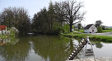
Category:Fossa Carolina
Jump to navigation
Jump to search
This is the category of the Bavarian Baudenkmal (cultural heritage monument) with the ID E-5-77-173-1 (Wikidata)
|
This is the category of the Bavarian Baudenkmal (cultural heritage monument) with the ID D-5-77-173-84 (Wikidata)
|
This is the category of the Bavarian Baudenkmal (cultural heritage monument) with the ID D-5-7031-0168 (Wikidata)
|
This is the category of the Bavarian Baudenkmal (cultural heritage monument) with the ID D-5-7031-0181 (Wikidata)
|
Deutsch: Der Fossa Carolina ist ein ehemaliger Kanal im Landkreis Weißenburg-Gunzenhausen in Mittelfranken in Bayern, der die Schwäbische Rezat und die Altmühl und damit die Flusssysteme des Rheins und der Donau verband. Er ist als Geotop (577G003) ausgewiesen.
English: The Fossa Carolina (or Karlsgraben in German) was a navigable channel connecting the Swabian Rezat river to the Altmühl river and so the rivers Rhine and Danube.
canal in Germany | |||||
| Upload media | |||||
| Instance of | |||||
|---|---|---|---|---|---|
| Part of | |||||
| Named after | |||||
| Location | Weißenburg in Bayern, Weißenburg-Gunzenhausen, Middle Franconia, Bavaria, Germany | ||||
| Street address |
| ||||
| Has part(s) | |||||
| Heritage designation | |||||
| Elevation above sea level |
| ||||
 | |||||
Media in category "Fossa Carolina"
The following 30 files are in this category, out of 30 total.
-
Bau des Karlsgrabens.jpg 857 × 361; 79 KB
-
Ende der Fossa Carolina in Graben bei Treuchtlingen.jpg 800 × 600; 93 KB
-
Fossa Carolina 001.JPG 3,676 × 2,484; 2.29 MB
-
Fossa Carolina 002.JPG 3,812 × 2,540; 1.71 MB
-
Fossa Carolina 003.JPG 3,692 × 2,548; 3.02 MB
-
Fossa Carolina 004.JPG 3,296 × 2,332; 1.82 MB
-
Fossa Carolina 005.JPG 3,506 × 2,238; 2.57 MB
-
Fossa Carolina 1.jpg 1,160 × 870; 143 KB
-
Fossa Carolina 2.jpg 1,160 × 870; 160 KB
-
Fossa Carolina Archimedesschraube.jpg 1,160 × 870; 185 KB
-
Fossa Carolina. Archimedes' screw.jpg 2,736 × 3,648; 7.74 MB
-
Fossa Carolina. Climbing earthwork.jpg 2,736 × 3,648; 5.54 MB
-
Fossa Carolina. Nord end.jpg 3,648 × 2,736; 9.59 MB
-
Fossa Carolina. South end.jpg 3,648 × 2,736; 9.09 MB
-
Fossa Carolina. View from earthwork.jpg 3,648 × 2,736; 9.42 MB
-
Fossa Carolina. Water well.jpg 3,534 × 2,610; 9.03 MB
-
Fossa Carolina.jpg 1,231 × 960; 413 KB
-
Fossa-luft.jpg 3,820 × 2,247; 2.46 MB
-
Graben (Treuchtlingen) Karlsgraben von SW 2020-08-26 001.JPG 3,264 × 2,448; 2.83 MB
-
Graben (Treuchtlingen) Karlsgraben von SW 2020-08-26 002.JPG 3,264 × 2,448; 3.66 MB
-
Graben- Karlsgraben - geo.hlipp.de - 35408.jpg 640 × 426; 114 KB
-
Karlsgraben, Panorama.jpg 9,557 × 7,514; 8.06 MB
-
Karlsgraben-Fossa Carolina.jpg 2,560 × 1,920; 2.36 MB
-
Stich - Solenhofen - Fossa Carolina - Marmorsteinbruch.jpg 638 × 1,000; 64 KB
-
Treuchtlingen - Fossa Carolina - Karlsgraben.jpg 3,542 × 1,947; 905 KB
-
Treuchtlingen - Fossa Carolina, Infostelen.JPG 3,584 × 2,016; 1.72 MB
-
Treuchtlingen - Fossa Carolina.JPG 3,584 × 2,016; 1.68 MB
-
Treuchtlingen, Graben, Fossa Carolina, 001.jpg 4,015 × 2,659; 7.24 MB
-
Verbindung main donau.png 1,900 × 1,687; 203 KB
-
Карлсграбен (Фосса каролина).jpg 3,648 × 2,736; 11.1 MB
Categories:
- Canals in Bavaria
- Things named after Charlemagne
- 790s architecture in the Carolingian Empire
- Carolingian architecture in Germany
- Cultural heritage monuments in Treuchtlingen
- Geotopes in Landkreis Weißenburg-Gunzenhausen
- Graben (Treuchtlingen)
- Schutzzone im Naturpark Altmühltal (Landschaftsschutzgebiet)
- Bodies of water in Naturpark Altmühltal
- Geotopes in Naturpark Altmühltal
- Cultural heritage monuments in Weißenburg in Bayern


