Category:Fort St. Michielstraat (Blerick)
Jump to navigation
Jump to search
Former street in Blerick | |||||
| Upload media | |||||
| Instance of | |||||
|---|---|---|---|---|---|
| Location | Blerick, Venlo, Limburg, Netherlands | ||||
| |||||
De Fort St. Michielstraat in Blerick is een voormalige doorgaande straat, die begon bij de Brugstraat en Antoniuslaan. Langs dit traject is in de jaren 1960 de Eindhovenseweg aangelegd.
Media in category "Fort St. Michielstraat (Blerick)"
The following 8 files are in this category, out of 8 total.
-
 1677 Kaart van Blerick getekend door Cornelis Lowis uit Kaartboek van Averbode.jpg 5,453 × 8,104; 8.26 MB
-

-

-
 HUA-162852-Gezicht op het SS station Blerick te Blerick.jpg 1,581 × 1,028; 499 KB
-

-
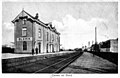
 1920 Het station in Blerick in de Fort St. Michielstraat, Blerick.jpg 1,504 × 961; 353 KB
-

-


_staat_op_de_Nieuwborgstraat_(de_Fort_St._Michielstraat_liep_parallel_aan_het_spoor.jpg)


_-_Fort_St._Michielstraat.jpg)