Category:Flagstone pavements in England
Jump to navigation
Jump to search
Media in category "Flagstone pavements in England"
The following 65 files are in this category, out of 65 total.
-
 Gibberd Garden lily pond Harlow Essex England 06.jpg 6,240 × 4,160; 35.67 MB
-
 Gibberd Garden lily pond Harlow Essex England 07.jpg 4,085 × 6,128; 37.46 MB
-
 At the top of Blakely Clough - geograph.org.uk - 145614.jpg 640 × 480; 87 KB
-
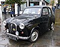 Austin A35 RetroWarwick Classic Car Show Warwickshire UK August 2014.jpg 869 × 688; 490 KB
-
 Bridleway from Marsden - geograph.org.uk - 4367265.jpg 6,000 × 4,000; 5.9 MB
-
 Bridleway from Marsden - geograph.org.uk - 4367291.jpg 6,000 × 4,000; 4.48 MB
-
 Causewayed footpath off Shield Hall Lane - geograph.org.uk - 6825669.jpg 1,024 × 768; 231 KB
-
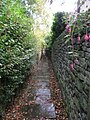
 Disused footpath flagstones, Northowram - geograph.org.uk - 6463446.jpg 2,000 × 1,500; 1.55 MB
-
 Disused gateway and stile on Footpath 9-381, Northowram - geograph.org.uk - 6803801.jpg 2,000 × 1,395; 1.81 MB
-
 Elland FP17 looking towards Lower Edge - geograph.org.uk - 4693023.jpg 2,048 × 1,536; 751 KB
-
 Elland FP17 looking towards Upper Edge - geograph.org.uk - 4692993.jpg 2,048 × 1,536; 729 KB
-
 Elland FP2 crossing a little stream, Greetland - geograph.org.uk - 4490296.jpg 1,460 × 1,992; 1.19 MB
-
 Elland FP2, with a little stream alongside, Greetland - geograph.org.uk - 4490342.jpg 1,536 × 2,048; 741 KB
-
 Flagged Footpath beside Ramsden Wood - geograph.org.uk - 6511375.jpg 5,184 × 3,456; 6.96 MB
-
 Flagged Footpath heading towards Coley Hill - geograph.org.uk - 5891630.jpg 5,184 × 3,456; 2.94 MB
-
 Flagged Footpath heading towards Marsh Farm - geograph.org.uk - 6814320.jpg 5,184 × 3,456; 7.53 MB
-
 Flagged path across a field, Norland - geograph.org.uk - 4881267.jpg 1,992 × 1,464; 1.05 MB
-

-
 Footpath - Bankhouse - geograph.org.uk - 2269680.jpg 480 × 640; 48 KB
-
 Footpath - Bankhouse Bottom to Bankhouse - geograph.org.uk - 2313601.jpg 480 × 640; 117 KB
-
 Footpath - Bankhouse to Bankhouse Bottom - geograph.org.uk - 2313590.jpg 480 × 640; 114 KB
-
 Footpath - Garden Field - geograph.org.uk - 2704750.jpg 480 × 640; 102 KB
-
 Footpath - Keighley Road - geograph.org.uk - 4046607.jpg 640 × 480; 64 KB
-
 Footpath - Rayner Mount - geograph.org.uk - 3197419.jpg 480 × 640; 76 KB
-
 Footpath - School Lane - geograph.org.uk - 3866003.jpg 480 × 640; 101 KB
-
 Footpath 690 approaching Heath Road, Skircoat, Halifax - geograph.org.uk - 5217878.jpg 1,500 × 2,000; 975 KB
-
 Footpath 9-381-2 off Kells Lane, Northowram - geograph.org.uk - 6803502.jpg 2,000 × 1,500; 1.84 MB
-
 Footpath across moorland stream - geograph.org.uk - 3551606.jpg 563 × 750; 143 KB
-
 Footpath approaching Hob Lane, Norland - geograph.org.uk - 4887181.jpg 2,048 × 1,536; 1,013 KB
-

-

-

-
 Footpath to Sowerby Croft, near Hollin Lane, Norland - geograph.org.uk - 4887452.jpg 1,536 × 2,048; 990 KB
-
 Footpath ^ Steps - off Bolton Road - geograph.org.uk - 3943007.jpg 480 × 640; 83 KB
-
 Gate and stile on Sowerby bridge FP77, Norland - geograph.org.uk - 4526278.jpg 2,048 × 1,536; 1.02 MB
-
 Halifax FP324 approaching Fall Lane, Northowram - geograph.org.uk - 5152287.jpg 1,500 × 2,000; 1.07 MB
-
 Halifax FP384 passing Longfield Farm - geograph.org.uk - 5606008.jpg 2,000 × 1,500; 809 KB
-
 Halifax FP384, Northowram - geograph.org.uk - 5606010.jpg 1,500 × 2,000; 982 KB
-
 Improved path on Featherbed Moss - geograph.org.uk - 4519269.jpg 1,600 × 1,200; 650 KB
-

-
 On the footpath from Long Lane to Rochdale Road, Norland - geograph.org.uk - 4883609.jpg 2,048 × 1,536; 1.21 MB
-
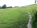
 Path , Broadhead Moss - geograph.org.uk - 4644356.jpg 4,608 × 3,456; 2.66 MB
-
 Path near Broadhead Moss - geograph.org.uk - 6225629.jpg 6,000 × 4,000; 4.24 MB
-
 Path on White Moss - geograph.org.uk - 6224900.jpg 6,000 × 4,000; 6.43 MB
-
 Path on White Moss - geograph.org.uk - 6224908.jpg 6,000 × 4,000; 5.51 MB
-
-
 Paved footpath, Blakeley Clough - geograph.org.uk - 2103805.jpg 2,048 × 1,536; 798 KB
-
 Paved footpath, Blakeley Clough - geograph.org.uk - 2103813.jpg 2,048 × 1,536; 728 KB
-
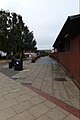 Pavement outside Lightwaves Leisure Centre - geograph.org.uk - 5826120.jpg 2,667 × 4,000; 3 MB
-
 Pavement outside Lightwaves Leisure Centre - geograph.org.uk - 5828423.jpg 4,608 × 3,072; 1.99 MB
-
 Peak and Northern sign at Haigh Gutter - geograph.org.uk - 2738581.jpg 1,600 × 1,200; 578 KB
-
 Queensbury FP27 on an old flagged cart track - geograph.org.uk - 5282781.jpg 2,048 × 1,536; 1,014 KB
-
 Seat on Footpath 9-381-1, Northowram - geograph.org.uk - 6804241.jpg 2,000 × 1,499; 1.64 MB
-
 Sowerby Bridge FP079 (N20) - geograph.org.uk - 4458697.jpg 2,048 × 1,536; 1.04 MB
-
 Stile on Halifax FP384, Northowram - geograph.org.uk - 5606013.jpg 1,500 × 2,000; 904 KB
-
 Stone blocks on Bridleway - geograph.org.uk - 2692186.jpg 1,200 × 1,600; 203 KB
-
 Stone flag surface on Sowerby Bridge FP93, Norland - geograph.org.uk - 4645890.jpg 2,048 × 1,401; 1.06 MB
-
 Stone flags on Halifax FP73, Mixenden - geograph.org.uk - 5452688.jpg 2,000 × 1,500; 1.27 MB
-
 Stone paving on Sowerby Bridge Footpath 78 - geograph.org.uk - 4078072.jpg 2,000 × 1,500; 1.19 MB
-
 The canal alongside the Bethel Street car park, Brighouse - geograph.org.uk - 6714480.jpg 2,000 × 1,463; 1.35 MB
-
 The original route of the Pennine Way - geograph.org.uk - 5573607.jpg 2,000 × 1,500; 855 KB
-
 The original route of the Pennine Way, Marsden - geograph.org.uk - 5573612.jpg 2,000 × 1,476; 810 KB
-
 The original route of the Pennine Way, Marsden - geograph.org.uk - 5573634.jpg 2,000 × 1,500; 1,022 KB
-

-
 View along the Pack Horse Trail to the A640, Marsden Moor - geograph.org.uk - 6481929.jpg 2,000 × 1,331; 3.09 MB


_-_geograph.org.uk_-_4458697.jpg)


