Category:Ex Rifugio Binate
Jump to navigation
Jump to search
|
Ex Rifugio Binate has an entry on OpenStreetMap (show). |
former mountain hut of Lake Como  .jpg) | |||||
| Upload media | |||||
| Instance of |
| ||||
|---|---|---|---|---|---|
| Location | La Via dei Monti Lariani, Lombardy, Italy | ||||
| Mountain range | |||||
| Elevation above sea level |
| ||||
 | |||||
Media in category "Ex Rifugio Binate"
The following 6 files are in this category, out of 6 total.
-
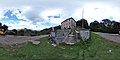 Ex Rifugio Binate (foto panoramica).jpg 5,376 × 2,688; 5.54 MB
-
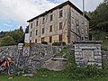 Ex Rifugio Binate.jpg 3,648 × 2,736; 4.36 MB
-
 Ex rifugio Binate.jpg 3,463 × 2,597; 1.82 MB
-
 Rifugio Binate.jpg 3,024 × 4,032; 5.55 MB
-
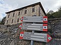 Segnavia presso ex Rifugio Binate.jpg 3,648 × 2,736; 3.55 MB
-
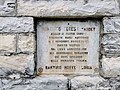 Targa a Domenico Ceresa Tardet.jpg 3,648 × 2,736; 4.06 MB
.jpg)


