Category:English-language maps of Alaska
Jump to navigation
Jump to search
States of the United States: Alabama · Alaska · Arkansas · California · Florida · Louisiana · Maryland · Massachusetts · New Jersey · New Mexico · New York · North Carolina · Ohio · Oklahoma · Pennsylvania · Texas · Utah – Washington, D.C.
Media in category "English-language maps of Alaska"
The following 19 files are in this category, out of 19 total.
-

-

-
 2024 Alaska State House election.svg 820 × 443; 1.38 MB
-
 Alaska - Drawn by John M. Punnett - btv1b53058855v.jpg 8,200 × 6,384; 8.03 MB
-
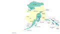
 Alaska boroughs and census areas 2008-13.svg 885 × 500; 278 KB
-
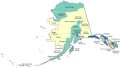
 Alaska boroughs and census areas 2013-19.svg 816 × 461; 334 KB
-
 Alaska boroughs and census areas 2019.svg 2,563 × 1,344; 1.57 MB
-
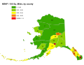
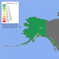 Alaska population map.png 600 × 600; 97 KB
-
 Alaska regions map.png 3,008 × 1,697; 1.46 MB
-
 Alaska regions map.svg 2,972 × 1,677; 1.79 MB
-
 Alaska. - Map of Alaska, by the Alaska road commission - btv1b53209784m.jpg 21,818 × 18,714; 65.22 MB
-

-
 Carte de l'Alaska - btv1b531213191.jpg 8,828 × 6,832; 7 MB
-
 Department of the Interior. U. S. geological Survey. Map of Alaska... - btv1b8458656c.jpg 10,614 × 7,798; 11.25 MB
-
 Department of the Interior. U. S. geological Survey. Map of Alaska... - btv1b84589305.jpg 10,638 × 7,906; 11.75 MB
-
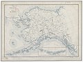
 Map of Alaska and adjoining regions. LOC 99446186.jpg 2,828 × 2,322; 1.08 MB
-
 NRHP Alaska Map.svg 792 × 612; 249 KB
-

-


.jpg)