Category:East Suffolk Line
Jump to navigation
Jump to search
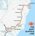
English: The East Suffolk Line is an un-electrified secondary railway line running between Ipswich and Lowestoft in Suffolk, England.
railway line in the UK | |||||
| Upload media | |||||
| Instance of |
| ||||
|---|---|---|---|---|---|
| Part of |
| ||||
| Location | Suffolk, East of England, England | ||||
| Owned by | |||||
| Operator |
| ||||
| Date of official opening |
| ||||
| Length |
| ||||
| Terminus |
| ||||
| |||||
Subcategories
This category has the following 19 subcategories, out of 19 total.
B
- Bealings railway station (12 F)
- Beccles railway station (61 F)
- Boss Hall Junction (3 F)
D
- Darsham railway station (33 F)
E
- East Suffolk Junction (14 F)
- ELR:ESK (16 F)
- Europa Junction (5 F)
H
I
L
M
- Melton railway station (16 F)
O
- Oulton Broad Swingbridge (14 F)
S
- Saxmundham railway station (46 F)
W
- Woodbridge railway station (41 F)
Media in category "East Suffolk Line"
The following 33 files are in this category, out of 33 total.
-
Along the Tracks to Bigsby's Corner and Benhall - geograph.org.uk - 1457667.jpg 3,072 × 2,304; 1.38 MB
-
Along the Tracks to Saxmundham - geograph.org.uk - 1457665.jpg 3,072 × 2,304; 1.52 MB
-
Driver's view towards Beccles - geograph.org.uk - 978215.jpg 640 × 477; 115 KB
-
Driver's view towards Brampton - geograph.org.uk - 397892.jpg 640 × 477; 129 KB
-
East Suffolk Line - geograph.org.uk - 1735668.jpg 2,304 × 3,072; 2.65 MB
-
East Suffolk Line - geograph.org.uk - 1735676.jpg 2,304 × 3,072; 2.95 MB
-
East Suffolk Line around Woodbridge - 19613462584.jpg 4,502 × 2,702; 1.96 MB
-
East Suffolk Line around Woodbridge - 20048208488.jpg 5,034 × 2,871; 1.51 MB
-
East Suffolk Line around Woodbridge - 20227949932.jpg 4,845 × 3,123; 1.59 MB
-
East Suffolk Line around Woodbridge - 20236151655.jpg 2,908 × 3,484; 1.67 MB
-
East Suffolk Line around Woodbridge - 20236185335.jpg 5,391 × 2,745; 1.71 MB
-
East Suffolk Line around Woodbridge - 20236194375.jpg 5,013 × 3,277; 1.89 MB
-
East Suffolk Line around Woodbridge - 20241917811.jpg 2,809 × 3,281; 791 KB
-
East Suffolk Line around Woodbridge - 20241933021.jpg 3,556 × 3,817; 1.61 MB
-
East Suffolk Line around Woodbridge - 20241969321.jpg 4,992 × 2,703; 2.22 MB
-
East Suffolk Line around Woodbridge - 20242001601.jpg 4,817 × 3,375; 1.86 MB
-
East Suffolk Line around Woodbridge.jpg 4,572 × 3,060; 1.36 MB
-
East Suffolk line.png 1,575 × 1,615; 1.33 MB
-
East Suffolk Railway from the Henley Road overbridge - geograph.org.uk - 6613120.jpg 6,000 × 4,000; 6.66 MB
-
Ipswich station - National Express 156422 with East Suffolk Line branding.jpg 1,824 × 1,368; 715 KB
-
Memories of 1987 (16894913350).jpg 1,884 × 1,260; 1.26 MB
-
NXEAtrain.JPG 3,264 × 2,448; 1.51 MB
-
Railway line heading north from Saxmundham - geograph.org.uk - 6294970.jpg 1,600 × 1,064; 343 KB
-
Riverside path, Woodbridge - geograph.org.uk - 1299836.jpg 640 × 480; 60 KB
-
B1121 Main Road, Saxmundham - geograph.org.uk - 1242847.jpg 3,072 × 2,304; 1.4 MB
-
Bridge over the Railway - geograph.org.uk - 1457664.jpg 3,072 × 2,304; 1.47 MB
-
Railway north of Saxmundham - geograph.org.uk - 177734.jpg 640 × 480; 120 KB
-
The Aldeburgh branch - geograph.org.uk - 1317692.jpg 640 × 480; 74 KB
-
Saxmundham Junction looking south.jpg 768 × 916; 259 KB
-
Tamping machine on the newly installed Beccles Loop (1) - geograph.org.uk - 2942236.jpg 3,479 × 2,319; 3.3 MB
-
View along railway track - geograph.org.uk - 542712.jpg 426 × 640; 129 KB


