Category:Dwyriw
Jump to navigation
Jump to search
community in Powys, mid Wales  | |||||
| Upload media | |||||
| Pronunciation audio | |||||
|---|---|---|---|---|---|
| Instance of | |||||
| Location | Powys, Wales | ||||
| Population |
| ||||
| Area |
| ||||
 | |||||
Subcategories
This category has the following 4 subcategories, out of 4 total.
Media in category "Dwyriw"
The following 135 files are in this category, out of 135 total.
-

-
 A bare field near Ty-newydd - geograph.org.uk - 5805892.jpg 1,024 × 680; 296 KB
-
 A field of buttercups - geograph.org.uk - 5805940.jpg 1,024 × 680; 325 KB
-

-
 A Ty Bach - geograph.org.uk - 3009858.jpg 2,560 × 1,920; 1.14 MB
-
 Afon Rhiw - geograph.org.uk - 3009404.jpg 2,560 × 1,920; 1.11 MB
-

-

-

-

-
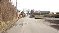
 B4389 heading north past a new unmapped building - geograph.org.uk - 5019018.jpg 1,024 × 768; 112 KB
-
 B4389 heading south towards Birch House - geograph.org.uk - 5020753.jpg 1,024 × 768; 109 KB
-
 Barn near Nant y Llyn Mawr - geograph.org.uk - 3683746.jpg 1,024 × 680; 233 KB
-
 Barns at Ty Coch, Llanwyddelan - geograph.org.uk - 5020827.jpg 1,024 × 768; 138 KB
-

-
 Bends at Pont Ystrad - geograph.org.uk - 3355046.jpg 640 × 378; 67 KB
-
 Beudyhir from Bryn Newydd - geograph.org.uk - 3355018.jpg 640 × 448; 110 KB
-
 Building on Mynydd Clogau Windfarm - geograph.org.uk - 3684654.jpg 1,024 × 680; 191 KB
-
 Cattle in a field - geograph.org.uk - 5805919.jpg 1,024 × 680; 255 KB
-
 Cefn Coch centre - geograph.org.uk - 3355023.jpg 640 × 357; 62 KB
-
 Cefn Coch from the west - geograph.org.uk - 3355020.jpg 640 × 502; 102 KB
-
 Churchyard retaining wall, St Mary's, Llanllugan - geograph.org.uk - 5020894.jpg 1,024 × 768; 155 KB
-
 Country lane near Sychnant - geograph.org.uk - 900015.jpg 640 × 480; 94 KB
-
 Country road near Ty-newydd - geograph.org.uk - 5805879.jpg 1,024 × 680; 239 KB
-
 Cow parsley in a roadside verge - geograph.org.uk - 5806043.jpg 1,024 × 680; 356 KB
-
 Crocuses beside the River Rhiw - geograph.org.uk - 3341641.jpg 480 × 640; 183 KB
-

-
 Cwm Llanllugan Community Centre - geograph.org.uk - 3009872.jpg 2,560 × 1,920; 1.15 MB
-
 Dilapidated wooden building at Bryngair - geograph.org.uk - 1219325.jpg 640 × 480; 212 KB
-
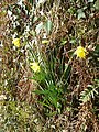 Early daffs beside the River Rhiw - geograph.org.uk - 3341630.jpg 480 × 640; 211 KB
-
 Early daffs beside the River Rhiw - geograph.org.uk - 3341634.jpg 480 × 640; 192 KB
-
 Early daffs beside the River Rhiw - geograph.org.uk - 3341635.jpg 640 × 640; 259 KB
-
 Entrance to Bowen's Tan-y-Foel Quarry - geograph.org.uk - 899978.jpg 640 × 480; 64 KB
-
 Entrance to Gwaun-y-Maglau - geograph.org.uk - 3354619.jpg 640 × 444; 57 KB
-
 Esgair Cwmowen - geograph.org.uk - 1886529.jpg 640 × 480; 83 KB
-
 Farm machinery and upland track - geograph.org.uk - 3682596.jpg 1,024 × 680; 195 KB
-
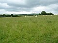
 Farmland in the Rhiw valley - geograph.org.uk - 5806057.jpg 1,024 × 680; 292 KB
-
 Farmland in the valley of Dolgar Brook - geograph.org.uk - 5020741.jpg 1,024 × 768; 120 KB
-
 Farmland near Sychnant - geograph.org.uk - 5805084.jpg 1,024 × 680; 229 KB
-
 Farmland near Ty-newydd - geograph.org.uk - 5805864.jpg 1,024 × 680; 270 KB
-
 Farmland on the north side of Llanllugan - geograph.org.uk - 5020863.jpg 1,024 × 768; 159 KB
-
 Farmland on the west side of the B4389 - geograph.org.uk - 5020746.jpg 1,024 × 768; 117 KB
-

-
 Field headland track - geograph.org.uk - 5805949.jpg 1,024 × 680; 286 KB
-
 Field near Glan-yr-afon - geograph.org.uk - 5805801.jpg 1,024 × 680; 245 KB
-
 Field of buttercups - geograph.org.uk - 5805943.jpg 1,024 × 680; 299 KB
-
 Footbridge over Afon Rhiw - geograph.org.uk - 3009423.jpg 2,560 × 1,920; 1.11 MB
-
 Footpath across the Rhiw - geograph.org.uk - 2192912.jpg 640 × 480; 82 KB
-
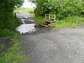
 Ford across the Rhiw near Llanllugan - geograph.org.uk - 2192890.jpg 640 × 480; 94 KB
-
 Ford across the Rhiw near Llanllugan - geograph.org.uk - 3341591.jpg 640 × 480; 146 KB
-
 Ford across the Rhiw near Llanllugan - geograph.org.uk - 3341648.jpg 640 × 480; 152 KB
-
 Ford and Footbridge near Plas y Drain - geograph.org.uk - 3009856.jpg 2,560 × 1,920; 1.08 MB
-
 Ford and waterfall on the River Rhiw - geograph.org.uk - 3341613.jpg 640 × 480; 145 KB
-
 Ford near Lluast - geograph.org.uk - 3019088.jpg 2,560 × 1,920; 1.11 MB
-
 Ford on the Rhiw - geograph.org.uk - 2192883.jpg 640 × 480; 97 KB
-
 Ford on un-marked track - geograph.org.uk - 1808143.jpg 640 × 480; 84 KB
-
 Gate on Mynydd Cerrigllwydion - geograph.org.uk - 3683752.jpg 1,024 × 680; 244 KB
-
 Golden fields, Llanllugan - geograph.org.uk - 5020903.jpg 1,024 × 768; 152 KB
-
 Gors-dyfwch - geograph.org.uk - 899332.jpg 640 × 480; 69 KB
-
 Grassland beside Mynydd Clogau windfarm - geograph.org.uk - 3684726.jpg 1,024 × 680; 288 KB
-
 Grazing sheep, north of Adfa - geograph.org.uk - 5020851.jpg 1,024 × 768; 143 KB
-
 Interior of Llanllugan church - geograph.org.uk - 5805976.jpg 1,024 × 680; 166 KB
-
 Junction of Tracks neaer Lluast - geograph.org.uk - 3009845.jpg 2,560 × 1,920; 1.16 MB
-
 Llanwyddelan church from the south - geograph.org.uk - 5020821.jpg 1,024 × 768; 167 KB
-
 Llawnt Ucha Farm - geograph.org.uk - 900143.jpg 640 × 480; 66 KB
-
 Lluast - geograph.org.uk - 900001.jpg 640 × 480; 70 KB
-
 Meadow, north of Adfa - geograph.org.uk - 5020843.jpg 1,024 × 768; 129 KB
-
 Moorland track - geograph.org.uk - 1884564.jpg 640 × 480; 86 KB
-
 Mynydd Cerrigllwydion - geograph.org.uk - 1435804.jpg 640 × 480; 44 KB
-
 Mynydd Clogau Windfarm - geograph.org.uk - 2581647.jpg 940 × 595; 67 KB
-
 Mynydd Glogau windfarm - geograph.org.uk - 3683758.jpg 1,024 × 680; 161 KB
-
 Mynydd Glogau windfarm - geograph.org.uk - 3683760.jpg 1,024 × 680; 154 KB
-
 New drain - geograph.org.uk - 1884576.jpg 640 × 480; 88 KB
-
 New woodland - geograph.org.uk - 1884606.jpg 640 × 480; 88 KB
-
 Path down from the churchyard, Llanllugan - geograph.org.uk - 5020865.jpg 1,024 × 768; 194 KB
-
 Pen-y-ffridd - geograph.org.uk - 5805886.jpg 1,024 × 680; 279 KB
-
 Phone box at Ty-Bach road junction - geograph.org.uk - 3354637.jpg 640 × 399; 63 KB
-
 Pistyll-du farmhouse - geograph.org.uk - 1884442.jpg 640 × 480; 90 KB
-
 Ploughed field in the Rhiw valley - geograph.org.uk - 5805899.jpg 1,024 × 680; 254 KB
-
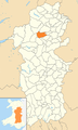 Powys Wales communities - Dwyriw locator.png 780 × 1,300; 425 KB
-
 Quarried sandstone outcrop - geograph.org.uk - 1884414.jpg 640 × 480; 97 KB
-
 Quarrying work - geograph.org.uk - 3682612.jpg 1,024 × 680; 208 KB
-
 Rhiw valley - geograph.org.uk - 5805947.jpg 1,024 × 680; 292 KB
-
 River Rhiw above the ford - geograph.org.uk - 2192902.jpg 640 × 480; 107 KB
-
 River Rhiw below the ford - geograph.org.uk - 2192896.jpg 640 × 480; 108 KB
-
 River Rhiw below the ford - geograph.org.uk - 3341604.jpg 640 × 480; 167 KB
-
 River Rhiw below the ford and waterfall - geograph.org.uk - 3341623.jpg 640 × 480; 191 KB
-
 River Rhiw in snow-melt flood - geograph.org.uk - 2192908.jpg 640 × 480; 130 KB
-
 Road Junction with Phone Box - geograph.org.uk - 2985852.jpg 3,943 × 2,889; 2.83 MB
-
 Road passing Mynydd yr Hendre - geograph.org.uk - 3354570.jpg 640 × 438; 47 KB
-
 Road passing Tan-y-Foel Quarry - geograph.org.uk - 5804917.jpg 1,024 × 680; 221 KB
-
 Road to Adfa - geograph.org.uk - 5805906.jpg 1,024 × 680; 246 KB
-
 Rough grazing near Bryngwyn - geograph.org.uk - 899962.jpg 640 × 480; 65 KB
-
 Ruined sheepfold - geograph.org.uk - 1884401.jpg 640 × 480; 96 KB
-
 Sheep by Newmills Bridge - geograph.org.uk - 3341569.jpg 640 × 480; 137 KB
-
 Sheep grazing, Llanwyddelan - geograph.org.uk - 5020830.jpg 1,024 × 768; 139 KB
-
 Sheep pasture in the valley of Dolgar Brook - geograph.org.uk - 5020770.jpg 1,024 × 615; 103 KB
-
 Sheep pasture, Llanwyddelan - geograph.org.uk - 5020835.jpg 1,024 × 768; 141 KB
-
 Small ford near Frongoch Hall - geograph.org.uk - 3009317.jpg 2,560 × 1,920; 1.15 MB
-
 Small quarry - geograph.org.uk - 1886489.jpg 640 × 480; 87 KB
-
 South-eastern corner, St Mary's churchyard - geograph.org.uk - 5020898.jpg 1,024 × 768; 165 KB
-
 Spring display near Ty'n-y-shettin - geograph.org.uk - 1212484.jpg 640 × 481; 233 KB
-
 Stone circle - geograph.org.uk - 1884476.jpg 640 × 480; 99 KB
-

-
 Stream gully - geograph.org.uk - 1886467.jpg 640 × 480; 97 KB
-
 Sweet spot - geograph.org.uk - 1884529.jpg 640 × 480; 99 KB
-

-
 Tan-y-Foel Quarry - geograph.org.uk - 5804902.jpg 1,024 × 680; 219 KB
-
 Tan-y-Foel Quarry - geograph.org.uk - 899339.jpg 640 × 480; 60 KB
-
 The road from Llanllugan to Adfa - geograph.org.uk - 5020855.jpg 1,024 × 768; 166 KB
-
 The upper Rhiw valley - geograph.org.uk - 5805903.jpg 1,024 × 680; 212 KB
-
 Towards Bryn Coch - geograph.org.uk - 1567619.jpg 640 × 427; 201 KB
-
 Track across upland grazing - geograph.org.uk - 3682600.jpg 1,024 × 680; 209 KB
-
 Track between Lluast and Plas y Drain - geograph.org.uk - 3009852.jpg 2,560 × 1,920; 1.16 MB
-
 Track down from Mynydd Clogau - geograph.org.uk - 1433435.jpg 640 × 480; 69 KB
-
 Track onto field behind Frongoch Hall - geograph.org.uk - 3009307.jpg 2,560 × 1,920; 1.15 MB
-
 Track to Cytir - geograph.org.uk - 5805936.jpg 1,024 × 680; 305 KB
-
 Track up Mynydd Clogau - geograph.org.uk - 1433426.jpg 640 × 480; 51 KB
-
 Track-side waterfall - geograph.org.uk - 1884427.jpg 640 × 480; 93 KB
-
 Tree in a field - geograph.org.uk - 5805924.jpg 680 × 1,024; 292 KB
-
 Un-named ruin - geograph.org.uk - 1884594.jpg 640 × 480; 88 KB
-
 Upland track near Waun y Llyn - geograph.org.uk - 3683743.jpg 1,024 × 680; 231 KB
-
 Valley of the Afon Rhiw - geograph.org.uk - 900024.jpg 640 × 480; 65 KB
-
 View north-west from Mynydd Cerrigllwydion - geograph.org.uk - 3683753.jpg 1,024 × 680; 209 KB
-
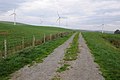
 View to a wind farm - geograph.org.uk - 5805075.jpg 1,024 × 680; 203 KB
-
 View to Llanllugan church - geograph.org.uk - 5806036.jpg 1,024 × 680; 296 KB
-
 View to Mynydd Dwyriw - geograph.org.uk - 5804891.jpg 1,024 × 680; 210 KB
-
 View to Ty-newydd - geograph.org.uk - 5805099.jpg 1,024 × 680; 264 KB
-
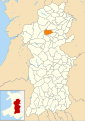 Wales Powys Community Dwyriw map.svg 512 × 723; 1.15 MB
-
 Wall and stream - geograph.org.uk - 1808141.jpg 640 × 480; 92 KB
-
 Waterfall on the Rhiw near Llanllugan - geograph.org.uk - 3341654.jpg 640 × 480; 140 KB
-
 Waun y Llyn - geograph.org.uk - 3684590.jpg 640 × 425; 167 KB
-
 Wind turbine on Mynydd Glogau windfarm - geograph.org.uk - 3683761.jpg 1,024 × 680; 125 KB
-
 Wind turbines on Mynydd Rhos-fach - geograph.org.uk - 5804835.jpg 1,024 × 680; 208 KB
-
 Ye Olde Petrol Station - geograph.org.uk - 3009879.jpg 1,920 × 2,560; 1.1 MB


