Category:Dorfkirche Hermersdorf
Jump to navigation
Jump to search
| Object location | | View all coordinates using: OpenStreetMap |
|---|
church building in Brandenburg state, Germany  | |||||
| Upload media | |||||
| Instance of | |||||
|---|---|---|---|---|---|
| Location | Q123914151, Müncheberg, Märkisch-Oderland District, Brandenburg, Germany | ||||
| Heritage designation | |||||
 | |||||
This is the category of the Brandenburger Baudenkmal (cultural heritage monument) with the ID 09180471 (Wikidata)
|
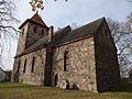
English: Pictures of the church in Hermersdorf , Müncheberg municipality, Märkisch-Oderland district, Brandenburg state, Germany
Deutsch: Bilder der Kirche in Hermersdorf , Gemeinde Müncheberg, Landkreis Märkisch-Oderland, Land Brandenburg, Deutschland.
Français : Photos de l'église à Hermersdorf , commune de Müncheberg, arrondissement de Märkisch-Oderland, état fédéral de Brandebourg, Allemagne
Media in category "Dorfkirche Hermersdorf"
The following 17 files are in this category, out of 17 total.
-
 Dorfkirche Hermersdorf Chor Nordansicht.jpg 4,608 × 3,456; 5.69 MB
-
 Dorfkirche Hermersdorf Chor Südansicht Denkmal WK I.jpg 4,608 × 3,456; 6.83 MB
-
 Dorfkirche Hermersdorf Chor Südansicht.jpg 4,608 × 3,456; 5.9 MB
-
 Dorfkirche Hermersdorf Kirchenschiff Nordansicht.jpg 4,608 × 3,456; 6.33 MB
-
 Dorfkirche Hermersdorf Kirchenschiff Südansicht.jpg 4,608 × 3,456; 6.45 MB
-
 Dorfkirche Hermersdorf Nordostansicht.jpg 4,608 × 3,456; 5.11 MB
-
 Dorfkirche Hermersdorf Ostansicht.jpg 3,456 × 4,608; 5.15 MB
-
 Dorfkirche Hermersdorf Südostansicht II.jpg 4,608 × 3,456; 6.53 MB
-
 Dorfkirche Hermersdorf Südostansicht.jpg 4,608 × 3,456; 6.1 MB
-
 Dorfkirche Hermersdorf Westportal.jpg 4,608 × 3,456; 5.89 MB
-
 Dorfkirche Hermersdorf Westturm Nordansicht.jpg 3,456 × 4,608; 4.8 MB
-
 Dorfkirche Hermersdorf Westturm Südansicht.jpg 3,456 × 4,608; 5.49 MB
-
 Dorfkirche Hermersdorf Westturm Südwestansicht.jpg 3,456 × 4,608; 5.16 MB
-
 Dorfkirche Hermersdorf Westturm Westansicht.jpg 3,456 × 4,608; 4.94 MB
-
 Hermersdorf Dorfkirche.JPG 3,648 × 2,736; 2.18 MB
-
 Hermersdorf Kirche Chor Müncheberg.jpg 6,016 × 4,000; 4.79 MB
-
 Hermersdorf Kirche Südseite Müncheberg.jpg 6,016 × 4,000; 4.23 MB


