Category:Dobson, New Zealand
Jump to navigation
Jump to search
locality in Grey District, West Coast Region, New Zealand  | |||||
| Upload media | |||||
| Instance of | |||||
|---|---|---|---|---|---|
| Named after | |||||
| Location | Grey District, West Coast Region, New Zealand | ||||
| Population |
| ||||
 | |||||
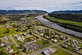
English: Dobson is a small town on the banks of the Grey River in the South Island of New Zealand. It is 10 kilometres east from the river's mouth at Greymouth. The settlement of Taylorville is across the river from Dobson, but no bridge directly connects the two. State Highway 7 passes through Dobson.
Media in category "Dobson, New Zealand"
The following 16 files are in this category, out of 16 total.
-
 Blackball from ngahere in april 2009 - panoramio.jpg 600 × 450; 25 KB
-
 Dobson • Jase Blair • MRD 1.jpg 2,400 × 1,599; 1.51 MB
-
 Dobson • Jase Blair • MRD 2.jpg 2,400 × 1,599; 1.55 MB
-
 Dobson • Jase Blair • MRD 3.jpg 2,400 × 1,599; 1.56 MB
-
 Dobson • Jase Blair • MRD 4.jpg 2,400 × 1,600; 1.44 MB
-
 Dobson, New Zealand.jpg 3,872 × 2,592; 3.5 MB
-
 Dobson-Brunnerton Heritage Park MRD.jpg 4,032 × 3,024; 5.81 MB
-
 Feeling a little saggy - panoramio.jpg 2,810 × 1,872; 1.32 MB
-
 Giovanni (Jan) Soster stands beside his 1946 Ford Coupe, Dobson, 1987. CC146.jpg 2,057 × 1,465; 1.88 MB
-
 Greymouth 1 (31589270641).jpg 5,022 × 2,945; 9.27 MB
-

-
 Old gold mining machinery - panoramio.jpg 2,770 × 1,808; 1.23 MB
-
 Seen from the Train 1 (31558417652).jpg 4,661 × 2,343; 7.9 MB
-
 Tailrace stream, Nelson Creek - panoramio.jpg 1,880 × 2,816; 2.54 MB
-

-
 Waiting for the train - panoramio - DB Thats-Me.jpg 1,880 × 2,816; 1.38 MB


_Soster_stands_beside_his_1946_Ford_Coupe,_Dobson,_1987._CC146.jpg)
.jpg)
.jpg)

.jpg)


