Category:Diagrams of water transport signs
Jump to navigation
Jump to search
Subcategories
This category has the following 4 subcategories, out of 4 total.
Media in category "Diagrams of water transport signs"
The following 117 files are in this category, out of 117 total.
-
Abzweigung Grün-Rot.svg 289 × 177; 10 KB
-
Abzweigung Rot-Grün.svg 451 × 177; 12 KB
-
Ankarboj, Nordisk familjebok.png 268 × 910; 12 KB
-
ATON - Road Signs of the Waterway.png 419 × 256; 16 KB
-
B.16 Kennzeichnung besonderer Gefahrenstellen.svg 495 × 199; 17 KB
-
Bell and gong buoy near Norfolk Virginia on OpenSeaMap.png 427 × 437; 28 KB
-
Bell buoys near Ramsgate on OpenSeaMap.png 360 × 363; 9 KB
-
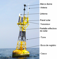
BoyaPartes.PNG 517 × 540; 367 KB
-
Buoys.svg 750 × 516; 128 KB
-
Cardinal E Q.gif 50 × 50; 1 KB
-
Cardinal mark diagram.svg 1,000 × 1,000; 83 KB
-
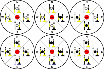
Cardinal marks at night.gif 190 × 185; 40 KB
-
Cardinal Marks.gif 300 × 300; 40 KB
-
Cardinal N Q.gif 50 × 50; 460 bytes
-
Cardinal S Q.gif 50 × 50; 2 KB
-
Cardinal W Q.gif 50 × 50; 3 KB
-
Cardinales.png 312 × 465; 13 KB
-
CardinalMarks.png 1,024 × 1,030; 92 KB
-
Danger-isole.png 138 × 138; 4 KB
-
Einzelgefahrenzeichen.svg 408 × 221; 13 KB
-
Epave urgence.png 153 × 256; 21 KB
-
Epave urgence.svg 350 × 704; 5 KB
-
Extremity light of plateform - (Mo(U)) R 15s.gif 100 × 100; 5 KB
-
Fahrwasser Grün.svg 355 × 177; 13 KB
-
Fahrwasser Mitte.svg 387 × 177; 10 KB
-
Fahrwasser Rot.svg 585 × 177; 26 KB
-
Fahrwasserzeichen.png 767 × 1,067; 54 KB
-
Fix.gif 50 × 50; 581 bytes
-
IALA B red turn mark.png 231 × 141; 42 KB
-
IALA east cardinal mark.png 156 × 150; 8 KB
-
IALA green mark.png 219 × 141; 9 KB
-
IALA green turn mark B.png 219 × 141; 41 KB
-
IALA green turn mark.png 231 × 141; 10 KB
-
IALA isolated danger.png 156 × 149; 8 KB
-
IALA Maritime Buoyage System Regions.svg 2,754 × 1,398; 1.21 MB
-
IALA north cardinal mark.png 156 × 148; 7 KB
-
IALA red mark.png 219 × 139; 7 KB
-
IALA red turn mark.png 219 × 141; 10 KB
-
IALA safe water.png 219 × 135; 14 KB
-
IALA south cardinal mark.png 156 × 150; 7 KB
-
IALA specjal mark.png 219 × 139; 11 KB
-
IALA west cardinal mark.png 156 × 151; 8 KB
-
IALA world distribution.PNG 947 × 505; 94 KB
-
Int W.gif 50 × 50; 3 KB
-
Iso.gif 50 × 50; 3 KB
-
Isolated danger mark.PNG 255 × 141; 2 KB
-
Kardinalzeichen Nord.svg 408 × 221; 15 KB
-
Kardinalzeichen Ost.svg 408 × 221; 12 KB
-
Kardinalzeichen Süd.svg 408 × 221; 15 KB
-
Kardinalzeichen West.svg 408 × 221; 11 KB
-
Kennzeichnung von Gefahrenstellen.png 767 × 1,067; 46 KB
-
KRW.png 80 × 100; 331 bytes
-
Lam W2.gif 50 × 50; 3 KB
-
Lam Y.gif 50 × 50; 3 KB
-
Lam.gif 50 × 50; 3 KB
-
Lateral buoy g.gif 120 × 130; 29 KB
-
Lateral buoy g.svg 188 × 188; 11 KB
-
Lateral buoy r.gif 120 × 125; 25 KB
-
Lateral buoy r.svg 188 × 188; 11 KB
-
Lateral system a mark.PNG 512 × 103; 4 KB
-
Lateral system a mark.svg 372 × 59; 3 KB
-
Lateral system b mark.PNG 512 × 103; 3 KB
-
Lateral system b mark.svg 384 × 77; 2 KB
-
Light of East cardinal mark - (Q(3)) W 10s.gif 100 × 100; 5 KB
-
Light of East cardinal mark - (VQ(3)) W 5s.gif 100 × 100; 5 KB
-
Light of isolated danger mark - (Fl(2)) W 10s.gif 100 × 100; 4 KB
-
Light of isolated danger mark - (Fl(2)) W 5s.gif 100 × 100; 4 KB
-
Light of New danger mark - (Al Oc) BY 3s.gif 100 × 100; 4 KB
-
Light of North cardinal mark - (Q) W 1s - (0.7 ; 0.3).gif 100 × 100; 2 KB
-
Light of North cardinal mark - (VQ) W 0.5s.gif 100 × 100; 2 KB
-
Light of safe water mark - (Iso) W 2s.gif 100 × 100; 2 KB
-
Light of safe water mark - (LFl) W 10s.gif 100 × 100; 2 KB
-
Light of safe water mark - (Mo(A)) W 6s.gif 100 × 100; 4 KB
-
Light of safe water mark - (Oc) W 2s.gif 100 × 100; 2 KB
-
Light of South cardinal mark - (Q(6)+LFI) W 15s.gif 100 × 100; 12 KB
-
Light of South cardinal mark - (VQ(6)+LFI)W10s.gif 100 × 100; 12 KB
-
Light of special mark - (Fl) Y 4s (Canadian standard).gif 100 × 100; 2 KB
-
Light of West cardinal mark - (Q(9)) W 15s.gif 100 × 100; 16 KB
-
Light of West cardinal mark - (VQ(9)) W 10s.gif 100 × 100; 16 KB
-
Main light of plateform - (Mo(U)) W 15s.gif 100 × 100; 5 KB
-
Map IALA regions.png 1,425 × 625; 41 KB
-
Nordremmare.png 15 × 185; 261 bytes
-
Notice A.1. No entry.svg 360 × 300; 364 bytes
-
Notice A.20 Water bikes prohibited.svg 300 × 300; 1 KB
-
Notice A.5. No berthing.svg 300 × 300; 663 bytes
-
Notice A.5.1. No berthing lateral limit.svg 300 × 300; 666 bytes
-
Notice A.8. No turning.svg 300 × 300; 762 bytes
-
Notice E.1. Entry permitted.svg 360 × 300; 368 bytes
-
Notice E.15. Motorized vessels permitted.svg 300 × 300; 892 bytes
-
Notice E.24 Water bikes permitted.svg 300 × 300; 1 KB
-
Notice E.5. Berthing permitted.svg 300 × 300; 505 bytes
-
Notice E.5.1. Berthing lateral limit.svg 300 × 300; 508 bytes
-
Notice E.5.2. Berthing lateral limits.svg 600 × 300; 511 bytes
-
Notice E.5.3. Berth rafting limit.svg 300 × 300; 509 bytes
-
Notice E.8. Turning area.svg 300 × 300; 629 bytes
-
Nuevos peligros.png 441 × 245; 10 KB
-
Ostremmare.png 16 × 185; 272 bytes
-
Safe water mark.PNG 446 × 178; 4 KB
-
Schema Gierfähre.png 767 × 1,067; 33 KB
-
Schema Gierfähre.svg 512 × 585; 59 KB
-
Special mark.PNG 233 × 108; 2 KB
-
Sydremmare.png 16 × 187; 260 bytes
-
USCG Daymarks.png 500 × 500; 22 KB
-
VANG-isolated danger.svg 500 × 1,460; 5 KB
-
VANG-lateral A PS.svg 500 × 1,460; 6 KB
-
VANG-lateral A StB.svg 500 × 1,460; 6 KB
-
VANG-lateral B PS.svg 500 × 1,460; 7 KB
-
VANG-lateral B StB.svg 500 × 1,460; 7 KB
-
VANG-safe water.svg 500 × 1,460; 6 KB
-
Visual Aid to Navigation Guide - Region B - Day.svg 542 × 361; 110 KB
-
Visual Aid to Navigation Guide - Region B - Night.svg 542 × 363; 102 KB
-
Västremmare.png 15 × 185; 272 bytes


