Category:Dam in Międzygórze
Jump to navigation
Jump to search
| Object location | | View all coordinates using: OpenStreetMap |
|---|
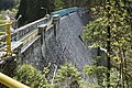
dam impounding the river Wilczka near Międzygórze, Poland  | |||||
| Upload media | |||||
| Instance of | |||||
|---|---|---|---|---|---|
| Location | Międzygórze, Gmina Bystrzyca Kłodzka, Kłodzko County, Lower Silesian Voivodeship, Poland | ||||
| Located in or next to body of water | |||||
| Significant event |
| ||||
 | |||||
Media in category "Dam in Międzygórze"
The following 7 files are in this category, out of 7 total.
-
 2016 Zapora w Międzygórzu 1.jpg 4,059 × 2,898; 10.85 MB
-
 2016 Zapora w Międzygórzu 2.jpg 4,264 × 3,104; 12.85 MB
-
 2016 Zapora w Międzygórzu 3.jpg 4,186 × 2,796; 11.11 MB
-
 2016 Zapora w Międzygórzu 4.jpg 4,108 × 2,988; 12.54 MB
-
 2016 Zapora w Międzygórzu 5.jpg 4,470 × 2,922; 12.84 MB
-
 Międzygórze17.jpg 778 × 583; 183 KB
-
 Water Dam of Międzygórze.jpg 6,000 × 4,000; 7.82 MB


