Category:Crows-an-Wra
Jump to navigation
Jump to search
hamlet in Cornwall, England, UK | |||||
| Upload media | |||||
| Instance of | |||||
|---|---|---|---|---|---|
| Location | St Buryan, Lamorna and Paul, Cornwall, South West England, England | ||||
| Elevation above sea level |
| ||||
 | |||||
Deutsch: Crows-an-Wra ( kornisch: Krows an Wragh, "Kreuzung der Hexe") ist ein Weiler der Pfarrgemeinde St Buryan in der Grafschaft Cornwall in England.
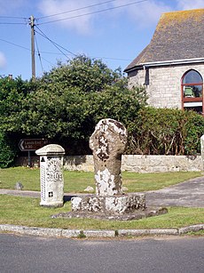
English: The hamlet consists of a main cluster of dwellings about 5 miles (8 km) along the A30 from Penzance, as well as some others more distant including those at Boscarne. The name Crows-an-Wra translates from the Cornish as "witches crossing" and there is evidence that the site was important in neolithic times, including a nearby celtic cross and a holy well. The hamlet once had its own methodist chapel, but this has since fallen into disuse and has subsequently been converted into housing.
Media in category "Crows-an-Wra"
The following 35 files are in this category, out of 35 total.
-
A corner of Land's End Aerodrome - geograph.org.uk - 1080600.jpg 640 × 427; 64 KB
-
A30, next stop Penzance - geograph.org.uk - 912180.jpg 640 × 480; 226 KB
-
Ancient cross at Crows-An-Wra - geograph.org.uk - 801125.jpg 480 × 640; 103 KB
-
Bolankan House - geograph.org.uk - 2399303.jpg 640 × 480; 83 KB
-
Bosanketh Farm - geograph.org.uk - 1583575.jpg 640 × 480; 89 KB
-
Cairn on Tredinney Common - geograph.org.uk - 3288504.jpg 1,142 × 857; 285 KB
-
Crows-an-Wra Milestone. - panoramio.jpg 2,248 × 4,000; 5.15 MB
-
CrowsanWra.jpg 1,920 × 2,560; 712 KB
-
CrowsanWraCelticcross.jpg 1,920 × 2,560; 549 KB
-
Dilapidated barn at Crella Farm - geograph.org.uk - 1470358.jpg 640 × 427; 74 KB
-
Early evening in Crows-an-wra - geograph.org.uk - 3290194.jpg 1,142 × 857; 265 KB
-
House at Cardinney Caravan Site - geograph.org.uk - 3011939.jpg 1,600 × 1,200; 383 KB
-
Iron gate at Trevore - geograph.org.uk - 1470367.jpg 640 × 466; 115 KB
-
Lands End Airport - geograph.org.uk - 75092.jpg 640 × 429; 94 KB
-
Milepost at Crows-an-wra - geograph.org.uk - 912181.jpg 480 × 640; 110 KB
-
Milepost at Mayon Cliff - geograph.org.uk - 43514.jpg 427 × 640; 139 KB
-
Milestone and cross in Crows-an-wra - geograph.org.uk - 3290205.jpg 857 × 1,142; 336 KB
-
Milestone out Crows-an-Wra. - panoramio.jpg 2,174 × 3,800; 2.31 MB
-
Pararge aegeria - geograph.org.uk - 1470361.jpg 640 × 452; 88 KB
-
The entrance to Cardinney Caravan Site - geograph.org.uk - 3011944.jpg 1,600 × 1,200; 396 KB
-
The Lane to Cardinney farm - geograph.org.uk - 3011931.jpg 2,592 × 1,944; 2.06 MB
-
The lane to Tredinney - geograph.org.uk - 2990459.jpg 2,592 × 1,944; 2.02 MB
-
Trevorgans Cross - detail - geograph.org.uk - 3289746.jpg 857 × 1,142; 410 KB
-
Trevorgans Cross beside the A30 - geograph.org.uk - 3289738.jpg 1,142 × 857; 243 KB
-
Victorian wallbox in Crows-an-wra - geograph.org.uk - 3290196.jpg 857 × 1,142; 424 KB
-
Carn at the top of Carn Brea - geograph.org.uk - 468773.jpg 640 × 480; 100 KB
-
Chapel at Crows-an Wra - geograph.org.uk - 74944.jpg 640 × 480; 108 KB
-
Chapel Euny holy well - geograph.org.uk - 658601.jpg 640 × 480; 135 KB
-
Cows, Tredinney - geograph.org.uk - 321664.jpg 640 × 640; 155 KB
-
The path to Carn Brea - geograph.org.uk - 164389.jpg 640 × 480; 140 KB
-
View northwest from Carn Brea, Penwith - geograph.org.uk - 40696.jpg 640 × 480; 148 KB


