Category:Croix de cimetière de Larré
Jump to navigation
Jump to search
| Object location | | View all coordinates using: OpenStreetMap |
|---|
|
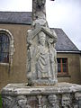
This building is inscrit au titre des monuments historiques de la France. It is indexed in the base Mérimée, a database of architectural heritage maintained by the French Ministry of Culture, under the reference PA00091361
|
| Object location | | View all coordinates using: OpenStreetMap |
|---|
cemetery cross located in Morbihan, in France .JPG) | |||||
| Upload media | |||||
| Instance of | |||||
|---|---|---|---|---|---|
| Location | Larré, Morbihan, Brittany, Western defense and security zone, Metropolitan France, France | ||||
| Street address |
| ||||
| Heritage designation |
| ||||
 | |||||
Media in category "Croix de cimetière de Larré"
The following 4 files are in this category, out of 4 total.
-
 Larré - croix de cimetière (1).JPG 2,448 × 3,264; 3.29 MB
-
 Larré - croix de cimetière (2).JPG 3,264 × 2,448; 3.48 MB
-
 Larré - croix de cimetière (3).JPG 2,448 × 3,264; 3.07 MB
-
 Larré - croix de cimetière (4).JPG 2,448 × 3,264; 2.65 MB
.JPG)
.JPG)
.JPG)