Category:Croft, Leicestershire
Jump to navigation
Jump to search
English: Croft is a small village in the district of Blaby in Leicestershire, England, off the old Fosse Way. Nearby places include Stoney Stanton, Broughton Astley, Huncote and Narborough. The Hinckley to Leicester railway line runs through the village. Croft railway station used to serve the village, but was closed as a result of the Beeching Axe.
village in Leicestershire, UK | |||||
| Upload media | |||||
| Instance of | |||||
|---|---|---|---|---|---|
| Location | Croft, Blaby, Leicestershire, East Midlands, England | ||||
 | |||||
Subcategories
This category has the following 5 subcategories, out of 5 total.
Media in category "Croft, Leicestershire"
The following 179 files are in this category, out of 179 total.
-
A frost covered Croft Hill - geograph.org.uk - 3268961.jpg 3,827 × 2,575; 3.42 MB
-
Approaching Soper's Bridge - geograph.org.uk - 5921921.jpg 4,000 × 3,000; 3.2 MB
-
Arbor Road in Croft - geograph.org.uk - 5314134.jpg 800 × 653; 149 KB
-
B ^ B on Fosse Way Roman Road (B4114) - geograph.org.uk - 5223026.jpg 640 × 480; 105 KB
-
B4114 Coventry Road - geograph.org.uk - 3268449.jpg 2,690 × 1,979; 1.45 MB
-
B4114 Coventry Road near Croft - geograph.org.uk - 3927416.jpg 1,600 × 1,183; 344 KB
-
B4114 Coventry Road towards Narborough - geograph.org.uk - 5247916.jpg 800 × 567; 137 KB
-
Below Croft Hill - geograph.org.uk - 1136390.jpg 640 × 479; 180 KB
-
Broughton Road in Croft - geograph.org.uk - 4354448.jpg 1,600 × 1,052; 450 KB
-
Cattle at the base of Croft Hill - geograph.org.uk - 3268516.jpg 2,604 × 2,374; 2.22 MB
-
Close up, Elizabeth II postbox, Croft Hill - geograph.org.uk - 5295482.jpg 1,216 × 2,262; 556 KB
-
Concrete block plant - geograph.org.uk - 1136320.jpg 640 × 479; 167 KB
-
Construction at Carlton Park - geograph.org.uk - 3268942.jpg 3,146 × 2,463; 1.66 MB
-
Cottages on The Green - geograph.org.uk - 1136354.jpg 640 × 479; 198 KB
-
Coventry Road (B4114) - geograph.org.uk - 5223025.jpg 640 × 480; 74 KB
-
Coventry Road - geograph.org.uk - 5371186.jpg 4,128 × 2,322; 4.49 MB
-
Croft - geograph.org.uk - 1312677.jpg 640 × 480; 84 KB
-
Croft Bridge - geograph.org.uk - 1136400.jpg 632 × 469; 220 KB
-
Croft Bridge - geograph.org.uk - 1136402.jpg 640 × 479; 217 KB
-
Croft Bridge, crossing the River Soar, Croft - geograph.org.uk - 2574815.jpg 4,000 × 3,000; 2.83 MB
-
Croft Cemetery - geograph.org.uk - 1136396.jpg 640 × 479; 301 KB
-
Croft cemetery - geograph.org.uk - 1312776.jpg 640 × 480; 101 KB
-
Croft centre.jpg 750 × 562; 114 KB
-
Croft Church and Croft House. - geograph.org.uk - 1136415.jpg 640 × 479; 150 KB
-
Croft footpath - geograph.org.uk - 1312783.jpg 480 × 640; 172 KB
-
Croft Glebe - geograph.org.uk - 1136397.jpg 640 × 479; 218 KB
-
Croft Glebe - geograph.org.uk - 1312770.jpg 640 × 480; 83 KB
-
Croft Heathcote Arms - geograph.org.uk - 2846961.jpg 640 × 480; 136 KB
-
Croft Hill - geograph.org.uk - 1136417.jpg 640 × 479; 165 KB
-
Croft Hill - geograph.org.uk - 2876127.jpg 2,708 × 1,692; 1.99 MB
-
Croft Hill - geograph.org.uk - 4812413.jpg 640 × 473; 84 KB
-
Croft Hill Granite - geograph.org.uk - 511715.jpg 640 × 480; 118 KB
-
Croft Hill Trig Point - geograph.org.uk - 2632263.jpg 800 × 530; 94 KB
-
Croft House - geograph.org.uk - 359880.jpg 640 × 480; 86 KB
-
Croft House and church tower - geograph.org.uk - 2876126.jpg 2,345 × 1,782; 1.99 MB
-
Croft Quarry on the edge of Narborough - geograph.org.uk - 3558934.jpg 3,264 × 2,448; 3.8 MB
-
Croft Quarry viewed from Croft Hill - geograph.org.uk - 5693675.jpg 800 × 591; 163 KB
-
Croft Quarry, aerial 2018 (1) - geograph.org.uk - 5846006.jpg 1,024 × 683; 191 KB
-
Croft Quarry, aerial 2018 (2) - geograph.org.uk - 5846014.jpg 800 × 533; 112 KB
-
Croft Signal Box - geograph.org.uk - 1136327.jpg 640 × 479; 183 KB
-
Croft Signal Box - geograph.org.uk - 1136349.jpg 640 × 479; 114 KB
-
Croft Triangulation Pillar top - geograph.org.uk - 4812415.jpg 640 × 523; 94 KB
-
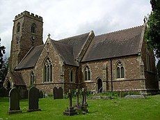
Croft, St Michael ^ All Angels - geograph.org.uk - 4532941.jpg 4,608 × 3,456; 3.97 MB
-
Croft-Thurlaston Lane - geograph.org.uk - 6110292.jpg 1,600 × 1,200; 457 KB
-
Crop field off Thurlaston Lane - geograph.org.uk - 5295169.jpg 640 × 480; 60 KB
-
Elizabeth II postbox, Croft Hill - geograph.org.uk - 5295480.jpg 2,848 × 2,136; 1.4 MB
-
Entering Croft - geograph.org.uk - 5295166.jpg 640 × 480; 95 KB
-
Entrance to Croft Glebe - geograph.org.uk - 1136392.jpg 640 × 479; 286 KB
-
Fence on Croft Hill - geograph.org.uk - 5693661.jpg 800 × 600; 160 KB
-
Fenced footpath - geograph.org.uk - 1136332.jpg 479 × 640; 129 KB
-
Footbridge across the Soar - geograph.org.uk - 1136338.jpg 479 × 640; 270 KB
-
Footpath at Croft Hill - geograph.org.uk - 2876133.jpg 2,912 × 2,280; 2.98 MB
-
Footpath at Croft Hill - geograph.org.uk - 2876136.jpg 2,433 × 2,498; 2.38 MB
-
Footpath from Hill Street to Winston Avenue - geograph.org.uk - 5807352.jpg 4,000 × 3,000; 2.57 MB
-
Footpath near Croft Hill - geograph.org.uk - 3268508.jpg 3,538 × 2,787; 2.9 MB
-
Footpath to Cosby - geograph.org.uk - 5223028.jpg 640 × 480; 100 KB
-
Footpath to Croft village - geograph.org.uk - 1136345.jpg 640 × 479; 135 KB
-
Footpath under the railway - geograph.org.uk - 1136337.jpg 479 × 640; 214 KB
-
Fosse Farm - geograph.org.uk - 4449112.jpg 640 × 426; 45 KB
-
Fosse Farm at Guthlaxton Gap - geograph.org.uk - 3268444.jpg 2,367 × 1,625; 1.51 MB
-
Fosse Way Roman Road (B4114) - geograph.org.uk - 5223027.jpg 640 × 480; 86 KB
-
Fosse Way Roman Road (B4114) - geograph.org.uk - 5223029.jpg 640 × 480; 61 KB
-
From the quarry edge - geograph.org.uk - 4812417.jpg 640 × 453; 122 KB
-
Frost on top of Croft Hill - geograph.org.uk - 3268949.jpg 4,000 × 3,000; 3.69 MB
-
Granite rocks on Croft Hill - geograph.org.uk - 2877392.jpg 2,988 × 1,969; 2.47 MB
-
Granite rocks on Croft Hill - geograph.org.uk - 3268947.jpg 4,000 × 3,000; 3.58 MB
-
Hill Street - geograph.org.uk - 1136353.jpg 640 × 479; 133 KB
-
Hillfoot Farm - geograph.org.uk - 1136380.jpg 640 × 479; 247 KB
-
Hillfoot Farm - geograph.org.uk - 1136385.jpg 640 × 479; 212 KB
-
Houses along Thurlaston Lane - geograph.org.uk - 2876131.jpg 2,815 × 2,179; 2.63 MB
-
Houses at Potters Marston - geograph.org.uk - 4189613.jpg 1,600 × 1,279; 371 KB
-
Houses in Croft - geograph.org.uk - 5371470.jpg 4,128 × 2,322; 3.53 MB
-
Houses near Croft Bridge - geograph.org.uk - 5793594.jpg 1,600 × 900; 420 KB
-
Houses near Croft Hill - geograph.org.uk - 2876132.jpg 2,853 × 1,860; 2.55 MB
-
Huncote Road - geograph.org.uk - 6829832.jpg 768 × 1,024; 261 KB
-
Huncote Road at Croft - geograph.org.uk - 5693682.jpg 800 × 561; 184 KB
-
Huncote Road near Croft Quarry - geograph.org.uk - 3927423.jpg 1,600 × 1,068; 504 KB
-
Huncote Road-Stanton Lane junction - geograph.org.uk - 4811113.jpg 640 × 492; 64 KB
-
Kissing gate and path along Huncote Road - geograph.org.uk - 4354463.jpg 1,600 × 1,161; 747 KB
-
Leaving Croft village - geograph.org.uk - 5793597.jpg 1,600 × 900; 516 KB
-
Leicester to Birmingham railway at Croft - geograph.org.uk - 1136326.jpg 640 × 479; 172 KB
-
Near Fosse Farm - geograph.org.uk - 1136313.jpg 640 × 479; 176 KB
-
No parking - geograph.org.uk - 1136346.jpg 640 × 479; 206 KB
-
North from Croft Hill - geograph.org.uk - 4812419.jpg 640 × 402; 71 KB
-
Old woodland on Croft Hill - geograph.org.uk - 2877588.jpg 3,264 × 2,448; 3.15 MB
-
Old woodland on Croft Hill - geograph.org.uk - 2877592.jpg 3,260 × 2,217; 3.1 MB
-
On Croft Hill - geograph.org.uk - 1136359.jpg 640 × 479; 188 KB
-
On Croft Hill - geograph.org.uk - 1136366.jpg 640 × 479; 153 KB
-
Passing Croft - geograph.org.uk - 1136331.jpg 640 × 479; 193 KB
-
Patch of old woodland on Croft Hill - geograph.org.uk - 2877600.jpg 2,448 × 3,264; 3.42 MB
-
Path on Croft Hill - geograph.org.uk - 4811114.jpg 640 × 485; 62 KB
-
Permissive path through Croft Glebe - geograph.org.uk - 5807359.jpg 4,000 × 3,000; 3.54 MB
-
Petroleum terminal - geograph.org.uk - 1136350.jpg 640 × 479; 118 KB
-
Railway sidings in Croft - geograph.org.uk - 3268476.jpg 2,533 × 2,193; 1.66 MB
-
Railway sidings in Croft - geograph.org.uk - 3268478.jpg 3,425 × 2,626; 2.94 MB
-
Recreation ground in Croft - geograph.org.uk - 3268469.jpg 3,134 × 2,320; 2.24 MB
-
River Soar - geograph.org.uk - 5807317.jpg 4,000 × 3,000; 2.52 MB
-
River Soar at Croft - geograph.org.uk - 1136339.jpg 640 × 479; 251 KB
-
River Soar at Croft - geograph.org.uk - 1136403.jpg 640 × 479; 232 KB
-
Road to Croft Quarry - geograph.org.uk - 3268451.jpg 2,397 × 1,754; 1.19 MB
-
Road to Croft Quarry - geograph.org.uk - 3268460.jpg 2,100 × 1,677; 651 KB
-
Sheep along Croft Lane - geograph.org.uk - 677778.jpg 640 × 474; 97 KB
-
Shops on Pochin Street in Croft - geograph.org.uk - 5314127.jpg 800 × 502; 84 KB
-
Shunting loco - geograph.org.uk - 1136323.jpg 640 × 479; 161 KB
-
Sign at Croft Hill - geograph.org.uk - 4811115.jpg 627 × 640; 168 KB
-
Small patch of woodland on Croft Hill - geograph.org.uk - 2877377.jpg 640 × 480; 152 KB
-
South east from Croft Hill - geograph.org.uk - 4812418.jpg 640 × 410; 68 KB
-
South west from Croft Hill - geograph.org.uk - 4811117.jpg 640 × 415; 31 KB
-
St Michael ^ All Angels church - geograph.org.uk - 5693689.jpg 800 × 534; 174 KB
-
Stanton Lane - geograph.org.uk - 4811118.jpg 640 × 418; 41 KB
-
Stanton Lane near Croft Hill - geograph.org.uk - 2876129.jpg 2,511 × 1,910; 1.84 MB
-
Stanton Lane sign - geograph.org.uk - 4812406.jpg 640 × 531; 166 KB
-
Station Road in Croft - geograph.org.uk - 3268488.jpg 4,000 × 3,000; 3.5 MB
-
Station Road in Croft - geograph.org.uk - 677770.jpg 640 × 446; 90 KB
-
Steps along the footpath - geograph.org.uk - 3268465.jpg 2,461 × 2,139; 1.69 MB
-
Stile and path at Croft Hill - geograph.org.uk - 2877607.jpg 2,310 × 2,891; 2.52 MB
-
Stile into water. - geograph.org.uk - 1136395.jpg 640 × 479; 222 KB
-
Stile leading to Croft Hill - geograph.org.uk - 3268515.jpg 3,014 × 2,603; 2.22 MB
-
Sutton Hill Farm - geograph.org.uk - 5223022.jpg 640 × 480; 80 KB
-
Terrace Cottages - geograph.org.uk - 1136406.jpg 640 × 479; 124 KB
-
Terrace on The Green - geograph.org.uk - 1136352.jpg 640 × 479; 180 KB
-
The B4114 Fosse Way towards Narborough - geograph.org.uk - 4329459.jpg 1,600 × 1,242; 538 KB
-
The Fosse Way (B4114 leading to Narborough) - geograph.org.uk - 2574824.jpg 4,000 × 3,000; 2.89 MB
-
The Heathcote Arms in Croft - geograph.org.uk - 5693694.jpg 800 × 662; 150 KB
-
The Old School - geograph.org.uk - 1136398.jpg 640 × 479; 148 KB
-
The road to Huncote - geograph.org.uk - 5813100.jpg 1,600 × 900; 612 KB
-
The summit of Croft Hill - geograph.org.uk - 4162761.jpg 1,600 × 1,200; 513 KB
-
The western edge of Croft Quarry - geograph.org.uk - 4354471.jpg 1,600 × 1,315; 499 KB
-
Through the trees on Croft Hill - geograph.org.uk - 4812407.jpg 640 × 500; 204 KB
-
Thurlaston Lane - geograph.org.uk - 5295170.jpg 640 × 480; 80 KB
-
Towards Huncote - geograph.org.uk - 4812408.jpg 640 × 526; 190 KB
-
Towards the Heathcote Arms - geograph.org.uk - 4812412.jpg 640 × 458; 83 KB
-
Traffic on the B4114 Coventry Road - geograph.org.uk - 5247897.jpg 800 × 647; 83 KB
-
Tree and hollow on Croft Hill - geograph.org.uk - 3268959.jpg 3,664 × 2,528; 2.79 MB
-
Trees at Croft Hill - geograph.org.uk - 2876138.jpg 3,264 × 2,448; 3.5 MB
-
Trees at the base of Croft Hill - geograph.org.uk - 3268963.jpg 3,686 × 2,651; 3.01 MB
-
Trees near the summit of Croft Hill - geograph.org.uk - 3268955.jpg 3,997 × 2,890; 3.37 MB
-
Trees on Croft Hill - geograph.org.uk - 4812409.jpg 640 × 483; 136 KB
-
Trees on the slopes of Croft Hill - geograph.org.uk - 5693645.jpg 800 × 548; 128 KB
-
View east from Croft Hill - geograph.org.uk - 4163767.jpg 1,600 × 1,375; 428 KB
-
View from Croft Hill - geograph.org.uk - 511666.jpg 640 × 464; 94 KB
-
View from Croft Hill - geograph.org.uk - 511678.jpg 640 × 463; 100 KB
-
View north from Croft Hill - geograph.org.uk - 2877429.jpg 3,264 × 2,448; 3.13 MB
-
View northwest to Croft Hill - geograph.org.uk - 4163807.jpg 1,600 × 1,194; 441 KB
-
View of Fosse Way northbound - geograph.org.uk - 6480118.jpg 768 × 1,024; 260 KB
-
View of Leicestershire - geograph.org.uk - 2632274.jpg 800 × 530; 79 KB
-
View towards Potters Marston - geograph.org.uk - 2877580.jpg 3,264 × 2,448; 3.87 MB
-
View up Croft Hill - geograph.org.uk - 3268526.jpg 2,964 × 2,248; 2.59 MB
-
Waymarks - geograph.org.uk - 1136391.jpg 640 × 479; 230 KB
-
Westwards from Croft Hill - geograph.org.uk - 4812410.jpg 640 × 399; 79 KB
-
Wilson Avenue - geograph.org.uk - 1136347.jpg 640 × 479; 131 KB
-
Wind turbine near Croft Quarry - geograph.org.uk - 2877566.jpg 2,410 × 2,455; 2.1 MB
-
Approaching Croft Hill - geograph.org.uk - 511641.jpg 640 × 564; 125 KB
-
B4114 Coventry Road near Broughton Astley - geograph.org.uk - 510804.jpg 640 × 547; 134 KB
-
Bridleway to Sapcote - geograph.org.uk - 215365.jpg 640 × 480; 108 KB
-
Coventry Road Junction - geograph.org.uk - 510778.jpg 640 × 561; 113 KB
-
Croft Fun Park - geograph.org.uk - 215356.jpg 640 × 480; 93 KB
-
Croft Hill from Stanton Lane - geograph.org.uk - 511620.jpg 640 × 432; 99 KB
-
Croft Hill Triangulation Pillar - geograph.org.uk - 511707.jpg 640 × 480; 100 KB
-
Derelict farm building - geograph.org.uk - 510800.jpg 640 × 523; 119 KB
-
Junction on Coventry Road, Croft - geograph.org.uk - 229385.jpg 640 × 427; 92 KB
-
Leaving Croft Car Boot Sale - geograph.org.uk - 215361.jpg 640 × 480; 100 KB
-
Memorial to the People of Croft - geograph.org.uk - 215374.jpg 480 × 640; 116 KB
-
Public Footpath at Croft Hill - geograph.org.uk - 511649.jpg 640 × 480; 163 KB
-
The B4114 Coventry Road - geograph.org.uk - 511801.jpg 640 × 549; 109 KB
-
The Old Rectory, Croft - geograph.org.uk - 359867.jpg 640 × 480; 123 KB
-
Thurlaston Brook at Stony Bridge - geograph.org.uk - 169106.jpg 640 × 427; 225 KB
-
Thurlaston Lane, Leicestershire - geograph.org.uk - 169118.jpg 640 × 427; 181 KB


