Category:Created with QGIS and Inkscape
Jump to navigation
Jump to search
Media in category "Created with QGIS and Inkscape"
The following 27 files are in this category, out of 27 total.
-
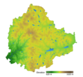
Bangalore elevation map with waterbodies.png 2,015 × 1,858; 1.36 MB
-
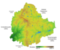
Bangalore elevation with NS ridge and valley labels.png 1,371 × 1,141; 929 KB
-
Cincinnati Bike Map - Indexed Color Version.png 14,117 × 9,305; 18.72 MB
-
Cincinnati Bike Map East Side.png 7,204 × 9,303; 38.55 MB
-
Cincinnati Bike Map Full Color.png 14,148 × 9,304; 69.65 MB
-
Cincinnati Bike Map Legend.png 1,198 × 910; 152 KB
-
Cincinnati Bike Map West Side.png 7,210 × 9,303; 31.67 MB
-
Day Boulevard.png 1,676 × 986; 330 KB
-
Fenway (parkway).png 1,440 × 847; 524 KB
-
Furnace Brook Parkway.png 1,000 × 588; 349 KB
-
Interstate 495 Massachusetts.png 2,598 × 1,529; 1,015 KB
-
Interstate 95 in Massachusetts.png 2,598 × 1,529; 1,013 KB
-
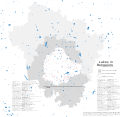
Lakes in Bangalore, BBMP, Urban district, Rural district.svg 6,441 × 6,286; 3.11 MB
-
Lakes in Bangalore.svg 934 × 730; 2.12 MB
-
Map of US 66.png 936 × 576; 102 KB
-
Massachusetts Route 2.png 2,598 × 1,529; 1,013 KB
-
Massachusetts Route 3.png 2,598 × 1,529; 1,012 KB
-
Massachusetts Route 75.png 1,149 × 675; 39 KB
-
Massachusetts Route 83.png 1,149 × 676; 26 KB
-
Metropolitan Park System Boston.png 1,460 × 1,369; 467 KB
-
Morrissey Boulevard.png 1,780 × 2,639; 667 KB
-
North Shore MA.png 1,600 × 1,000; 403 KB
-
Ok-17 path.png 3,425 × 2,031; 307 KB
-
Ok-17A path.png 3,425 × 2,031; 179 KB
-
Park Drive Boston.png 1,440 × 847; 526 KB
-
Soldiers Field Road.png 1,284 × 755; 219 KB
-
South Shore MA.png 1,091 × 683; 300 KB


