Category:Cold Ashton
Jump to navigation
Jump to search
village in the United Kingdom  | |||||
| Upload media | |||||
| Instance of | |||||
|---|---|---|---|---|---|
| Location | South Gloucestershire, Gloucestershire, South West England, England | ||||
| Population |
| ||||
 | |||||
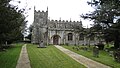
English: Cold Ashton is a village in South Gloucestershire, England. The village church has a 14th century tower and the rest of the church was rebuilt in the 16th century by Thomas Key, its rector.cite book
Bahasa Indonesia: Cold Ashton adalah sebuah desa di South Gloucestershire, Inggris. Gereja desa memiliki sebuah menara abad ke-14 dan keseluruhan gereja dibangun kembali di abad ke-16 oleh Thomas Key, penjaganya.cite book
Subcategories
This category has the following 8 subcategories, out of 8 total.
B
H
- Hamswell House (2 F)
M
- Monkswood Reservoir (5 F)
N
- Nimlet, Gloucestershire (3 F)
R
- RAF Charmy Down (16 F)
W
Media in category "Cold Ashton"
The following 200 files are in this category, out of 290 total.
(previous page) (next page)-

-
 2010 , A420 near Cold Ashton - geograph.org.uk - 1846113.jpg 800 × 520; 86 KB
-

-
 2010 , Beek's Farm - geograph.org.uk - 1839585.jpg 1,024 × 810; 191 KB
-
 2010 , Downhill on Leigh Lane - geograph.org.uk - 1839634.jpg 640 × 499; 158 KB
-
 2010 , East from Leigh Lane - geograph.org.uk - 1839497.jpg 640 × 358; 49 KB
-

-

-
 2010 , Link road between A420 and A46 - geograph.org.uk - 1846428.jpg 800 × 596; 147 KB
-

-

-

-

-

-

-
 A farm track leading to Goudie's Farm - geograph.org.uk - 3457044.jpg 800 × 600; 158 KB
-
 A field of dandelions - geograph.org.uk - 1878919.jpg 1,024 × 683; 292 KB
-
 A field of oats near Shrubbery Farm - geograph.org.uk - 5127612.jpg 6,000 × 4,000; 4.62 MB
-
 A post box at Cold Ashton - geograph.org.uk - 3456787.jpg 800 × 600; 143 KB
-
 A stand of trees on a hilltop - geograph.org.uk - 4896800.jpg 2,304 × 1,704; 1.1 MB
-
 A walk to the church and beyond - geograph.org.uk - 4898128.jpg 1,704 × 2,304; 2.16 MB
-
 A420 approaches Tog Hill - geograph.org.uk - 2614719.jpg 3,284 × 2,728; 1.06 MB
-
 A46 6 miles to Bath - geograph.org.uk - 4123708.jpg 1,600 × 1,041; 384 KB
-
 A46 at Nimlet - geograph.org.uk - 1904108.jpg 640 × 480; 212 KB
-
 A46 enters Bath and North East Somerset - geograph.org.uk - 4123714.jpg 1,600 × 1,106; 388 KB
-
 Adding to the character - geograph.org.uk - 4896828.jpg 2,304 × 1,704; 1.47 MB
-
 Another forbidding road sign - geograph.org.uk - 5573338.jpg 3,264 × 2,448; 2 MB
-

-
 Bank and Ditch, Freezing Hill. - geograph.org.uk - 1821299.jpg 1,600 × 1,197; 954 KB
-
 Beeches near Lansdown - geograph.org.uk - 3831754.jpg 456 × 640; 310 KB
-
 Bench on the Cotswold Way - geograph.org.uk - 5441893.jpg 4,896 × 3,264; 6.45 MB
-
 Brook Cottage, Lower Hamswell, Cold Ashton, Gloucestershire.jpg 4,096 × 1,940; 2.88 MB
-
 Buckling under the weight - geograph.org.uk - 4896774.jpg 2,304 × 1,704; 1.79 MB
-
 Building project, Lower Hamswell - geograph.org.uk - 6343451.jpg 4,288 × 2,848; 1.72 MB
-

-
 By Little Moody's Wood - geograph.org.uk - 797577.jpg 640 × 457; 145 KB
-
 Cattle in the shade near Brook Cottage - geograph.org.uk - 5131070.jpg 6,000 × 4,000; 4.91 MB
-
 Change of priorities at The Lynch - geograph.org.uk - 4896732.jpg 2,304 × 1,704; 1.34 MB
-
 Charmy Down - geograph.org.uk - 118865.jpg 640 × 480; 49 KB
-
 Chasing the frost - geograph.org.uk - 2803935.jpg 2,304 × 1,704; 1.39 MB
-
 Church of the Holy Trinity, Cold Ashton - geograph.org.uk - 5475742.jpg 3,776 × 2,520; 4.4 MB
-
 Churchyard of Holy Trinity, Cold Ashton - geograph.org.uk - 5128477.jpg 6,000 × 4,000; 4.9 MB
-
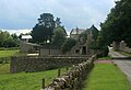
 Cold Ashton - geograph.org.uk - 6344042.jpg 4,016 × 2,750; 1.58 MB
-
 Cold Ashton - geograph.org.uk - 6344152.jpg 4,288 × 2,848; 1.47 MB
-
 Cold Ashton - geograph.org.uk - 6344316.jpg 4,279 × 2,681; 1.53 MB
-
 Cold Ashton - Holy Trinity Church - geograph.org.uk - 5218575.jpg 5,184 × 2,920; 6.16 MB
-
 Cold Ashton Manor House - geograph.org.uk - 5218569.jpg 5,184 × 2,920; 6.51 MB
-
 Cold Ashton Parish Hall - geograph.org.uk - 5475723.jpg 3,776 × 2,520; 4.07 MB
-
 Cold Ashton Roundabout - geograph.org.uk - 82347.jpg 640 × 480; 82 KB
-
 Cold Ashton sign at The Lynch - geograph.org.uk - 5533610.jpg 640 × 427; 83 KB
-
 Cold Ashton village hall - geograph.org.uk - 4896727.jpg 2,304 × 1,704; 1.34 MB
-
 Cold Ashton, UK - panoramio.jpg 2,479 × 1,897; 3.08 MB
-
 Cold side of the hill - geograph.org.uk - 2803939.jpg 2,304 × 1,704; 1.47 MB
-
 Cotswold Way approaching Cold Ashton - geograph.org.uk - 6344791.jpg 4,288 × 2,848; 2.14 MB
-
 Cotswold Way at Rectory Farm - geograph.org.uk - 6344673.jpg 4,141 × 2,690; 1.8 MB
-
 Cotswold Way at the A420 - geograph.org.uk - 6344807.jpg 4,288 × 2,848; 1.98 MB
-
 Cottage at Nimlet - geograph.org.uk - 6313107.jpg 2,400 × 1,457; 1.18 MB
-
 Cottages on Hyde's Lane - geograph.org.uk - 5128486.jpg 6,000 × 4,000; 4.58 MB
-
 Crossing paths - geograph.org.uk - 4896717.jpg 1,704 × 2,304; 2.11 MB
-
 Derelict pub on the A420 - geograph.org.uk - 3656319.jpg 640 × 480; 68 KB
-
 Down to St Catherine's - geograph.org.uk - 4896750.jpg 2,304 × 1,704; 1.38 MB
-
 Dry but with beautiful interiors - geograph.org.uk - 4896822.jpg 2,304 × 1,704; 1.64 MB
-
 East from Hyde's Lane near Cold Ashton - geograph.org.uk - 914917.jpg 2,921 × 2,079; 3.25 MB
-

-
 Easy travelling - geograph.org.uk - 4896756.jpg 2,304 × 1,704; 1.62 MB
-
 Economic activity comparison graph (CA, SG, N).png 480 × 289; 8 KB
-
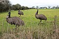 Emus, Folly Farm - geograph.org.uk - 6344694.jpg 4,288 × 2,848; 2.16 MB
-
 Farmland by the A46 - geograph.org.uk - 4882807.jpg 1,600 × 1,067; 478 KB
-
 Field beside Freezing Hill Lane - geograph.org.uk - 6343242.jpg 3,975 × 2,635; 1.26 MB
-
 Field by Lilliput Farm - geograph.org.uk - 6343429.jpg 4,132 × 2,452; 1.64 MB
-
 Field entrance off Greenway Lane - geograph.org.uk - 5129671.jpg 6,000 × 4,000; 5.23 MB
-
 Field near Folly Farm - geograph.org.uk - 6344749.jpg 4,288 × 2,848; 2.07 MB
-
 Field near The Folly - geograph.org.uk - 6344776.jpg 4,288 × 2,848; 2.14 MB
-
 Field of cut grass above Hill Farm - geograph.org.uk - 5129686.jpg 6,000 × 4,000; 4.4 MB
-
 Fields near Pennsylvania - geograph.org.uk - 5127611.jpg 6,000 × 4,000; 4.04 MB
-
 Fields on the south side of Tog Hill - geograph.org.uk - 5129663.jpg 6,000 × 4,000; 5.33 MB
-
 Fields viewed from the Limestone Link path - geograph.org.uk - 4143346.jpg 1,280 × 720; 758 KB
-
 Flush Bracket S0480 - White Hart Inn - geograph.org.uk - 2326274.jpg 1,704 × 2,304; 1.8 MB
-
 Following the footpath - geograph.org.uk - 797582.jpg 640 × 457; 118 KB
-
 Footpath by wall - geograph.org.uk - 4896810.jpg 2,304 × 1,704; 1.82 MB
-
 Footpath from Cold Ashton - geograph.org.uk - 5128493.jpg 6,000 × 4,000; 5.33 MB
-
 Footpath from the A46 - geograph.org.uk - 6344850.jpg 2,814 × 3,555; 1.58 MB
-
 Footpath to Cold Ashton - geograph.org.uk - 5128457.jpg 6,000 × 4,000; 5.31 MB
-
 Footpath to Pennsylvania - geograph.org.uk - 5128464.jpg 6,000 × 4,000; 5.08 MB
-
 Footpath to Tog Hill - geograph.org.uk - 5129656.jpg 6,000 × 4,000; 6.07 MB
-
 Former White Hart pub, Cold Ashton, Chippenham, Gloucestershire.jpg 3,600 × 1,832; 1.44 MB
-
 Freezing Hill - geograph.org.uk - 713524.jpg 640 × 460; 101 KB
-
 Freezing Hill Lane near Lower Hamswell - geograph.org.uk - 3831777.jpg 571 × 640; 184 KB
-
 From Cold Ashton - geograph.org.uk - 6344430.jpg 4,277 × 2,440; 1.88 MB
-
 Fuel Filling Station - Pennsylvania - geograph.org.uk - 6217857.jpg 2,507 × 1,401; 1.19 MB
-
 Garden wall and gateway to the Manor House, Cold Ashton - geograph.org.uk - 5475733.jpg 3,776 × 2,520; 4.08 MB
-
 Gate from churchyard, Cold Ashton - geograph.org.uk - 6344439.jpg 4,135 × 2,769; 2.2 MB
-
 Gorse Lane - geograph.org.uk - 6344009.jpg 4,228 × 2,743; 1.42 MB
-
 Gorse Lane - geograph.org.uk - 6344018.jpg 3,853 × 2,347; 1.08 MB
-
 Goudie's Farm no.2 - geograph.org.uk - 719626.jpg 640 × 443; 102 KB
-

-
 Green over the red - geograph.org.uk - 4896735.jpg 1,704 × 2,304; 1.93 MB
-
 Greenway Lane - geograph.org.uk - 1095615.jpg 640 × 490; 199 KB
-
 Greenway Lane - geograph.org.uk - 5475670.jpg 3,776 × 2,520; 4.21 MB
-
 Greenway Lane near the top of the Cotswold escarpment - geograph.org.uk - 5475692.jpg 3,776 × 2,520; 3.39 MB
-
 Greenways Lane - geograph.org.uk - 1804541.jpg 2,304 × 3,072; 2.33 MB
-
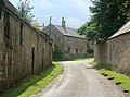
 Hall Lane - geograph.org.uk - 6343193.jpg 4,271 × 2,501; 1.58 MB
-
 Hall Lane - geograph.org.uk - 6343336.jpg 4,288 × 2,848; 1.68 MB
-
 Hall Lane - geograph.org.uk - 6343436.jpg 2,848 × 4,288; 2.53 MB
-
 Hall Lane - geograph.org.uk - 6343444.jpg 4,288 × 2,848; 2.35 MB
-
 Hall Lane - geograph.org.uk - 6343448.jpg 4,288 × 2,848; 2.08 MB
-
 Hall Lane near Lower Hamswell - geograph.org.uk - 3831768.jpg 640 × 477; 247 KB
-
 Heading towards Lansdown Hill - geograph.org.uk - 3457080.jpg 800 × 600; 147 KB
-
 Henley Hill - geograph.org.uk - 6344863.jpg 4,288 × 2,848; 2.27 MB
-
 Henley Hill and the road to Henley Tyning - geograph.org.uk - 5237728.jpg 1,600 × 1,067; 560 KB
-
 Highways Agency Automated Weather Station near Cold Ashton. - panoramio.jpg 2,112 × 2,816; 1.31 MB
-
 Hill Farm - geograph.org.uk - 5129693.jpg 6,000 × 4,000; 4.26 MB
-
 Hill Farm, Greenway Lane - geograph.org.uk - 1100384.jpg 640 × 481; 163 KB
-
 Hillside near Battlefields - geograph.org.uk - 6343225.jpg 4,288 × 2,848; 2.28 MB
-
 Holy Trinity - geograph.org.uk - 4897790.jpg 2,304 × 1,704; 1.66 MB
-
 Holy Trinity - geograph.org.uk - 4897802.jpg 2,304 × 1,704; 1.77 MB
-
 Holy Trinity Church, Cold Ashton - geograph.org.uk - 6390856.jpg 1,024 × 576; 176 KB
-
 Holy Trinity graveyard - geograph.org.uk - 4897807.jpg 2,304 × 1,704; 1.73 MB
-
 Hyde's Lane, Cold Ashton - geograph.org.uk - 3456760.jpg 800 × 600; 162 KB
-
 Hyde's Lane, Cold Ashton - geograph.org.uk - 3456774.jpg 800 × 600; 155 KB
-
 Hyde's Lane, Cold Ashton - geograph.org.uk - 3456802.jpg 800 × 600; 152 KB
-
 Hyde's Lane, Cold Ashton - geograph.org.uk - 3456824.jpg 800 × 600; 139 KB
-
 Hyde's Lane, Cold Ashton - geograph.org.uk - 914513.jpg 640 × 435; 68 KB
-
 Iron Age Earthworks on Freezing Hill - geograph.org.uk - 1821293.jpg 1,600 × 1,197; 833 KB
-
 Is it British Summertime^ - geograph.org.uk - 4897797.jpg 1,704 × 2,304; 1.49 MB
-
-
 Keeping an eye on the kids - geograph.org.uk - 4896710.jpg 2,304 × 1,704; 1.54 MB
-
 Lane in Cold Ashton - geograph.org.uk - 5129536.jpg 6,000 × 4,000; 3.94 MB
-
 Leigh Lane - geograph.org.uk - 4882824.jpg 1,600 × 1,066; 435 KB
-
 Leigh Lane - geograph.org.uk - 6344876.jpg 1,869 × 2,541; 736 KB
-
 Leigh Lane - geograph.org.uk - 6344880.jpg 4,288 × 2,848; 1.94 MB
-

-
 Lilliput Farm (geograph 6343316).jpg 4,221 × 2,753; 1.33 MB
-
 Limestone Link near Monkswood - geograph.org.uk - 6344885.jpg 4,288 × 2,848; 2.41 MB
-
 Limestone Link near Monkswood - geograph.org.uk - 6344891.jpg 3,885 × 2,173; 1.9 MB
-
 Line of footpath from A46 - geograph.org.uk - 6344856.jpg 2,848 × 4,288; 2.11 MB
-
 Line of footpath near Folly Farm - geograph.org.uk - 6344700.jpg 4,288 × 2,848; 2.16 MB
-
 Listed barn, Cold Ashton (geograph 6344338).jpg 4,288 × 2,848; 1.79 MB
-
 Looking across the valley to Beek's Farm - geograph.org.uk - 4143352.jpg 1,280 × 720; 887 KB
-
 Looking back towards Pennsylvania - geograph.org.uk - 3456541.jpg 800 × 600; 133 KB
-
 Looking south on the A46 - geograph.org.uk - 1037517.jpg 640 × 467; 178 KB
-
 Lurking in the foliage - geograph.org.uk - 2803945.jpg 1,704 × 2,304; 1.33 MB
-
 Manor House, Cold Ashton - geograph.org.uk - 5129523.jpg 6,000 × 4,000; 5.03 MB
-
 Meadow on the side of Lansdown Hill - geograph.org.uk - 5131087.jpg 6,000 × 4,000; 6.37 MB
-
 Myrtle Cottage, Cold Ashton, Chippenham, Gloucestershire.jpg 2,515 × 1,886; 968 KB
-
 North west from Hall Lane - geograph.org.uk - 1650549.jpg 640 × 483; 81 KB
-
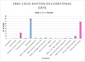 Occupational data cold ashton.jpg 604 × 441; 54 KB
-
 Old Barn next to the Court House - geograph.org.uk - 4898105.jpg 2,304 × 1,704; 1.56 MB
-
 Old farm buildings on Nimlet Hill - geograph.org.uk - 4882819.jpg 1,600 × 1,066; 527 KB
-
 Old Rectory and Manor House, Cold Ashton (geograph 6344403).jpg 3,852 × 2,246; 1.33 MB
-
 Old Rectory, Cold Ashton - geograph.org.uk - 1835612.jpg 1,600 × 1,197; 834 KB
-
 Old Rectory, Cold Ashton - geograph.org.uk - 1878883.jpg 1,024 × 683; 177 KB
-

-
 Ordnance Survey Bench Mark - geograph.org.uk - 6390858.jpg 576 × 1,024; 205 KB
-
 Ornamental gateway - geograph.org.uk - 4898120.jpg 1,704 × 2,304; 1.92 MB
-
 Outbuildings at Folly Farm - geograph.org.uk - 1228557.jpg 640 × 522; 122 KB
-
 Parkfield Farm - geograph.org.uk - 6340957.jpg 3,468 × 2,092; 1,007 KB
-
 Pasture in Cold Ashton - geograph.org.uk - 2994117.jpg 1,024 × 768; 200 KB
-
 Path from Hyde's Lane - geograph.org.uk - 4896777.jpg 2,304 × 1,704; 1.64 MB
-
 Path to the A420 - geograph.org.uk - 6344682.jpg 4,288 × 2,848; 2.11 MB
-
 Pig houses at Folly Farm - geograph.org.uk - 5127615.jpg 6,000 × 4,000; 5.3 MB
-
 Plant centre on Greenway Lane - geograph.org.uk - 1100380.jpg 640 × 489; 299 KB
-
 Plenty of work to do - geograph.org.uk - 4896743.jpg 2,304 × 1,704; 1.69 MB
-
 Post box on Hyde's Lane, Cold Ashton - geograph.org.uk - 3456791.jpg 600 × 800; 182 KB
-
 Postbox outside Manor House, Cold Ashton - geograph.org.uk - 6344351.jpg 3,673 × 2,431; 2.36 MB
-
 Reservoir dam near Hamswell - geograph.org.uk - 5131043.jpg 6,000 × 4,000; 5.07 MB
-
 Room outside - geograph.org.uk - 4897804.jpg 2,304 × 1,704; 1.54 MB
-
 Shackells Fishing Lake - geograph.org.uk - 1821315.jpg 1,914 × 1,269; 390 KB
-
 Shackells Lake - geograph.org.uk - 1835637.jpg 640 × 479; 94 KB
-
 Sharp turn at the lodge - geograph.org.uk - 2803951.jpg 2,304 × 1,704; 1.66 MB
-
 Sheep near Cold Ashton - geograph.org.uk - 5129543.jpg 6,000 × 4,000; 4.31 MB
-
 Shell filling station, Pennsylvania, on A46 - geograph.org.uk - 5237725.jpg 1,600 × 1,201; 675 KB
-
 Shell garage at Pennsylvania - geograph.org.uk - 5534229.jpg 640 × 462; 67 KB
-
 Shepherd's hut at Hill Farm - geograph.org.uk - 5443225.jpg 4,896 × 3,264; 6.48 MB
-
 Slough Lane - geograph.org.uk - 6344840.jpg 3,727 × 2,116; 1.16 MB
-
 South east from Freezing Hill - geograph.org.uk - 918685.jpg 640 × 408; 51 KB
-

-

-

-
 South from Hyde's Lane, Cold Ashton - geograph.org.uk - 914904.jpg 640 × 451; 86 KB
-
 South porch - geograph.org.uk - 4897794.jpg 2,304 × 1,704; 1.68 MB
-
 Special Plants Nursery - geograph.org.uk - 3750240.jpg 800 × 450; 250 KB
-
 Special Plants Nursery, Greenway Lane, Cold Ashton - geograph.org.uk - 5475679.jpg 3,776 × 2,520; 4.27 MB
-

-
 St. Catherines Valley. - panoramio.jpg 2,816 × 2,112; 2.74 MB
-
 Striped caterpillar - geograph.org.uk - 4898142.jpg 1,704 × 2,304; 1.36 MB
-
 Sunset at Cold Ashton - geograph.org.uk - 2852856.jpg 2,576 × 1,932; 373 KB
-
 Tadwick Ford - geograph.org.uk - 4972006.jpg 1,500 × 842; 1.7 MB
-
 Tadwick Lane - geograph.org.uk - 4882816.jpg 1,600 × 1,066; 491 KB
-
 Tadwick Lane - geograph.org.uk - 713628.jpg 640 × 497; 160 KB
-
 The A420 Towards Bristol - geograph.org.uk - 6217853.jpg 4,128 × 2,006; 3.57 MB
-
 The A420, Cold Ashton - geograph.org.uk - 6173573.jpg 1,864 × 1,190; 1.4 MB
-
 The A420, Toghill - geograph.org.uk - 6173576.jpg 1,824 × 1,114; 1,008 KB
-
 The A420-A46 junction at Cold Ashton - geograph.org.uk - 6171745.jpg 1,920 × 1,280; 810 KB
-
 The A46 northwards through Pennsylvania - geograph.org.uk - 3432136.jpg 3,648 × 2,736; 1.69 MB
-
 The A46 through Pennsylvania - geograph.org.uk - 5128452.jpg 6,000 × 4,000; 3.5 MB
-
 The A46 through Pennsylvania - geograph.org.uk - 5475753.jpg 3,776 × 2,520; 3.94 MB
-
 The Cold Ashton Parish Hall - geograph.org.uk - 3456839.jpg 800 × 600; 132 KB
-
 The Cotswold Way - geograph.org.uk - 1804545.jpg 3,072 × 2,304; 1.17 MB
-
 The Cotswold Way - geograph.org.uk - 3456544.jpg 800 × 600; 162 KB


_White_Hart_-_geograph.org.uk_-_3656327.jpg)


.png)


.jpg)


.jpg)


.jpg)


