Category:Cass River (Selwyn District)
Jump to navigation
Jump to search
river in Selwyn District, Canterbury Region, New Zealand  | |||||
| Upload media | |||||
| Instance of | |||||
|---|---|---|---|---|---|
| Named after | |||||
| Location | Selwyn District, Canterbury Region, New Zealand | ||||
| Length |
| ||||
| Mouth of the watercourse | |||||
| Different from | |||||
 | |||||
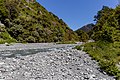
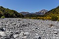
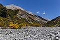
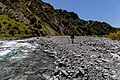
The Cass River is an alpine river in the Canterbury Region of the South Island of New Zealand. It rises near the Cass Saddle in the Craigieburn Forest Park and flows generally northeast alongside the Craigieburn Range before turning north to meet the Waimakariri River.
Media in category "Cass River (Selwyn District)"
The following 16 files are in this category, out of 16 total.
-
 Cass River 01.jpg 4,752 × 3,168; 4.33 MB
-
 Cass River 02.jpg 4,752 × 3,168; 3.96 MB
-
 Cass River 03.jpg 3,168 × 4,752; 3.45 MB
-
 Cass River along Lagoon Saddle Track, Canterbury, New Zealand 02.jpg 5,472 × 3,292; 10.55 MB
-
 Cass River along Lagoon Saddle Track, Canterbury, New Zealand.jpg 4,880 × 2,822; 7.02 MB
-
 Cass River near Cass.jpg 4,080 × 2,720; 11.31 MB
-
 Cass River, Craigieburn Forest Park, New Zealand 12.jpg 5,472 × 3,648; 16.24 MB
-
 Cass River, Craigieburn Forest Park, New Zealand 13.jpg 4,998 × 3,332; 13.31 MB
-
 Cass River, Craigieburn Forest Park, New Zealand 14.jpg 5,472 × 3,648; 19.68 MB
-
 Cass River, Craigieburn Forest Park, New Zealand 16.jpg 5,472 × 3,648; 16 MB
-
 Cass River, Craigieburn Forest Park, New Zealand 18.jpg 5,472 × 3,648; 14.42 MB
-
 Cass River, Craigieburn Forest Park, New Zealand 20.jpg 5,472 × 3,648; 15.8 MB
-
 Cass River, Craigieburn Forest Park, New Zealand 22.jpg 5,472 × 3,648; 14.8 MB
-
 Driving piles for the Cass River bridge (Midland Line).jpg 385 × 512; 43 KB
-
 Romulus, Craigieburn Forest Park, New Zealand.jpg 5,472 × 3,648; 14.19 MB
-
 Tramper by Cass River, Craigieburn Forest Park, New Zealand 17.jpg 5,472 × 3,648; 16.8 MB


.jpg)

