Category:Broad Hinton
Jump to navigation
Jump to search
village in the United Kingdom  | |||||
| Upload media | |||||
| Instance of | |||||
|---|---|---|---|---|---|
| Location | Wiltshire, South West England, England | ||||
| Population |
| ||||
| official website | |||||
 | |||||
Nederlands: Broad Hinton is een dorp (village) en civil parish in de unitary authority Wiltshire, in het Engelse graafschap Wiltshire. De civil parish telt
Subcategories
This category has the following 3 subcategories, out of 3 total.
B
U
- Uffcott, Wiltshire (35 F)
Media in category "Broad Hinton"
The following 200 files are in this category, out of 220 total.
(previous page) (next page)-
 A large field below Hackpen Hill - geograph.org.uk - 3797923.jpg 1,536 × 1,152; 993 KB
-
 A trio of stiles - geograph.org.uk - 3102447.jpg 4,320 × 3,240; 5.04 MB
-
 A4361 towards Avebury - geograph.org.uk - 6326523.jpg 640 × 480; 92 KB
-
 A4361 towards Avebury - geograph.org.uk - 6326529.jpg 640 × 480; 72 KB
-
 A4361 towards Avebury - geograph.org.uk - 6326548.jpg 800 × 600; 101 KB
-
 Across the drive - geograph.org.uk - 3102537.jpg 4,320 × 3,240; 5.08 MB
-
 Aerial View of Hackpen White Horse, Wiltshire - geograph.org.uk - 4481419.jpg 1,920 × 1,080; 1.07 MB
-
 Approaching Elm Cross on the A4361 - geograph.org.uk - 6326538.jpg 800 × 600; 94 KB
-
 Arable field by Fiddler's Hill - geograph.org.uk - 5674357.jpg 2,700 × 2,025; 636 KB
-
 Barbury Castle from Uffcott - geograph.org.uk - 4773817.jpg 3,264 × 2,448; 1.98 MB
-

-
 Beech Clump - geograph.org.uk - 4902408.jpg 4,608 × 3,072; 3.45 MB
-
 Beech Clump - geograph.org.uk - 4902418.jpg 4,608 × 3,072; 3.13 MB
-
 Beech plantation, Hackpen Hill - geograph.org.uk - 4774533.jpg 2,997 × 2,328; 4.08 MB
-
 Bend in the road on Hackpen Hill - geograph.org.uk - 3798084.jpg 1,536 × 771; 540 KB
-
 Bridleway gate - geograph.org.uk - 3102606.jpg 4,320 × 3,240; 5.11 MB
-
 Bridleway to Winterbourne Bassett - geograph.org.uk - 4165562.jpg 1,024 × 768; 137 KB
-

-
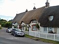
 Thatched Well Cottages in Broad Hinton - geograph.org.uk - 1566312.jpg 640 × 480; 150 KB
-
 Broad Hinton - geograph.org.uk - 6571108.jpg 1,200 × 800; 1.14 MB
-
 Broad Hinton buildings (1) - geograph.org.uk - 3102384.jpg 4,320 × 3,240; 4.52 MB
-
 Broad Hinton buildings (2) - geograph.org.uk - 3102386.jpg 4,320 × 3,240; 5 MB
-
 Broad Hinton buildings (3) - geograph.org.uk - 3102401.jpg 4,320 × 3,240; 4.86 MB
-
 Broad Hinton buildings (4) - geograph.org.uk - 6272914.jpg 4,320 × 3,240; 3.81 MB
-
 Broad Hinton buildings (5) - geograph.org.uk - 6272920.jpg 4,223 × 3,167; 3.67 MB
-
 Broad Hinton buildings (6) - geograph.org.uk - 6272921.jpg 4,320 × 3,240; 3.38 MB
-
 Broad Hinton buildings (7) - geograph.org.uk - 6272926.jpg 4,223 × 3,167; 2.55 MB
-
 Broad Hinton houses (1) (geograph 6271912).jpg 4,177 × 3,133; 2.88 MB
-
 Broad Hinton houses (10) (geograph 6272924).jpg 4,320 × 3,240; 3.36 MB
-
 Broad Hinton houses (11) - geograph.org.uk - 6272925.jpg 4,320 × 3,240; 3.38 MB
-
 Broad Hinton houses (2) (geograph 6271913).jpg 4,320 × 3,240; 2.6 MB
-
 Broad Hinton houses (3) (geograph 6271914).jpg 4,320 × 3,240; 2.47 MB
-
 Broad Hinton houses (4) (geograph 6271915).jpg 4,320 × 3,240; 3.06 MB
-
 Broad Hinton houses (5) (geograph 6271932).jpg 4,320 × 3,240; 2.93 MB
-
 Broad Hinton houses (6) - geograph.org.uk - 6271934.jpg 4,320 × 3,240; 4.54 MB
-
 Broad Hinton houses (7) - geograph.org.uk - 6271936.jpg 4,320 × 3,240; 4.47 MB
-
 Broad Hinton houses (8) - geograph.org.uk - 6271939.jpg 4,320 × 3,240; 4.28 MB
-
 Broad Hinton houses (9) (geograph 6272913).jpg 4,320 × 3,240; 3.31 MB
-
 Broad Hinton housess (geograph 6272928).jpg 4,320 × 3,240; 4.04 MB
-
 Broad Hinton housess (geograph 6272929).jpg 4,213 × 3,159; 3.28 MB
-
 Broad Hinton junior school - geograph.org.uk - 2289153.jpg 640 × 480; 47 KB
-
 Broad Hinton Telephone Exchange - geograph.org.uk - 6567598.jpg 2,592 × 1,944; 1.32 MB
-
 Broad Hinton Village Hall - geograph.org.uk - 4830950.jpg 4,000 × 3,000; 4.55 MB
-

-
 Broad Hinton, Summers Lane - geograph.org.uk - 1566296.jpg 640 × 480; 146 KB
-
 Broad Town White horse - geograph.org.uk - 318112.jpg 640 × 480; 51 KB
-
 Broadtown Hill - geograph.org.uk - 6440153.jpg 1,200 × 806; 1.24 MB
-
 Byway leaves the road - geograph.org.uk - 6272916.jpg 4,320 × 3,240; 4.02 MB
-
 Cattle and downs - geograph.org.uk - 3102547.jpg 4,320 × 3,240; 4.73 MB
-
 Cereal crop, Broad Hinton - geograph.org.uk - 6326540.jpg 800 × 600; 113 KB
-

-
 Clouds over Hackpen Hill, Uffcott - geograph.org.uk - 1868798.jpg 1,200 × 1,600; 855 KB
-
 Crops next to the Ridgeway - geograph.org.uk - 3519045.jpg 640 × 480; 164 KB
-
 Disused water trough - geograph.org.uk - 4165588.jpg 1,024 × 768; 235 KB
-
 Downland scene near Uffcott - geograph.org.uk - 5237198.jpg 4,000 × 3,000; 4.74 MB
-
 Elm Cross - geograph.org.uk - 6571116.jpg 1,200 × 800; 1 MB
-
 Entrance to the Old Vicarage - geograph.org.uk - 1566338.jpg 640 × 480; 192 KB
-
 Farmland east of Broad Hinton, Wiltshire - geograph.org.uk - 852971.jpg 640 × 480; 165 KB
-

-
 Farmland west of Broad Hinton - geograph.org.uk - 1015889.jpg 640 × 480; 73 KB
-
 Farmland, Broad Hinton - geograph.org.uk - 2815174.jpg 640 × 480; 128 KB
-
 Farmland, Broad Hinton - geograph.org.uk - 2815184.jpg 640 × 480; 140 KB
-
 Farmyard, Weir Farm - geograph.org.uk - 4830942.jpg 4,000 × 3,000; 4.78 MB
-
 Fiddler's Hill - geograph.org.uk - 5784620.jpg 4,000 × 3,000; 4.67 MB
-
 Fiddlers Hill - geograph.org.uk - 6571125.jpg 1,200 × 807; 917 KB
-
 Fiddlers Hill from Hackpen Hill, Uffcott - geograph.org.uk - 1868801.jpg 1,600 × 1,200; 627 KB
-
 Field and trees next to the A4361 - geograph.org.uk - 4592236.jpg 640 × 480; 140 KB
-
 Field of maize stubble - geograph.org.uk - 2289301.jpg 640 × 480; 100 KB
-
 Field on Hackpen Hill - Uffcott Down - geograph.org.uk - 4880953.jpg 3,264 × 1,840; 2.4 MB
-
 Fields near The Weir - geograph.org.uk - 6326526.jpg 800 × 600; 97 KB
-

-

-
 Hackpen Hill - geograph.org.uk - 5783819.jpg 2,736 × 856; 1.02 MB
-
 Hackpen Hill from the White Horse Trail - geograph.org.uk - 5783823.jpg 4,000 × 3,000; 4.75 MB
-
 Hackpen Hill White Horse - geograph.org.uk - 2791419.jpg 1,500 × 1,125; 1.31 MB
-
 Hackpen Hill White Horse - geograph.org.uk - 5783815.jpg 4,000 × 3,000; 3.11 MB
-
 Hackpen Hill, Wiltshire - geograph.org.uk - 6583823.jpg 1,024 × 606; 101 KB
-
 Hackpen White Horse - geograph.org.uk - 4736131.jpg 1,840 × 1,232; 885 KB
-

-
 Heifers, near Cotmarsh, Wiltshire - geograph.org.uk - 958339.jpg 640 × 479; 121 KB
-
 Horses, Hackpen Hill - geograph.org.uk - 5784629.jpg 4,000 × 3,000; 4.85 MB
-

-

-
 Leafless tree beside A4361 near Broad Hinton - geograph.org.uk - 3797900.jpg 1,536 × 1,152; 1.01 MB
-
 Looking down Hackpen Hill - geograph.org.uk - 4880941.jpg 3,264 × 1,840; 2.64 MB
-

-
 Maize crop near Broad Hinton - geograph.org.uk - 1438834.jpg 640 × 480; 173 KB
-
 Maize crop near Broad Hinton - geograph.org.uk - 1438867.jpg 640 × 480; 184 KB
-
 Maize, west of Broad Hinton - geograph.org.uk - 1015910.jpg 640 × 480; 148 KB
-
 Manor Farm (1) - geograph.org.uk - 3102408.jpg 4,320 × 3,240; 4.83 MB
-
 Manor Farm (2) - geograph.org.uk - 3102456.jpg 4,320 × 3,240; 5.01 MB
-
 Manor Farm (3) - geograph.org.uk - 3102469.jpg 4,320 × 3,240; 5.57 MB
-
 Mare and foal, Hackpen Hill - geograph.org.uk - 5784626.jpg 4,000 × 3,000; 4.6 MB
-
 Motor dealer and garage at Broad Hinton - geograph.org.uk - 3797903.jpg 1,536 × 1,536; 1.57 MB
-
 Muck spreading near Uffcott - geograph.org.uk - 2289144.jpg 640 × 480; 66 KB
-
 Near Hackpen Hill - geograph.org.uk - 6571122.jpg 1,200 × 800; 947 KB
-
 Oilseed rape crop off the A4361 - geograph.org.uk - 6326545.jpg 800 × 600; 96 KB
-
 Oilseed rape crop, Hackpen Hill, Uffcott - geograph.org.uk - 1868800.jpg 1,600 × 1,200; 1.01 MB
-
 Oilseed rape, Hackpen Hill, Uffcott - geograph.org.uk - 1868796.jpg 1,600 × 1,200; 1.08 MB
-
 On Hackpen Hill, 1 - geograph.org.uk - 5152638.jpg 1,600 × 901; 654 KB
-
 On Hackpen Hill, 2 - geograph.org.uk - 5152644.jpg 1,600 × 901; 639 KB
-
 On The Ridgeway - geograph.org.uk - 4902487.jpg 4,608 × 3,072; 2.98 MB
-
 Ordnance Survey Flush Bracket S9013 - geograph.org.uk - 5290405.jpg 3,909 × 2,933; 2.67 MB
-

-
 Out of the field - geograph.org.uk - 3102559.jpg 4,320 × 3,240; 4.91 MB
-
 Over the stile - geograph.org.uk - 3102438.jpg 4,320 × 3,240; 4.86 MB
-
 Parish church (1) - geograph.org.uk - 6271918.jpg 4,320 × 3,239; 3.15 MB
-
 Parish church (2) - geograph.org.uk - 6271919.jpg 3,240 × 4,320; 4.23 MB
-
 Parish church (3) - geograph.org.uk - 6271921.jpg 1,942 × 2,589; 1.44 MB
-
 Parish church (4) (geograph 6271923).jpg 3,240 × 4,320; 3.44 MB
-
 Parish church (5) - geograph.org.uk - 6271924.jpg 4,320 × 3,240; 4.45 MB
-
 Parish church (6) - geograph.org.uk - 6271928.jpg 2,910 × 3,879; 2.89 MB
-
 Path and bridleway - geograph.org.uk - 3102684.jpg 4,320 × 3,240; 5.74 MB
-
 Path leaves the road - geograph.org.uk - 6272917.jpg 4,320 × 3,240; 3.9 MB
-
 Pipes metal and pipes plastic - geograph.org.uk - 3102597.jpg 4,320 × 3,240; 4.32 MB
-
 Plantation beside the Ridgeway - geograph.org.uk - 5784622.jpg 4,000 × 3,000; 4.79 MB
-
 Ploughed Fields - geograph.org.uk - 4880948.jpg 3,264 × 1,840; 2.45 MB
-

-
 Post Office, Broad Hinton - geograph.org.uk - 1437422.jpg 640 × 480; 125 KB
-
 Postbox, Broad Hinton - geograph.org.uk - 1437449.jpg 640 × 481; 180 KB
-
 Public bridleway near Broad Hinton - geograph.org.uk - 4830987.jpg 4,000 × 3,000; 4.63 MB
-
 Real horses on Hackpen Hill - geograph.org.uk - 3778709.jpg 640 × 480; 110 KB
-
 Reservoir near Uffcott - geograph.org.uk - 4774539.jpg 3,264 × 2,448; 1.95 MB
-
 Ridgeway south east of Swindon - geograph.org.uk - 1355455.jpg 640 × 480; 75 KB
-
 Road out of Uffcott - geograph.org.uk - 6554628.jpg 1,024 × 768; 271 KB
-
 Road to Broad Hinton - geograph.org.uk - 1484606.jpg 640 × 479; 96 KB
-
 Road to Hackpen Hill - geograph.org.uk - 3798076.jpg 1,536 × 768; 596 KB
-
 Road to Hackpen Hill and Marlborough - geograph.org.uk - 4592240.jpg 640 × 480; 102 KB
-

-

-
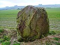
 Sarsen stone near Fiddler's Hill, Hackpen - geograph.org.uk - 553409.jpg 640 × 480; 293 KB
-
 Sarsen stone, Fiddler's Hill - geograph.org.uk - 5783828.jpg 4,000 × 3,000; 4.86 MB
-
-
 Seat and standing stone, Hackpen Hill - geograph.org.uk - 5785605.jpg 4,000 × 3,000; 3.01 MB
-
 Sheep near Uffcott - geograph.org.uk - 5237203.jpg 3,680 × 2,652; 2.89 MB
-
 Sheep on Uffcott Down - geograph.org.uk - 701875.jpg 640 × 480; 167 KB
-

-

-
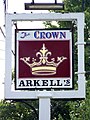 Sign for the Crown Inn - geograph.org.uk - 1437415.jpg 480 × 640; 121 KB
-
 Sign, Broad Hinton - geograph.org.uk - 1437377.jpg 480 × 640; 191 KB
-
 Slurry pit, Manor Farm - geograph.org.uk - 4830965.jpg 4,000 × 3,000; 7.05 MB
-
 Solar farm, Wroughton Airfield - geograph.org.uk - 5237217.jpg 3,030 × 848; 710 KB
-
 Spiky Machine - geograph.org.uk - 1910760.jpg 1,765 × 1,335; 478 KB
-
 Still Some Water to Shift - geograph.org.uk - 3864856.jpg 1,600 × 1,200; 518 KB
-
 Summers Lane - geograph.org.uk - 6571110.jpg 1,200 × 800; 1.14 MB
-
 Summers Lane into Broad Hinton - geograph.org.uk - 6326542.jpg 800 × 600; 132 KB
-
 Summers Lane, Broad Hinton - geograph.org.uk - 3746195.jpg 640 × 480; 118 KB
-
 Sunset near Barbury Castle - geograph.org.uk - 554638.jpg 640 × 480; 210 KB
-
 Telephone box, Broad Hinton - geograph.org.uk - 1437428.jpg 640 × 480; 158 KB
-
 Thatched chalk wall, Uffcott Farm - geograph.org.uk - 4774540.jpg 3,264 × 2,448; 1.95 MB
-
 The A4361 south of Weir Farm - geograph.org.uk - 4830938.jpg 3,264 × 2,448; 3.24 MB
-
 The Barbury Inn. Broad Hinton - geograph.org.uk - 6326532.jpg 800 × 515; 81 KB
-
 The Bell - geograph.org.uk - 104385.jpg 640 × 481; 38 KB
-
 The Bell, on the A4361 - geograph.org.uk - 1566281.jpg 640 × 480; 118 KB
-
 The Church of St Peter ad Vincular at Broad Hinton - geograph.org.uk - 5290406.jpg 4,000 × 3,000; 3.56 MB
-
 The Crown Inn, Broad Hinton - geograph.org.uk - 2289282.jpg 640 × 480; 66 KB
-
 The Crown, Broad Hinton - geograph.org.uk - 104384.jpg 640 × 481; 49 KB
-
 The Crown, Broad Hinton - geograph.org.uk - 1437392.jpg 640 × 480; 87 KB
-
 The lane leading to Broad Hinton - geograph.org.uk - 1566283.jpg 640 × 480; 136 KB
-
 The oldest road - geograph.org.uk - 5405757.jpg 4,320 × 3,240; 3.53 MB
-

-
 The Ridgeway - geograph.org.uk - 4769756.jpg 640 × 480; 65 KB
-
 The Ridgeway - geograph.org.uk - 4769761.jpg 640 × 480; 82 KB
-
 The Ridgeway heading north east - geograph.org.uk - 3519038.jpg 640 × 480; 143 KB
-
 The Ridgeway heading north east - geograph.org.uk - 3519042.jpg 640 × 480; 151 KB
-
 The Ridgeway track near Barbury castle - geograph.org.uk - 31190.jpg 640 × 480; 108 KB
-
 The Ridgeway, Hackpen, Wiltshire - geograph.org.uk - 855467.jpg 640 × 480; 133 KB
-
 The road on Fiddler's Hill - geograph.org.uk - 3797913.jpg 1,536 × 767; 606 KB
-

-

-
 The village well, Broad Hinton - geograph.org.uk - 1566306.jpg 640 × 480; 159 KB
-
 The Well, Broad Hinton - geograph.org.uk - 6271911.jpg 4,320 × 3,240; 4.23 MB
-
 The White Horse Garage. Broad Hinton - geograph.org.uk - 6326535.jpg 800 × 534; 101 KB
-
 The White Horse on Hackpen Hill - geograph.org.uk - 3797920.jpg 1,536 × 1,152; 685 KB
-
 The White Horse Trail near Bincknoll Castle - geograph.org.uk - 4831026.jpg 4,000 × 3,000; 4.79 MB
-
 The White Horse's Head - geograph.org.uk - 3866075.jpg 640 × 473; 115 KB
-
 Track to Bincknoll Castle - geograph.org.uk - 319122.jpg 640 × 480; 60 KB
-
 Track to plantation, near Manor Farm - geograph.org.uk - 4830974.jpg 4,000 × 3,000; 4.79 MB
-
 Twixt two fields - geograph.org.uk - 3102580.jpg 4,320 × 3,240; 4.96 MB
-
 Uffcott House - geograph.org.uk - 3256586.jpg 2,863 × 1,885; 860 KB
-
 Uffcott Phone Box - geograph.org.uk - 1910819.jpg 1,909 × 1,404; 619 KB
-
 Uffcott Pond - geograph.org.uk - 1910785.jpg 2,048 × 1,536; 948 KB
-
 Uffcott Pond - geograph.org.uk - 3256584.jpg 640 × 360; 102 KB
-
 Uffcott Pond - geograph.org.uk - 3912498.jpg 4,000 × 3,000; 3.5 MB
-
 Uffcott Turn - geograph.org.uk - 6571112.jpg 1,200 × 800; 1.04 MB
-
 View along Summers Lane - geograph.org.uk - 1566309.jpg 640 × 480; 156 KB
-
 View along the High Street, Broad Hinton - geograph.org.uk - 1566340.jpg 640 × 480; 179 KB
-
 View along the ridge from Hackpen Hill - geograph.org.uk - 5374821.jpg 4,000 × 3,000; 4.62 MB
-
 View from the Ridgeway - geograph.org.uk - 3519040.jpg 640 × 480; 169 KB
-
 View to the Ridgeway and Hackpen Hill, Uffcott - geograph.org.uk - 6554625.jpg 1,024 × 768; 290 KB
-
 Water tower and barns, Manor Farm - geograph.org.uk - 4830969.jpg 4,000 × 3,000; 4.85 MB
-
 White Cottage, Uffcott - geograph.org.uk - 4774566.jpg 3,264 × 2,448; 1.94 MB
-
 White Cottage, Uffcott - geograph.org.uk - 4774568.jpg 3,264 × 2,448; 1.95 MB
-

-

-

-

-
 Wiltshire oilfields, Hackpen Hill, Uffcott - geograph.org.uk - 1868799.jpg 1,600 × 1,200; 619 KB
-

-
 Bridleway descending from Hackpen Hill - geograph.org.uk - 701847.jpg 640 × 480; 133 KB


_-_geograph.org.uk_-_3102384.jpg)
_-_geograph.org.uk_-_3102386.jpg)
_-_geograph.org.uk_-_3102401.jpg)
_-_geograph.org.uk_-_6272914.jpg)
_-_geograph.org.uk_-_6272920.jpg)
_-_geograph.org.uk_-_6272921.jpg)
_-_geograph.org.uk_-_6272926.jpg)
_(geograph_6271912).jpg)
_(geograph_6272924).jpg)
_-_geograph.org.uk_-_6272925.jpg)
_(geograph_6271913).jpg)
_(geograph_6271914).jpg)
_(geograph_6271915).jpg)
_(geograph_6271932).jpg)
_-_geograph.org.uk_-_6271934.jpg)
_-_geograph.org.uk_-_6271936.jpg)
_-_geograph.org.uk_-_6271939.jpg)
_(geograph_6272913).jpg)
.jpg)
.jpg)


_-_geograph.org.uk_-_3102408.jpg)
_-_geograph.org.uk_-_3102456.jpg)
_-_geograph.org.uk_-_3102469.jpg)


_-_geograph.org.uk_-_6271918.jpg)
_-_geograph.org.uk_-_6271919.jpg)
_-_geograph.org.uk_-_6271921.jpg)
_(geograph_6271923).jpg)
_-_geograph.org.uk_-_6271924.jpg)
_-_geograph.org.uk_-_6271928.jpg)


