Category:Boundary stone BE028
Jump to navigation
Jump to search
| Object location | | View all coordinates using: OpenStreetMap |
|---|
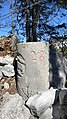
boundary stone of the cantons BE an NE between the municipalities of Saint-Imier / Val-de-Ruz  | |||||
| Upload media | |||||
| Instance of | |||||
|---|---|---|---|---|---|
| Made from material | |||||
| Location | |||||
| Inception |
| ||||
| Width |
| ||||
| Length |
| ||||
| Height |
| ||||
 | |||||
Boundary stone BE028 between canton Neuchâtel and Bern
Media in category "Boundary stone BE028"
The following 11 files are in this category, out of 11 total.
-
 Borne frontière Neuchâtel-Bern BE028 - 01.jpg 4,032 × 2,268; 5.45 MB
-
 Borne frontière Neuchâtel-Bern BE028 - 02.jpg 4,032 × 2,268; 4.47 MB
-
 Borne frontière Neuchâtel-Bern BE028 - 03.jpg 4,032 × 2,268; 4.45 MB
-
 Borne frontière Neuchâtel-Bern BE028 - 04.jpg 2,268 × 4,032; 3.69 MB
-
 Borne frontière Neuchâtel-Bern BE028 - 05.jpg 4,032 × 2,268; 4.19 MB
-
 Borne frontière Neuchâtel-Bern BE028 - 06.jpg 2,268 × 4,032; 4.33 MB
-
 Borne frontière Neuchâtel-Bern BE028 - 07.jpg 4,032 × 2,268; 4.09 MB
-
 Borne frontière Neuchâtel-Bern BE028 - 08.jpg 2,268 × 4,032; 4.03 MB
-
 Borne frontière Neuchâtel-Bern BE028 - 09.jpg 2,268 × 4,032; 3.54 MB
-
 Borne frontière Neuchâtel-Bern BE028 - 10.jpg 4,032 × 2,268; 3.28 MB
-
 Borne frontière Neuchâtel-Bern BE028 - 11.jpg 4,032 × 2,268; 3.46 MB


