Category:Boundary Stones (District of Columbia)
Jump to navigation
Jump to search
Markers that marked the District of Columbia's original boundary | |||||
| Upload media | |||||
| Location |
| ||||
|---|---|---|---|---|---|
| |||||
Subcategories
This category has the following 41 subcategories, out of 41 total.
C
G
N
S
Pages in category "Boundary Stones (District of Columbia)"
This category contains only the following page.
Media in category "Boundary Stones (District of Columbia)"
The following 5 files are in this category, out of 5 total.
-
 1908 40 stones DCSO autoadjust r c.pdf 1,943 × 1,333; 2.11 MB
-
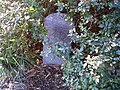 DC Boundary Marker at SS traffic circle.jpg 1,600 × 1,200; 705 KB
-
 District of Columbia boundary stone LCCN2016891629.jpg 10,008 × 7,752; 12.81 MB
-
 District of Columbia boundary stone LCCN2016891629.tif 10,008 × 7,752; 147.98 MB
-
 Map of Alexandria County, Virginia showing DC Boundary Stones.png 1,406 × 1,242; 603 KB


