Category:Black Bourton
Jump to navigation
Jump to search
village and civil parish in West Oxfordshire, England | |||||
| Upload media | |||||
| Instance of |
| ||||
|---|---|---|---|---|---|
| Location | West Oxfordshire, Oxfordshire, South East England, England | ||||
| Population |
| ||||
| official website | |||||
 | |||||
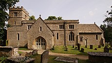
English: Black Bourton is a village and civil parish about south of Carterton. The village is on Black Bourton Brook, a tributary of the River Thames.
Subcategories
This category has the following 2 subcategories, out of 2 total.
B
M
Media in category "Black Bourton"
The following 38 files are in this category, out of 38 total.
-
Airbus A400M Atlas at RAF Brize Norton - geograph.org.uk - 6572764.jpg 4,608 × 3,456; 4.44 MB
-
Airliner over Brize Norton - geograph.org.uk - 294613.jpg 640 × 427; 58 KB
-
B4020 enters Alvescot - geograph.org.uk - 3044403.jpg 3,531 × 2,454; 1.14 MB
-
Bampton Road junction with Station Road - geograph.org.uk - 3044398.jpg 3,648 × 2,736; 1.58 MB
-
Bampton Road, Black Bourton - geograph.org.uk - 4398079.jpg 800 × 450; 192 KB
-
Black Bourton, The Old Inn.jpg 640 × 480; 82 KB
-
Black Bourton playing field - geograph.org.uk - 1084900.jpg 640 × 480; 63 KB
-
Black Bourton pub.jpg 640 × 480; 86 KB
-
Black Bourton, former methodist chapel.jpg 640 × 427; 104 KB
-
Black Bourton, St Mary the Virgin - geograph.org.uk - 5476440.jpg 4,608 × 3,456; 5.23 MB
-
BlackBourton SchoolHouse.jpg 1,280 × 720; 501 KB
-
Bridge on the B4020 - geograph.org.uk - 1864765.jpg 640 × 480; 79 KB
-
Brize Norton Airfield from the air - geograph.org.uk - 5612623.jpg 3,264 × 2,448; 4.65 MB
-
Brook at Black Bourton - geograph.org.uk - 1116101.jpg 640 × 427; 83 KB
-
Burford Road junction with Bampton Lane - geograph.org.uk - 3044396.jpg 2,945 × 2,336; 1.37 MB
-
Calcroft Lane - geograph.org.uk - 4397094.jpg 800 × 450; 203 KB
-
Castle Vineyard, Black Bourton - geograph.org.uk - 1116118.jpg 640 × 427; 57 KB
-
Derelict building in Sewage Works near Alvescot - geograph.org.uk - 6572769.jpg 4,316 × 3,204; 3.94 MB
-
Farm track - geograph.org.uk - 324595.jpg 640 × 480; 102 KB
-
Former mushroom farm - geograph.org.uk - 1084897.jpg 640 × 480; 85 KB
-
Houses, Black Bourton - geograph.org.uk - 6572044.jpg 4,608 × 3,456; 7.59 MB
-
Junction in Black Bourton - geograph.org.uk - 1116082.jpg 640 × 427; 44 KB
-
Leaving Black Bourton - geograph.org.uk - 1116096.jpg 640 × 427; 71 KB
-
Memorial by the road to Black Bourton - geograph.org.uk - 6572023.jpg 4,608 × 3,456; 7.63 MB
-
Military graves in Black Bourton churchyard - geograph.org.uk - 6571604.jpg 4,000 × 3,000; 4.48 MB
-
Minor Road, Black Bourton - geograph.org.uk - 5592582.jpg 3,264 × 2,448; 1.73 MB
-
Optare Solo AE56 LUO BlackBourton.jpg 1,280 × 720; 549 KB
-
Oxfordshire fieldscape with airfield - geograph.org.uk - 4937269.jpg 3,264 × 2,448; 3.77 MB
-
Public footpaths near RAF Brize Norton - geograph.org.uk - 6571593.jpg 4,608 × 3,456; 6.2 MB
-
RAF Brize Norton - geograph.org.uk - 6571550.jpg 4,608 × 3,456; 6.98 MB
-
St Mary the Virgin's Church, Black Bourton - geograph.org.uk - 5592552.jpg 4,608 × 3,456; 4.04 MB
-
The Vines - geograph.org.uk - 3044390.jpg 3,648 × 2,736; 2.07 MB
-
Yarnold Sangar pillbox, RAF Brize Norton - geograph.org.uk - 6572392.jpg 4,608 × 3,456; 5.46 MB
-
Barn at Home Farm - geograph.org.uk - 294615.jpg 640 × 427; 113 KB
-
Lane to Mill Farm - geograph.org.uk - 294609.jpg 640 × 427; 93 KB


