Category:Battyeford
Jump to navigation
Jump to search
village in United Kingdom  | |||||
| Upload media | |||||
| Instance of | |||||
|---|---|---|---|---|---|
| Location | Mirfield, Kirklees, West Yorkshire, Yorkshire and the Humber, England | ||||
 | |||||
English: Battyeford is a village in West Yorkshire, England now no more than an area of the larger town of Mirfield.
Subcategories
This category has the following 2 subcategories, out of 2 total.
F
Media in category "Battyeford"
The following 42 files are in this category, out of 42 total.
-
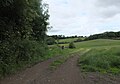
 Across farmland towards Battyeford - geograph.org.uk - 81628.jpg 640 × 480; 122 KB
-

-

-
 Battyeford - railway footbridge - geograph.org.uk - 1579582.jpg 640 × 480; 146 KB
-
 Battyeford Hauling Bridge (26729793034).jpg 2,373 × 2,373; 5.02 MB
-
 Battyeford Hauling Bridge - geograph.org.uk - 3896905.jpg 1,600 × 1,200; 386 KB
-

-

-
 Battyeford Playing fields - geograph.org.uk - 169540.jpg 640 × 480; 87 KB
-
 Battyeford Station site of 1772802 e54962dd.jpg 640 × 382; 118 KB
-
 Battyeford-viaduct-by-Nigel-Homer.jpg 640 × 480; 97 KB
-
 Bracken Close - Stocks Bank Road - geograph.org.uk - 1438493.jpg 640 × 480; 268 KB
-
 Bracken Grove - Stocks Bank Road - geograph.org.uk - 1438506.jpg 640 × 480; 238 KB
-
-
 Bridleway heading towards Hartshead from Leeds Road - geograph.org.uk - 6203376.jpg 2,000 × 1,398; 2.19 MB
-
 Building site off Leeds Road (A62) - geograph.org.uk - 6442867.jpg 2,000 × 953; 2.47 MB
-
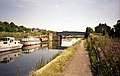
 Calder and Hebble Navigation, Battyeford - geograph.org.uk - 82548.jpg 640 × 480; 116 KB
-
 Canal work boat - geograph.org.uk - 749676.jpg 640 × 514; 131 KB
-
 Christ the King Church, Battyeford - geograph.org.uk - 938779.jpg 640 × 454; 131 KB
-

-
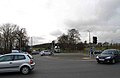 Cooper Bridge roundabout - geograph.org.uk - 737992.jpg 640 × 414; 48 KB
-
 Cooper-Bridge-entrance-by-Humphrey-Bolton.jpg 640 × 473; 87 KB
-
 Coppin Hall Lane - Stocks Bank Road - geograph.org.uk - 1438497.jpg 640 × 480; 245 KB
-

-
 Fantastic gateposts at Cooper Bridge - geograph.org.uk - 738003.jpg 640 × 480; 106 KB
-
 Footpath - Stocks Bank Road - geograph.org.uk - 1438504.jpg 480 × 640; 318 KB
-

-
 Milepost, Leeds Road, Mirfield (geograph 6409736).jpg 1,361 × 2,000; 1.35 MB
-
 Milepost, Leeds Road, Mirfield (geograph 6409738).jpg 2,000 × 1,086; 856 KB
-

-
 Pear Tree, Battyeford (8731685521).jpg 2,230 × 1,784; 2.16 MB
-
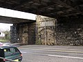
 Railway bridges across the River Calder near Bracken Hill - geograph.org.uk - 5285989.jpg 4,223 × 2,626; 2.05 MB
-
 Reflections in the Battye Cut (3402693934).jpg 2,560 × 1,920; 4.08 MB
-
 River Calder, Battyeford - geograph.org.uk - 169511.jpg 640 × 480; 82 KB
-
 River Calder, Battyeford, Mirfield - geograph.org.uk - 55468.jpg 640 × 480; 85 KB
-

-
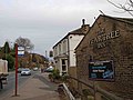 The Pear Tree Inn Battyeford - geograph.org.uk - 737857.jpg 640 × 480; 72 KB
-
 The pink narrowboat - geograph.org.uk - 749674.jpg 640 × 373; 80 KB
-

-

-

-


.jpg)


_-_geograph.org.uk_-_6442867.jpg)


.jpg)
.jpg)

.jpg)

.jpg)


