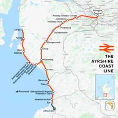
Category:Ayrshire Coast Line
Jump to navigation
Jump to search
line within the Strathclyde suburban rail network in Scotland | |||||
| Upload media | |||||
| Instance of | |||||
|---|---|---|---|---|---|
| Part of |
| ||||
| Location | Scotland | ||||
| Owned by | |||||
| Operator | |||||
| Has part(s) |
| ||||
| |||||
Subcategories
This category has the following 35 subcategories, out of 35 total.
A
- Arkleston junction (4 F)
- Ayr railway viaduct (11 F)
B
- Barassie railway station (21 F)
D
- Dalry railway station (10 F)
E
F
- Fairlie railway station (25 F)
G
- Gailes railway station (3 F)
I
- Irvine railway station (9 F)
J
- Johnstone railway station (19 F)
K
- Kilwinning railway station (39 F)
L
M
N
P
Q
- Queen's Bridge, Irvine (3 F)
S
- Saltcoats railway station (12 F)
T
- Troon railway station (46 F)
W
Media in category "Ayrshire Coast Line"
The following 28 files are in this category, out of 28 total.
-
Ayrshire Coast Line.png 1,727 × 1,738; 1.86 MB
-
Ailsa Craig View - geograph.org.uk - 2857630.jpg 411 × 640; 105 KB
-
Ardrossan - geograph.org.uk - 660198.jpg 640 × 480; 66 KB
-
Ayr - Kilmarnock railway - geograph.org.uk - 1672177.jpg 640 × 480; 144 KB
-
Ayrshire Coast Line, Troon, South Ayrshire - geograph.org.uk - 6375187.jpg 1,600 × 1,038; 590 KB
-
Curling Stone Quarries and North Foghorn, Ailsa Craig.JPG 4,414 × 2,628; 4.42 MB
-
Dalry bypass flyover (geograph 6994367).jpg 1,024 × 717; 200 KB
-
DSM Dalry railway connection.JPG 2,288 × 1,712; 1.27 MB
-
East Trammins and the South Foghorn, Ailsa Craig.JPG 3,074 × 2,304; 2.82 MB
-
East Trammins, Foghorn and course of old railway, Ailsa Craig.JPG 2,262 × 1,869; 1.55 MB
-
Eglington Road Roundabout (geograph 3994686).jpg 3,456 × 2,304; 3.55 MB
-
Irvine estuary - geograph.org.uk - 1444991.jpg 640 × 410; 54 KB
-
Little Ailsa Islet and Basalt Columns.JPG 3,074 × 2,304; 2.94 MB
-
Little Ailsa Islet, Ailsa Craig.JPG 2,306 × 3,074; 2.74 MB
-
MacNall's Cave and Little Ailsa, Ailsa Craig.JPG 3,696 × 2,569; 3.52 MB
-
Mineral Railway embankment, Kennedy's Nags, Ailsa Craig.JPG 2,642 × 1,488; 2 MB
-
New Railway Bridge - geograph.org.uk - 165420.jpg 640 × 479; 100 KB
-
North Foghorn and Swine Cave, Ailsa Craig.JPG 3,655 × 2,370; 3.66 MB
-
Rail map Scotland Ayrshire Coast line.png 1,349 × 1,683; 379 KB
-
Roadstone Quarry and mineral railway remnants, Ailsa Craig.JPG 2,534 × 1,535; 1.72 MB
-
Roadstone Quarry at Kennedy's Nag, Ailsa Craig.JPG 3,074 × 2,304; 3.38 MB
-
Stevenston rail flyover.jpg 1,536 × 1,152; 423 KB
-
Stone Crusher remnants at the South Foghorn, the Trammins, Ailsa Craig.JPG 2,051 × 1,563; 1.7 MB
-
The Bourtrees, South Foghorn, mineral railway embankmenr, etc. Ailsa Craig.JPG 4,592 × 3,434; 6.21 MB
-
The Loups path and Swine Holes, Ailsa Craig.JPG 4,187 × 2,563; 7.39 MB
-
The Loups Path on Ailsa Craig.JPG 4,608 × 3,456; 3.64 MB
-
Track over railway. - geograph.org.uk - 612652.jpg 640 × 480; 58 KB


