Category:Atlas of Norfolk County, Massachusetts (1876)
Jump to navigation
Jump to search
Media in category "Atlas of Norfolk County, Massachusetts (1876)"
The following 5 files are in this category, out of 5 total.
-
 1876 map of Allenville, East Walpole, and South Walpole.png 2,524 × 3,170; 14.95 MB
-
 1876 map of Readville.png 3,000 × 1,915; 8.69 MB
-
 1876 Walpole map.png 1,914 × 3,000; 6.15 MB
-
 1876 Walpole town map.png 2,507 × 3,191; 14.68 MB
-
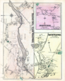
 Junction detail on 1876 Walpole map.png 526 × 403; 466 KB


