Category:Atlas Schoemaker
Dutch atlas created around 1720   | |||||
| Upload media | |||||
| Instance of | |||||
|---|---|---|---|---|---|
| Location | KB National Library of the Netherlands, The Hague, South Holland, Netherlands | ||||
| Creator | |||||
| Collection | |||||
| Start time |
| ||||
| Inception |
| ||||
| End time |
| ||||
| |||||
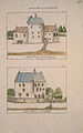
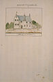
The Atlas Schoemaker displays 2579 images of topographical drawings, descriptions and prints of Dutch towns, villages and hamlets in the early 18th century.
Andries Schoemaker (1660–1735) was an Amsterdam textile merchant whose passion was collecting historical and topographic information on towns and villages, and churches and castles in the Netherlands. In the 1720s, he visited almost all the towns, villages and hamlets in the Netherlands, often accompanied by his son Gerrit Schoemaker (1692–1736). He described the places he visited during these trips, including historical and cultural details.
Schoemaker often illustrated his descriptions by means of drawings, many in color, that he either made himself or had made by contemporary artists, such as Cornelis Pronk (1691–1759) and his apprentice Abraham de Haen II (1707–1748). At times he also made use of prints previously published to show the topographic situation in earlier periods. He either redrew these prints or he pasted them in his books. Occasionally he also made his own sketch maps or used existing maps in his work.
In July 2015 the National Library of the Netherlands has added the 2579 images to this category using the GLAMwiki uploadtool. The images and metadata were taken from http://www.geheugenvannederland.nl/?/en/collecties/schoemaker.
Subcategories
This category has the following 11 subcategories, out of 11 total.
C
- Atlas Schoemaker-Castles (160 F)
D
- Atlas Schoemaker-Drenthe (7 F)
F
G
- Atlas Schoemaker-Groningen (47 F)
- Atlas Schoemaker-Gelderland (14 F)
N
- Atlas Schoemaker-Noord-Brabant (100 F)
O
- Atlas Schoemaker-Overijssel (103 F)
U
Z
- Atlas Schoemaker-Zeeland (166 F)
- Atlas Schoemaker-Zuid-Holland (845 F)
Media in category "Atlas Schoemaker"
The following 46 files are in this category, out of 46 total.
-
 Atlas Schoemaker-GRONINGEN-2740-Groningen, Groningen en Ommelanden.jpeg 1,068 × 1,672; 396 KB
-
 Atlas Schoemaker-GRONINGEN-2741-Groningen, Groningen en ommelanden.jpeg 1,068 × 1,672; 383 KB
-
 Atlas Schoemaker-GRONINGEN-2743-Groningen, Zandeweer.jpeg 1,053 × 1,680; 251 KB
-
 Atlas Schoemaker-GRONINGEN-2744-Groningen, Appingedam.jpeg 1,061 × 1,672; 214 KB
-
 Atlas Schoemaker-GRONINGEN-2745-Groningen, Appingedam.jpeg 1,053 × 1,664; 336 KB
-
 Atlas Schoemaker-GRONINGEN-2746-Groningen, Ulrum.jpeg 1,038 × 1,672; 197 KB
-
 Atlas Schoemaker-GRONINGEN-2747-Groningen, Bourtange.jpeg 1,053 × 1,680; 308 KB
-
 Atlas Schoemaker-GRONINGEN-2748-Groningen, Bourtange.jpeg 1,053 × 1,680; 336 KB
-
 Atlas Schoemaker-GRONINGEN-2750-Groningen, Breede.jpeg 1,046 × 1,680; 227 KB
-
 Atlas Schoemaker-GRONINGEN-2751-Groningen, Oudeschans.jpeg 1,053 × 1,664; 224 KB
-
 Atlas Schoemaker-GRONINGEN-2753-Groningen, Winsum.jpeg 1,068 × 1,680; 246 KB
-
 Atlas Schoemaker-GRONINGEN-2754-Groningen, Delfzijl.jpeg 1,068 × 1,680; 349 KB
-
 Atlas Schoemaker-GRONINGEN-2756-Groningen, Feerwerd.jpeg 1,046 × 1,680; 231 KB
-
 Atlas Schoemaker-GRONINGEN-2757-Groningen, Groningen.jpeg 1,068 × 1,672; 331 KB
-
 Atlas Schoemaker-GRONINGEN-2758-Groningen, Groningen.jpeg 1,068 × 1,672; 327 KB
-
 Atlas Schoemaker-GRONINGEN-2760-Groningen, Groningen.jpeg 1,061 × 1,680; 255 KB
-
 Atlas Schoemaker-GRONINGEN-2761-Groningen, Groningen.jpeg 1,061 × 1,656; 196 KB
-
 Atlas Schoemaker-GRONINGEN-2762-Groningen, Groningen.jpeg 1,046 × 1,664; 193 KB
-
 Atlas Schoemaker-GRONINGEN-2764-Groningen, Bedum.jpeg 1,068 × 1,672; 243 KB
-
 Atlas Schoemaker-GRONINGEN-2765-Groningen, Garmerwolde.jpeg 1,053 × 1,680; 260 KB
-
 Atlas Schoemaker-GRONINGEN-2767-Groningen, Doesum.jpeg 1,053 × 1,680; 234 KB
-
 Atlas Schoemaker-GRONINGEN-2769-Groningen, Holwinde.jpeg 1,061 × 1,656; 243 KB
-
 Atlas Schoemaker-GRONINGEN-2770-Groningen, Huizinge.jpeg 1,053 × 1,680; 203 KB
-
 Atlas Schoemaker-GRONINGEN-2771-Groningen, Jemmingen.jpeg 1,053 × 1,680; 329 KB
-
 Atlas Schoemaker-GRONINGEN-2772-Groningen, Loppersum.jpeg 1,053 × 1,680; 326 KB
-
 Atlas Schoemaker-GRONINGEN-2774-Groningen, Zuidhorn.jpeg 1,053 × 1,680; 229 KB
-
 Atlas Schoemaker-GRONINGEN-2775-Groningen, Leens.jpeg 1,053 × 1,680; 204 KB
-
 Atlas Schoemaker-GRONINGEN-2776-Groningen, Nieuweschans.jpeg 1,053 × 1,680; 255 KB
-
 Atlas Schoemaker-GRONINGEN-2778-Groningen, Huizinge.jpeg 1,053 × 1,680; 240 KB
-
 Atlas Schoemaker-GRONINGEN-2780-Groningen, Bierum.jpeg 1,053 × 1,680; 229 KB
-
 Atlas Schoemaker-GRONINGEN-2782-Groningen, Middelstum.jpeg 1,053 × 1,680; 244 KB
-
 Atlas Schoemaker-GRONINGEN-2783-Groningen, Noorddijk.jpeg 1,053 × 1,680; 216 KB
-
 Atlas Schoemaker-GRONINGEN-2784-Groningen, Nienoord.jpeg 1,053 × 1,680; 195 KB
-
 Atlas Schoemaker-GRONINGEN-2786-Groningen, Wiitewierum.jpeg 1,053 × 1,680; 262 KB
-
 Atlas Schoemaker-GRONINGEN-2787-Groningen, Ripperda.jpeg 1,053 × 1,680; 343 KB
-
 Atlas Schoemaker-GRONINGEN-2788-Groningen, Pieterburen.jpeg 1,053 × 1,680; 201 KB
-
 Atlas Schoemaker-GRONINGEN-2789-Groningen, Rasguert.jpeg 1,053 × 1,688; 210 KB
-
 Atlas Schoemaker-GRONINGEN-2791-Groningen, Stedum.jpeg 1,053 × 1,688; 255 KB
-
 Atlas Schoemaker-GRONINGEN-2793-Groningen, Groot Wetsinge.jpeg 1,068 × 1,680; 249 KB
-
 Atlas Schoemaker-GRONINGEN-2795-Groningen, Sauwerd.jpeg 1,068 × 1,680; 259 KB
-
 Atlas Schoemaker-GRONINGEN-2797-Groningen, Zuidhorn.jpeg 1,068 × 1,680; 252 KB
-
 Atlas Schoemaker-GRONINGEN-2799-Groningen, Warffum.jpeg 1,053 × 1,688; 252 KB
-
 Atlas Schoemaker-GRONINGEN-2801-Groningen, Warfhuizen.jpeg 1,068 × 1,664; 246 KB
-
 Atlas Schoemaker-GRONINGEN-2802-Groningen, Wedde.jpeg 1,091 × 1,680; 271 KB
-
 Atlas Schoemaker-GRONINGEN-2804-Groningen, Warfhuizen.jpeg 1,091 × 1,680; 215 KB
-
 Tekening, overzicht - Nieuwer-Amstel - 20164504 - RCE.jpg 3,824 × 2,849; 2.15 MB


